DENVER-1
(Last updated 1/28/04)
William Larimer founded Denver City in November,
1858 - five months after gold was discovered at the confluence
of Cherry Creek and the South Platte by William Russell in what
was then the Kansas Territory. Larimer named his town after territorial
governor James W. Denver in order to curry political favor over
regional rivals, in particular Golden City. Over the next
two years, nearby gold strikes sparked the migration of over 100,000
people into the region, leading to the establishment of the independent
Colorado Territory. Nevertheless, although it quickly engulfed
its early local rivals Auraria (founded on the opposite bank of
the Creek by Russell) and Mexican Diggings (supposedly the site
of an earlier strike a few miles up the Platte by mountain man
John Smith), Denver remained a stagnant town of less than 5,000
until 1870, when the first railroad - the Denver Pacific, a locally
financed 106-mile spur off the transcontinental railroad from
Cheyenne - came to town. Sparked by this arrival - and further
discoveries of gold and silver, Denver gradually evolved into
an agricultural, manufacturing, and warehouse center; and by 1890,
it had grown by over 100,000 inhabitants, becoming the second
most populous city in the West (after San Francisco).
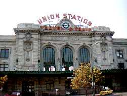
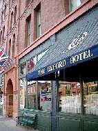
Digital pix from a walking tour
down Denver's main axis on a very hot afternoon: Union Station (left), located less than 1/4 mile east
of the confluence strike, was built in 1881, the same year that
Denver was officially voted the capital of the new state (1876)
of Colorado; by 1900, the Station accomodated dozens of railroads,
and passengers arriving on over 100 trains a day. A block
south of Union Station, the red brick Oxford Hotel (right), built
in 1891, is Denver's oldest; the hotel was restored and had a
grand reopening in 1983
 The 25-square block area of Denver's
Lower Downtown, or LoDo, is part of the city's original townsite
and still contains a significant collection of late 19th and early
20th century industrial structures, thanks in part to a scarcity
of local timber and the area's underlying layer of good clay;
the buildings are relatively homogeneous, with rectangular shapes,
red brick facades, and many windows. Beginning in the mid-80s,
the City and County governments of Denver passed a series of zoning
changes and code restrictions that culminated in LoDo's certification
as an Historic District by the National Park Service in 1988.
Historic buildings have been renovated to accomodate offices,
housing, and retail space, and supplemented by significant new
construction (which must conform to a strict design code). Today
LoDo is an upscale neighborhood of art galleries, jazz clubs,
restaurants, brewpubs, and specialty stores.
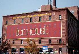
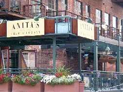
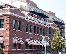
A block east of Union Station, the
IceHouse (left) contains loft housing and Anita's Crab Company
Restaurant (right) in what was once the Littleton Creamery Building
(1903)
The 25-square block area of Denver's
Lower Downtown, or LoDo, is part of the city's original townsite
and still contains a significant collection of late 19th and early
20th century industrial structures, thanks in part to a scarcity
of local timber and the area's underlying layer of good clay;
the buildings are relatively homogeneous, with rectangular shapes,
red brick facades, and many windows. Beginning in the mid-80s,
the City and County governments of Denver passed a series of zoning
changes and code restrictions that culminated in LoDo's certification
as an Historic District by the National Park Service in 1988.
Historic buildings have been renovated to accomodate offices,
housing, and retail space, and supplemented by significant new
construction (which must conform to a strict design code). Today
LoDo is an upscale neighborhood of art galleries, jazz clubs,
restaurants, brewpubs, and specialty stores.
A block east of Union Station, the
IceHouse (left) contains loft housing and Anita's Crab Company
Restaurant (right) in what was once the Littleton Creamery Building
(1903)
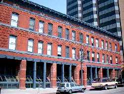
 Further east at 19th and Wynkoop, the
Denver Chop House & Brewery (left) occupies an old Union Pacific
warehouse; the shops next door are trendy, and expensive (right)
Further east at 19th and Wynkoop, the
Denver Chop House & Brewery (left) occupies an old Union Pacific
warehouse; the shops next door are trendy, and expensive (right)
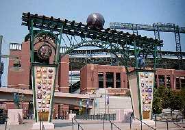
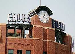
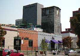
 Coors Field (1992-95), home of the
Colorado Rockies, defines LoDo's northeast (20th Street) boundary
- the Field's construction helped to fuel urban renewal in the
District, as well as in what is now called the "Ballpark
neighborhood" to its north; a massive multi-level structure,
the Field contains nearly a million and a half red bricks
Coors Field (1992-95), home of the
Colorado Rockies, defines LoDo's northeast (20th Street) boundary
- the Field's construction helped to fuel urban renewal in the
District, as well as in what is now called the "Ballpark
neighborhood" to its north; a massive multi-level structure,
the Field contains nearly a million and a half red bricks
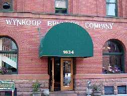
 Back on 18th, the Wynkoop Brewing Company
(left) is housed in the J.S. Brown Mercantile Building (1899)
- one of the largest brew pubs in the world, it's a strong indicator
that microbrews are serious business in Denver; the F.W. Crocker
Building (1887; right), built as a steam cracker factory, was
used as a bakery by Nabisco until 1945
Back on 18th, the Wynkoop Brewing Company
(left) is housed in the J.S. Brown Mercantile Building (1899)
- one of the largest brew pubs in the world, it's a strong indicator
that microbrews are serious business in Denver; the F.W. Crocker
Building (1887; right), built as a steam cracker factory, was
used as a bakery by Nabisco until 1945
 A row of mercantile buildings, probably
from the 1870s, is now home to a series of trendy offices (left);
back on 16th and a few blocks south of Union Station, the Market
Street Bus Terminal and the Denver Post building (at lower left)
mark the start of the 16th Street Mall (right)
A row of mercantile buildings, probably
from the 1870s, is now home to a series of trendy offices (left);
back on 16th and a few blocks south of Union Station, the Market
Street Bus Terminal and the Denver Post building (at lower left)
mark the start of the 16th Street Mall (right)
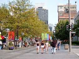
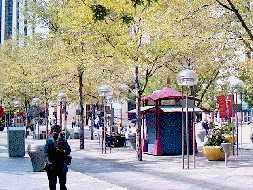
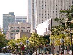
 The Mall is closed to traffic, providing
a 13-block long pedestrian-friendly stretch of trees, benches,
and street life that extends the length of the Central Business
District (from NW to SE - the CBD, together with LoDo, is actually
oriented at 45 degrees to the rest of the city), although free
shuttle buses - powered by hybrid electric systems - are available
to carry shoppers and other visitors back and forth along its
length.
The Mall is closed to traffic, providing
a 13-block long pedestrian-friendly stretch of trees, benches,
and street life that extends the length of the Central Business
District (from NW to SE - the CBD, together with LoDo, is actually
oriented at 45 degrees to the rest of the city), although free
shuttle buses - powered by hybrid electric systems - are available
to carry shoppers and other visitors back and forth along its
length.
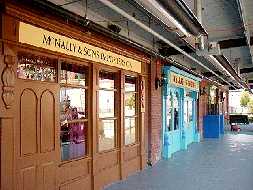
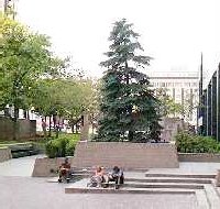
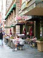
 The lower end of the Mall is lined
with squares, like Writer's (center) - which houses 30 shops and
restaurants, and even a market.
The lower end of the Mall is lined
with squares, like Writer's (center) - which houses 30 shops and
restaurants, and even a market.
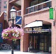
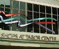
 Almost all of the CBD's historic architecture
was razed to accomodate Denver's oil-funded building boom of the
'70s and '80s; the Tabor Center Complex (1984), which occupies
the land that once held Denver's first "skyscraper,"
includes a 30-story office tower, the shorter tower of the Westin
Hotel, a two-block long Galleria with pedestrian mall, and one
landmark that remains - the renovated D&F Tower (1910; right),
originally home to the Daniels & Fisher Department Store,
and Denver's tallest building for almost 50 years
Almost all of the CBD's historic architecture
was razed to accomodate Denver's oil-funded building boom of the
'70s and '80s; the Tabor Center Complex (1984), which occupies
the land that once held Denver's first "skyscraper,"
includes a 30-story office tower, the shorter tower of the Westin
Hotel, a two-block long Galleria with pedestrian mall, and one
landmark that remains - the renovated D&F Tower (1910; right),
originally home to the Daniels & Fisher Department Store,
and Denver's tallest building for almost 50 years
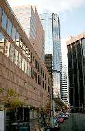
 The center stretch of the Mall is lined
with hotels, high rise apartments and condominiums (particularly
between Champa and California Streets), office buildings like
the MCI Tower, and shopping, entertainment, and dining destinations
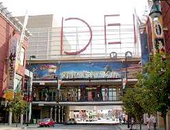
like The Pavillions (right), with over 40 stores and restaurants,
including the Wolfgang Puck Cafe
The center stretch of the Mall is lined
with hotels, high rise apartments and condominiums (particularly
between Champa and California Streets), office buildings like
the MCI Tower, and shopping, entertainment, and dining destinations
like The Pavillions (right), with over 40 stores and restaurants,
including the Wolfgang Puck Cafe
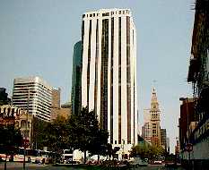
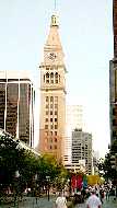
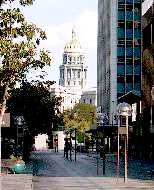
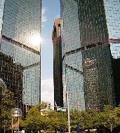
 The upper end of the Mall, which frames
the State Capitol Building (left), also has its share of sidewalk
cafes (center), but is anchored by high rise buildings like the
asymmetric twin towers of the World Trade Center (right) and the
massive 1225-room Adams Mark Hotel
The upper end of the Mall, which frames
the State Capitol Building (left), also has its share of sidewalk
cafes (center), but is anchored by high rise buildings like the
asymmetric twin towers of the World Trade Center (right) and the
massive 1225-room Adams Mark Hotel
 Go to Denver-2 | Return
to Home Page
Go to Denver-2 | Return
to Home Page