HAWAI'I-2
(Last updated 2/13/04)
The Hawaiian chain began about 70 million
years ago with a small rupture in the earth's mantle that allowed
magma to well up from its core through the Pacific tectonic plate;
as the plate moved north, the escaping magma formed the Emperor
Seamounts, which run south from the coast of Russia. Then, possibly
because of the collision of India into the Asian continent, ca
43 million years ago the plate's motion took a 45 degree bend
to the west and slowed, so that mounds of rock piled up, producing
island after island. The oldest to have survived is Kure, once
massive, now only a ghost in the form of a fringed coral reef.
The newest in the chain, a now roughly triangular-shaped speck
in the ocean born less than a million years ago, is the island
of Hawai'i, usually called the Big Island both because of its
size - at 4000 sq mi, it's bigger than all of the other islands
combined - and to avoid confusion with the name of the state.
(But an undersea volcano called Lo'ihi, about 20 miles to the
southeast of the BI, is only ca 3000 ft below the surface and
should emerge within the next 100,000 years!)
At least four of the five volcanoes
on the BI are still active: 13,796 ft Mauna Kea (topping 32,000
ft when measured from its base on the sea floor, it's the tallest
mountain in the world) - in the northeast (and in its prime half
a million years ago), it last erupted ca 4000 years ago; 8271-ft
Hualalai - in the center of the west coast, it last erupted in
1801; 13,677 ft Mauna Loa (the largest mountain in the world,
making up half the mass of the BI) - at the center of the island,
it last erupted in 1984...
 ...and Kilauea - on the slope of ML
in the southeast, it has been erupting continuously since January,
1983! Sending out up to a million cubic yards of lava a day from
the Pu'u 'O'o vent on its eastern rift zone, Kilauea has covered
over 40 sq mi - including a town (Kalapana) and roads, as well
as forming over 600 acres of new land as its lava flows into the
Pacific. The Kilauea Caldera, ca 4 mi wide by 3 mi high, is located
at the northern end of Hawai'i Volcanoes National Park
...and Kilauea - on the slope of ML
in the southeast, it has been erupting continuously since January,
1983! Sending out up to a million cubic yards of lava a day from
the Pu'u 'O'o vent on its eastern rift zone, Kilauea has covered
over 40 sq mi - including a town (Kalapana) and roads, as well
as forming over 600 acres of new land as its lava flows into the
Pacific. The Kilauea Caldera, ca 4 mi wide by 3 mi high, is located
at the northern end of Hawai'i Volcanoes National Park
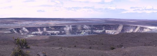
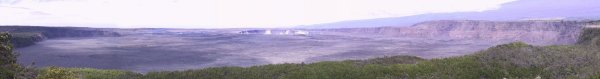 A drive on the road around Kilauea's
rim (at an altitude of ca 4000 ft) provides a great panoramic
view of the steaming Halema'uma'u Crater in its southwest corner.
Now crusted over, this crater-in-a-crater was a boiling lava lake
for most of the 18th and 19th centuries, and exploded eruptively
in 1924; it is still revered as the home of the goddess Pele by
many native Hawaiians, who leave offerings near its rim
A drive on the road around Kilauea's
rim (at an altitude of ca 4000 ft) provides a great panoramic
view of the steaming Halema'uma'u Crater in its southwest corner.
Now crusted over, this crater-in-a-crater was a boiling lava lake
for most of the 18th and 19th centuries, and exploded eruptively
in 1924; it is still revered as the home of the goddess Pele by
many native Hawaiians, who leave offerings near its rim
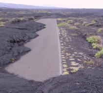
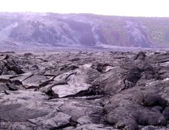
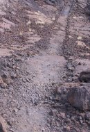
 The 20-mi long Chain of Craters Road
(rerouted after 12 miles of its middle section were covered during
the 1969-74 lava flow from the Mauna Ulu vent) runs south from
the KC rim road past a number of crater overlooks and lava flows,
eventually leading down to the coast - where it dead ends abruptly
at a mobile 'Park Visitors Center'. Beyond lies a lava wasteland,
with no trails or markers once you get past the initial sections
of partially covered highway (left); after walking parallel to
the coast for several miles, steam plumes can be seen in the distance
(right), marking where Kilauea's lava flows into the ocean. [Unfortunately
the plumes react with sunlight and the 2000 tons of sulfur dioxide
that the eruption also spews out daily, forming a corrosive, lung-choking
aerosol cloud the locals call "vog" - which is then
spread around the BI by the tradewinds.]
The 20-mi long Chain of Craters Road
(rerouted after 12 miles of its middle section were covered during
the 1969-74 lava flow from the Mauna Ulu vent) runs south from
the KC rim road past a number of crater overlooks and lava flows,
eventually leading down to the coast - where it dead ends abruptly
at a mobile 'Park Visitors Center'. Beyond lies a lava wasteland,
with no trails or markers once you get past the initial sections
of partially covered highway (left); after walking parallel to
the coast for several miles, steam plumes can be seen in the distance
(right), marking where Kilauea's lava flows into the ocean. [Unfortunately
the plumes react with sunlight and the 2000 tons of sulfur dioxide
that the eruption also spews out daily, forming a corrosive, lung-choking
aerosol cloud the locals call "vog" - which is then
spread around the BI by the tradewinds.]
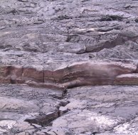
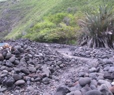
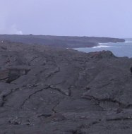 After a few more miles, steam plumes
on the cliffs to the left mark the passage of the descending lava
(left); once down on the coastal shelf, the lava continues its
path to the sea through tubes just under the newly created surface
- here a crack in the lava crust (right) glows red and steams,
marking the passage of the molten rock a foot or so beneath (it's
not a good idea to stand here for long - surface cave-ins and
mini-explosions of trapped methane gas are not uncommon, and heat
from the surface can penetrate the thickest boot soles)
After a few more miles, steam plumes
on the cliffs to the left mark the passage of the descending lava
(left); once down on the coastal shelf, the lava continues its
path to the sea through tubes just under the newly created surface
- here a crack in the lava crust (right) glows red and steams,
marking the passage of the molten rock a foot or so beneath (it's
not a good idea to stand here for long - surface cave-ins and
mini-explosions of trapped methane gas are not uncommon, and heat
from the surface can penetrate the thickest boot soles)
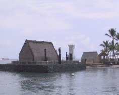
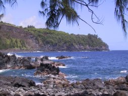
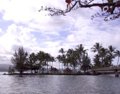
 The west, or Kona, coast of the BI
is the leeward side of the island; it gets very little rain and
lots of sunshine. The town of Kailua-Kona
sits in the middle of the coast, and also in the lee of Hualalai
where it's protected from the tradewinds as well as from the rain,
providing it with the best weather on the island. In K-K, the
'Ahu'ena Heiau (left), personal temple of King Kamehameha the
Great (who restored it in 1812), sits on an artificial island
off the end of Kumakahonu Beach (on the grounds of a hotel that
bears KK's name) - in the background is the Nane Mahina 'Ai, where
the King (who could have lived anywhere in the islands but chose
to live in K-K from 1812 till his death in 1819) went to retreat
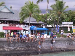
from the problems of the world. Most evenings local children fish
off the seawall (right) next to the Kailua Pier (the center of
K-K activities in its role as the sport fishing capital of the
islands); the area in front of the seawall (called "Dig Me"
beach) also acts as the starting point for the ocean swim leg
of the Ironman Triathlon World Championships, held every October
in K-K
The west, or Kona, coast of the BI
is the leeward side of the island; it gets very little rain and
lots of sunshine. The town of Kailua-Kona
sits in the middle of the coast, and also in the lee of Hualalai
where it's protected from the tradewinds as well as from the rain,
providing it with the best weather on the island. In K-K, the
'Ahu'ena Heiau (left), personal temple of King Kamehameha the
Great (who restored it in 1812), sits on an artificial island
off the end of Kumakahonu Beach (on the grounds of a hotel that
bears KK's name) - in the background is the Nane Mahina 'Ai, where
the King (who could have lived anywhere in the islands but chose
to live in K-K from 1812 till his death in 1819) went to retreat
from the problems of the world. Most evenings local children fish
off the seawall (right) next to the Kailua Pier (the center of
K-K activities in its role as the sport fishing capital of the
islands); the area in front of the seawall (called "Dig Me"
beach) also acts as the starting point for the ocean swim leg
of the Ironman Triathlon World Championships, held every October
in K-K
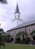
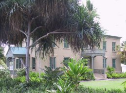
 Located about a block down from the
pier on Ali'i Drive is the Mokuaikaua Church (left; 1820), the
first Christian church built in the islands - originally a thatched
hut, the present lava rock and crushed coral structure was built
in 1836; the Huile'e Palace (right) is across the street (on the
ocean side of Ali'i) - built by Governor Kuakini in 1838, it was
a favorite among vacationing Hawaiian royalty (it's been a museum
since 1914)
Located about a block down from the
pier on Ali'i Drive is the Mokuaikaua Church (left; 1820), the
first Christian church built in the islands - originally a thatched
hut, the present lava rock and crushed coral structure was built
in 1836; the Huile'e Palace (right) is across the street (on the
ocean side of Ali'i) - built by Governor Kuakini in 1838, it was
a favorite among vacationing Hawaiian royalty (it's been a museum
since 1914)
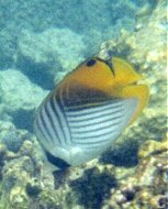
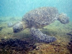
 About a mile or so south of "downtown"
K-K off Ali'i Drive, colorful schools of fish abound within the
protective reef of Kahalu'u Beach Park - including the Threadfin
Butterflyfish (left); a huge green sea turtle (spanning nearly
6 ft across the front flippers; right) ignored snorkelers while
feeding on the algae of the reef
About a mile or so south of "downtown"
K-K off Ali'i Drive, colorful schools of fish abound within the
protective reef of Kahalu'u Beach Park - including the Threadfin
Butterflyfish (left); a huge green sea turtle (spanning nearly
6 ft across the front flippers; right) ignored snorkelers while
feeding on the algae of the reef
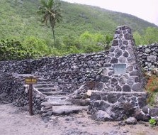
 Kealakekua (of "Little Grass Shack"
fame) is located ca 11 mi down the Kona Coast from K-K - its nearly
circular bay, a mile wide and home to a multitude of spinner dolphins,
is one of the most popular snorkeling venues on the BI, in spite
of the fact that the sands of Napo'opo'o Beach have totally eroded
away and been replaced by boulders (left); the Hiki-au Heiau (center),
a luakini temple to the warrior god Ku where human sacrifices
were performed, stands on its southern shore; on the opposite
side of the bay, an obelisk (right) stands near the spot where
Captain Cook was killed by locals in 1779 - the CC Monument occupies
British soil, deeded to the UK by Princess Likelike
Kealakekua (of "Little Grass Shack"
fame) is located ca 11 mi down the Kona Coast from K-K - its nearly
circular bay, a mile wide and home to a multitude of spinner dolphins,
is one of the most popular snorkeling venues on the BI, in spite
of the fact that the sands of Napo'opo'o Beach have totally eroded
away and been replaced by boulders (left); the Hiki-au Heiau (center),
a luakini temple to the warrior god Ku where human sacrifices
were performed, stands on its southern shore; on the opposite
side of the bay, an obelisk (right) stands near the spot where
Captain Cook was killed by locals in 1779 - the CC Monument occupies
British soil, deeded to the UK by Princess Likelike
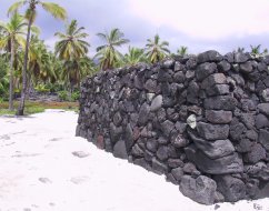
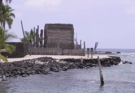
 A few miles down the coast at Honaunau
Bay (which also has great snorkeling once you can get past its
sharp black lava shores to the water), the main attraction is
Pu'uhonua o Honaunau (a National Historic Park since 1961); its
most impressive feature is the Great Wall (left), built in ca
1550 - 1000 ft long, 10 ft high, and 17 ft thick (right), it runs
perpendicular to the shore, separating the palace grounds of the
ali'i (royal chiefs, in this case, of Kona) from the pu'uhonua,
or "place of refuge." The refuge offered safety to warriors
defeated in battle and absolution to those who had broken the
kapu (taboos rooted in the ancient Hawaiian religion that regulated
every aspect of Hawaiian life) - if they could reach it; otherwise,
they died!
A few miles down the coast at Honaunau
Bay (which also has great snorkeling once you can get past its
sharp black lava shores to the water), the main attraction is
Pu'uhonua o Honaunau (a National Historic Park since 1961); its
most impressive feature is the Great Wall (left), built in ca
1550 - 1000 ft long, 10 ft high, and 17 ft thick (right), it runs
perpendicular to the shore, separating the palace grounds of the
ali'i (royal chiefs, in this case, of Kona) from the pu'uhonua,
or "place of refuge." The refuge offered safety to warriors
defeated in battle and absolution to those who had broken the
kapu (taboos rooted in the ancient Hawaiian religion that regulated
every aspect of Hawaiian life) - if they could reach it; otherwise,
they died!
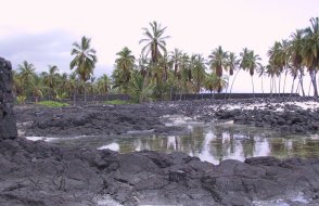
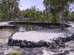
 The Park also contains other ancient
stone structures, like the heleipalala (left), a combination salt-
and freshwater pond where food fish were kept for the ali'i, as
well as restorations of structures such as the Hale o Keawe temple
(right; the original was built ca 1650 to honor Kamehameha's great-grandfather
Keawa'ikekahiali'i), which also served as a mausoleum, with its
tall wooden ki'i (carved images of the gods) standing watch over
many sets of ali'i bones
The Park also contains other ancient
stone structures, like the heleipalala (left), a combination salt-
and freshwater pond where food fish were kept for the ali'i, as
well as restorations of structures such as the Hale o Keawe temple
(right; the original was built ca 1650 to honor Kamehameha's great-grandfather
Keawa'ikekahiali'i), which also served as a mausoleum, with its
tall wooden ki'i (carved images of the gods) standing watch over
many sets of ali'i bones
 The Kohala Coast north of K-K is a
windy and barren lava desert that sits in the lee of the BI's
oldest volcano, 5500-ft high Kohala (on the northern tip of the
island, it last erupted ca 120,000 years ago). However its southern
half is also called the Gold Coast because of its many luxury
hotels and resorts - with lavish grass-covered grounds, palm trees,
flowers, and manicured golf courses, they stand out like oases
in a sea of rough black lava.
[The Big Island was once divided into
six major districts (counterclockwise, from the northern tip)
- Kohala and Kona in the west, Ka'u in the south, Puna in the
east, and Hilo and Hamakua in the northeast (guidebooks usually
divide Kohala, Kona, and Hilo into north and south districts as
well). While the King held ultimate authority over all the land,
he passed that authority to the ali'i (royal chiefs) of the 6
districts, who in turn passed it down to overseers (konahiki)
of wedge-shaped subdivisions (ahupua'a) that ran in a mauka-makai
direction (from the sea to the mountaintop).]
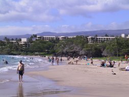
About 30 miles north of K-K, the Hapuna
Beach State Recreation Area, encompassing 61 acres, boasts a 1/2-mile
long, 200 ft wide crescent of sand (left; with the Westin HB Prince
Hotel in the background) that's consistently rated one of the
best in America. Further down the KC, in the middle of the Waikoloa
resort area, a short segment of the Mamalahoa Trail (center),
built in the mid-19th century by Hawaiian "labor tax"
workers, crosses a lava field - used primarily by horses and pack
animals, it overlaps the much older Ala Loa (King's Trail), a
coastal, round-the-island footpath constructed in the early 15th
century during the reign of Umi a Liloa after he united the BI
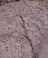
into one kingdom. Near the trail, the reddish pahoehoe lava field
of the Waikoloa Petroglyph Preserve contains hundreds of rock
carvings (right), made over the time period 1400-1800 (a few miles
north, there's an even more extensive collection of carvings at
the Malama Petroglyph Trail on the north side of the Mauna Lani
resort area)
The Kohala Coast north of K-K is a
windy and barren lava desert that sits in the lee of the BI's
oldest volcano, 5500-ft high Kohala (on the northern tip of the
island, it last erupted ca 120,000 years ago). However its southern
half is also called the Gold Coast because of its many luxury
hotels and resorts - with lavish grass-covered grounds, palm trees,
flowers, and manicured golf courses, they stand out like oases
in a sea of rough black lava.
[The Big Island was once divided into
six major districts (counterclockwise, from the northern tip)
- Kohala and Kona in the west, Ka'u in the south, Puna in the
east, and Hilo and Hamakua in the northeast (guidebooks usually
divide Kohala, Kona, and Hilo into north and south districts as
well). While the King held ultimate authority over all the land,
he passed that authority to the ali'i (royal chiefs) of the 6
districts, who in turn passed it down to overseers (konahiki)
of wedge-shaped subdivisions (ahupua'a) that ran in a mauka-makai
direction (from the sea to the mountaintop).]
About 30 miles north of K-K, the Hapuna
Beach State Recreation Area, encompassing 61 acres, boasts a 1/2-mile
long, 200 ft wide crescent of sand (left; with the Westin HB Prince
Hotel in the background) that's consistently rated one of the
best in America. Further down the KC, in the middle of the Waikoloa
resort area, a short segment of the Mamalahoa Trail (center),
built in the mid-19th century by Hawaiian "labor tax"
workers, crosses a lava field - used primarily by horses and pack
animals, it overlaps the much older Ala Loa (King's Trail), a
coastal, round-the-island footpath constructed in the early 15th
century during the reign of Umi a Liloa after he united the BI
into one kingdom. Near the trail, the reddish pahoehoe lava field
of the Waikoloa Petroglyph Preserve contains hundreds of rock
carvings (right), made over the time period 1400-1800 (a few miles
north, there's an even more extensive collection of carvings at
the Malama Petroglyph Trail on the north side of the Mauna Lani
resort area)
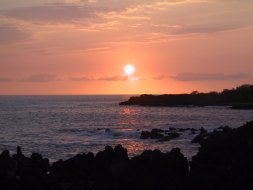
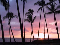
 The Kona Coast has spectacular sunsets,
as seen from the barren lava of Kuamo'o Point (left; site of a
ferocious battle instigated by Kamehameha II - King Liholiho -
in 1820 that led to the abolishment of the kapu system), and through
the coconut palms of Kahalu'u Beach (right)
The Kona Coast has spectacular sunsets,
as seen from the barren lava of Kuamo'o Point (left; site of a
ferocious battle instigated by Kamehameha II - King Liholiho -
in 1820 that led to the abolishment of the kapu system), and through
the coconut palms of Kahalu'u Beach (right)
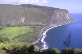
 At the start of the Hamakua Coast on
the eastern (Hilo; windward, and very wet) side of the island,
at the end of a side road off the coast highway near the town
of Honoka'a, an overlook (ca 50 mi north of Hilo) provides a view
of the spectacular Waipi'o Valley (left), the largest and southernmost
of the 7 remote valleys on the east side of the Kohala Volcano.
The valley is a mile wide at the coast - which is rimmed by a
spectacular black-sand beach - and almost 6 miles deep, with waterfall-lined
cliffs on either side towering to almost 2000 ft; the valley can
only be accessed from the ocean, or from a one-lane road that
drops down from the overlook on a 25% grade. Once the home of
BI's rulers, the 'Valley of the Kings' contains seven heiaus -
including the luakini Paka'alana that was also the site of the
other major pu'uhonau on the BI. Now home to a handful of taro
farmers and wild horses (along with Kaluahina Falls, the latter
were featured in the closing scenes of Kevin Costner's 'Waterworld'),
it held a population of ca 3000 in 1778, ca 200 into modern times
until a 30-ft high wall of water from a 1946 tsunami swept several
miles up the valley. While the April 1, 1946 tsunami (started
by an earthquake in the Aleutian Islands) somehow spared the people
of Waipi'o, at Laupahoehoe ("lava leaf") Point (right;
located ca 20 mi north of Hilo) it was not so kind, killing twenty-four
people, including sixteen students and five teachers at the local
school; once the main shipping harbor on the BI, the townsite
is now on the cliffs above and only a shattered pier and a monument
to the dead indicate its past
At the start of the Hamakua Coast on
the eastern (Hilo; windward, and very wet) side of the island,
at the end of a side road off the coast highway near the town
of Honoka'a, an overlook (ca 50 mi north of Hilo) provides a view
of the spectacular Waipi'o Valley (left), the largest and southernmost
of the 7 remote valleys on the east side of the Kohala Volcano.
The valley is a mile wide at the coast - which is rimmed by a
spectacular black-sand beach - and almost 6 miles deep, with waterfall-lined
cliffs on either side towering to almost 2000 ft; the valley can
only be accessed from the ocean, or from a one-lane road that
drops down from the overlook on a 25% grade. Once the home of
BI's rulers, the 'Valley of the Kings' contains seven heiaus -
including the luakini Paka'alana that was also the site of the
other major pu'uhonau on the BI. Now home to a handful of taro
farmers and wild horses (along with Kaluahina Falls, the latter
were featured in the closing scenes of Kevin Costner's 'Waterworld'),
it held a population of ca 3000 in 1778, ca 200 into modern times
until a 30-ft high wall of water from a 1946 tsunami swept several
miles up the valley. While the April 1, 1946 tsunami (started
by an earthquake in the Aleutian Islands) somehow spared the people
of Waipi'o, at Laupahoehoe ("lava leaf") Point (right;
located ca 20 mi north of Hilo) it was not so kind, killing twenty-four
people, including sixteen students and five teachers at the local
school; once the main shipping harbor on the BI, the townsite
is now on the cliffs above and only a shattered pier and a monument
to the dead indicate its past
 The Hilo coast of the BI gets all the
rainfall that the Kona Coast lacks, that is, ca 140 inches per
year. As a result, the Hilo side of the island is very wet, with
huge waterfalls "everywhere." It is also very green,
with an abundance of nearly every variety of tropical plant, native
or otherwise, in its parks, botanical gardens, or nurseries.
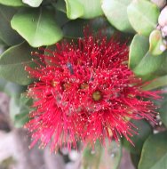
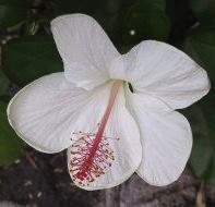
Triple-tiered, 300-ft high Umauma Falls
(left) is the centerpiece of the recently established (1995) World
Botanic Garden. Although the plantings are extensive, with 5,000
species supposedly represented, most are still in a nascent stage,
ie, the Garden looks relatively barren in most spots, native plants
are abundant - the red lehua blossom of the Ohi'a tree (center),
official flower of the BI; a native white hibiscus (right)
The Hilo coast of the BI gets all the
rainfall that the Kona Coast lacks, that is, ca 140 inches per
year. As a result, the Hilo side of the island is very wet, with
huge waterfalls "everywhere." It is also very green,
with an abundance of nearly every variety of tropical plant, native
or otherwise, in its parks, botanical gardens, or nurseries.
Triple-tiered, 300-ft high Umauma Falls
(left) is the centerpiece of the recently established (1995) World
Botanic Garden. Although the plantings are extensive, with 5,000
species supposedly represented, most are still in a nascent stage,
ie, the Garden looks relatively barren in most spots, native plants
are abundant - the red lehua blossom of the Ohi'a tree (center),
official flower of the BI; a native white hibiscus (right)
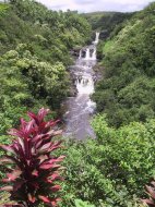
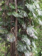
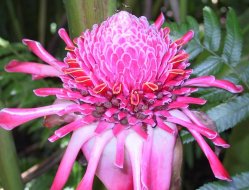
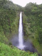
 About 12 miles north of Hilo in the
highlands above the town of Honomu, a short trail leads to Hawaii's
highest (easily accessible) waterfall, on Kolekole Stream, passing
through a lush tropical forest hung with giant philodendron vines
- like this split-leaf (left) completely covering a tree, stands
of bamboo, 20-ft high torch ginger - topped with huge blossoms
(center), and an understory of lush ferns studded with impatiens
and wild orchids. After passing 100-ft high Kahuna Falls as a
warm-up, the trail eventually leads the visitor to the spectacular
plunge of 442-ft high Akaka Falls (right)
About 12 miles north of Hilo in the
highlands above the town of Honomu, a short trail leads to Hawaii's
highest (easily accessible) waterfall, on Kolekole Stream, passing
through a lush tropical forest hung with giant philodendron vines
- like this split-leaf (left) completely covering a tree, stands
of bamboo, 20-ft high torch ginger - topped with huge blossoms
(center), and an understory of lush ferns studded with impatiens
and wild orchids. After passing 100-ft high Kahuna Falls as a
warm-up, the trail eventually leads the visitor to the spectacular
plunge of 442-ft high Akaka Falls (right)
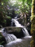
 Further down the coast, about 9 miles
north of Hilo off a short scenic drive, the older Hawaiian Tropical
Botanic Garden, which opened to the public in 1984, sits on a
steep hillside above Onomea Bay; while the 40-acre Garden is located
in a spectacular setting and contains the picturesque Onomea Falls
(left), its real attraction is its mature plant collection, representing
over 2,000 species from more than 125 families and 750 genera,
assembled by owner and founder Dan Lutkenhouse and his staff over
a 25 year period (the Garden is now a non-profit corporation)
- red ginger (left center); a yellow Oncidium, or Dancing Lady,
orchid (right center); a dwarf pineapple (right)
Further down the coast, about 9 miles
north of Hilo off a short scenic drive, the older Hawaiian Tropical
Botanic Garden, which opened to the public in 1984, sits on a
steep hillside above Onomea Bay; while the 40-acre Garden is located
in a spectacular setting and contains the picturesque Onomea Falls
(left), its real attraction is its mature plant collection, representing
over 2,000 species from more than 125 families and 750 genera,
assembled by owner and founder Dan Lutkenhouse and his staff over
a 25 year period (the Garden is now a non-profit corporation)
- red ginger (left center); a yellow Oncidium, or Dancing Lady,
orchid (right center); a dwarf pineapple (right)
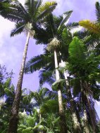
 More Garden sights - the hanging bract
of a Heliconia (left); an Anthurium (center); a stand of lofty
king palms, natives of Australia (right)
More Garden sights - the hanging bract
of a Heliconia (left); an Anthurium (center); a stand of lofty
king palms, natives of Australia (right)

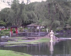
 Hilo itself is a mix of the old and
the new. After its devastation by a tsunami (over 100 deaths,
more than $20 million in damage) in 1946 and another on May 22,
1960 (waves up to 35 ft high, whole city blocks swept clean of
buildings, 61 deaths, over $50 million in damage), Hilo designated
areas near its bayfront for parks, beaches, and open space. Lili'uokalani
Park (left) is a 30-acre Japanese-style garden located on a peninsula
in Hilo Bay (on land donated by the Queen), right next to Hilo's
hotel row. Coconut Island (right), which sits a few hundred yards
out in Hilo Bay, is connected to the shore by a long footbridge
- its traditional name, Moku Ola, means "Healing Island";
in ancient times it was a pu'uhonua
Hilo itself is a mix of the old and
the new. After its devastation by a tsunami (over 100 deaths,
more than $20 million in damage) in 1946 and another on May 22,
1960 (waves up to 35 ft high, whole city blocks swept clean of
buildings, 61 deaths, over $50 million in damage), Hilo designated
areas near its bayfront for parks, beaches, and open space. Lili'uokalani
Park (left) is a 30-acre Japanese-style garden located on a peninsula
in Hilo Bay (on land donated by the Queen), right next to Hilo's
hotel row. Coconut Island (right), which sits a few hundred yards
out in Hilo Bay, is connected to the shore by a long footbridge
- its traditional name, Moku Ola, means "Healing Island";
in ancient times it was a pu'uhonua
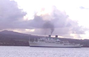
 The SS Independence (completed in 1951,
extensively refitted in 1994), an American Hawaiian cruise ship
in inter-island service, steams out of Hilo Bay, with Mauna Kea
in the background; AHC filed for bankruptcy at the end of 2001,
and the Independence stopped sailing the following year
The SS Independence (completed in 1951,
extensively refitted in 1994), an American Hawaiian cruise ship
in inter-island service, steams out of Hilo Bay, with Mauna Kea
in the background; AHC filed for bankruptcy at the end of 2001,
and the Independence stopped sailing the following year
 Go to Hawai'i-1
| Return to Home Page
Go to Hawai'i-1
| Return to Home Page