JOHN DAY FOSSIL BEDS
(Last updated 8/26/02)
Located on the high volcanic plateau
of north central Oregon, the John Day Fossil Beds National Monument
(established by Congress in 1975) consists of three widely separated
"units" encompassing 14,000 acres in the badlands of
the middle John Day basin. Taken together, the fossils from these
three small areas, spanning the period from ca. 5 to 55 million
years ago, provide the most complete record of the Cenozoic Era
- the age of flowering plants and mammals - in the world.
The John Day River (JDR) and its many
small tributaries, fed by snows from the Blue Mountains to the
northeast and the Ochocos to the southwest, are both the architect
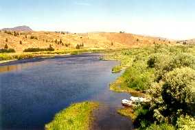
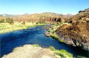
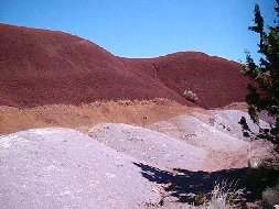
and the lifeblood of this semi-arid region. The Clarno Recreation
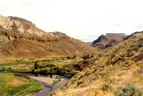
Site (left; located about 15 mi east of Antelope
on Hwy 218) marks the end of the section of the JDR designated
as "Wild and Scenic," and is a convenient take-out point
for rafters, many of whom may have drifted for several days down
the JDR's meandering course. The Clarno Unit of the JDFB (right),
another 5 miles east, contains the oldest layer of rock in the
basin, the Clarno Formation, which consists of thick volcanic
basalts topped by a few hundred feet of volcanic ash, and actually
covers an area west to the foothills of the eastern Cascades,
north nearly to the Columbia, and south beyond the Crooked River
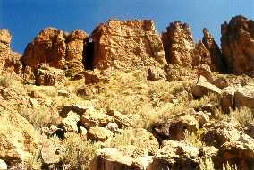
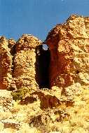
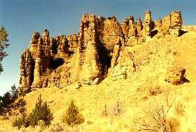
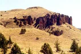
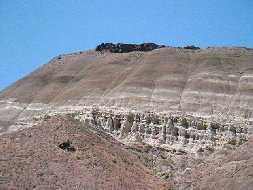
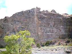
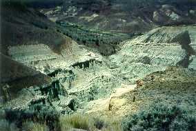
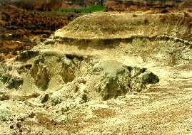
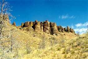 The cliffs of the Clarno Unit are the
remnants of a series of lahars, gigantic mudflows of CF ash that
rolled down the slopes of nearby volcanoes and inundated the low-lying
forests, preserving fossilized wood, leaves, nuts, and seeds from
the Late Eocene to Early Oligocene period - ca. 37 to 55 million
years ago. Here the cliffs have been transformed by water, wind,
and ice into castle-like forms that dominate the skyline
The cliffs of the Clarno Unit are the
remnants of a series of lahars, gigantic mudflows of CF ash that
rolled down the slopes of nearby volcanoes and inundated the low-lying
forests, preserving fossilized wood, leaves, nuts, and seeds from
the Late Eocene to Early Oligocene period - ca. 37 to 55 million
years ago. Here the cliffs have been transformed by water, wind,
and ice into castle-like forms that dominate the skyline
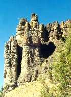
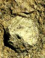
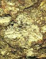
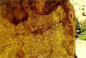
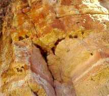
 The elements have also exposed the
richness of the area's fossil content. A fossil nut (left) and
the veined imprint of a fossil leaf (center) mark the surface
of one of the fallen chunks of rock that litter the slope below
the cliffs; the leaf is large, with a non-serrated edge, typical
of the fig, sycamore, laurel, and palm-like flora from this subtropical
era, populated by many extinct lines of mammals - browsing amynodonts,
brontotheres, and titanotheres, and meat-eating creodonts - and
also by crocodiles, amphibious rhinoceroses, primitive tapirs,
and tiny horses. A huge standing boulder (right) displays the
dark red arc of an ancient branch embedded in its shoulder
The elements have also exposed the
richness of the area's fossil content. A fossil nut (left) and
the veined imprint of a fossil leaf (center) mark the surface
of one of the fallen chunks of rock that litter the slope below
the cliffs; the leaf is large, with a non-serrated edge, typical
of the fig, sycamore, laurel, and palm-like flora from this subtropical
era, populated by many extinct lines of mammals - browsing amynodonts,
brontotheres, and titanotheres, and meat-eating creodonts - and
also by crocodiles, amphibious rhinoceroses, primitive tapirs,
and tiny horses. A huge standing boulder (right) displays the
dark red arc of an ancient branch embedded in its shoulder
 Black dots, actually the mud nests
of swallows, line the recesses (left) of ancient rocks
Black dots, actually the mud nests
of swallows, line the recesses (left) of ancient rocks
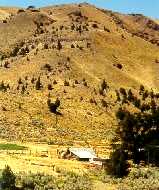
 punctuated by the existence of solitary
ranches
punctuated by the existence of solitary
ranches
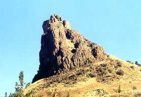
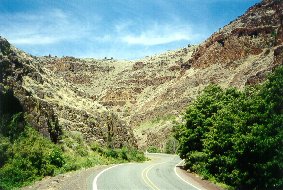
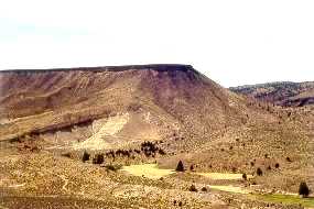
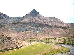
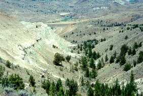
 About halfway to the Painted Hills
Unit (which is ca. 50 miles southeast of the CU), a break in the
river's canyon walls near the mouth of Service Creek (left) provides
excellent access to the JDR, and is a popular departure point
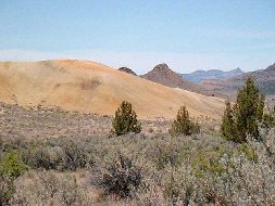
for rafters and fishermen. Mitchell Rock (right), an old volcanic
plug from the CF era located just a few miles from the PHU, is
about a mile west of the town of Mitchell (an excellent base from
which to explore all three JDFB units) on Hwy 26
About halfway to the Painted Hills
Unit (which is ca. 50 miles southeast of the CU), a break in the
river's canyon walls near the mouth of Service Creek (left) provides
excellent access to the JDR, and is a popular departure point
for rafters and fishermen. Mitchell Rock (right), an old volcanic
plug from the CF era located just a few miles from the PHU, is
about a mile west of the town of Mitchell (an excellent base from
which to explore all three JDFB units) on Hwy 26
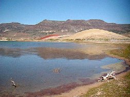
 The entrance to the PHU is reached
from Hwy 26 on a six mile access road that parallels Cherry Creek
- the road passes several sites that provide a hint (left) of
sights to come; just outside the PHU proper, a view across the
Cherry Creek Ranch reservoir (right), with the ridgeline of Sutton
Mountain in the background, the latter capped with layers of 16
million year old (myo) flood basalts
The entrance to the PHU is reached
from Hwy 26 on a six mile access road that parallels Cherry Creek
- the road passes several sites that provide a hint (left) of
sights to come; just outside the PHU proper, a view across the
Cherry Creek Ranch reservoir (right), with the ridgeline of Sutton
Mountain in the background, the latter capped with layers of 16
million year old (myo) flood basalts
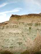
 Carroll Ridge (left) is located near
the entrance to the PHU; the plateau at its top is capped with
a 29 myo layer of welded volcanic tuff, or ignimbrite, while its
base is from the John
Day Formation, a layer of hardened volcanic ash 37 myo. Leaf
Hill (right, foreground), a small, inconspicuous mound of 33 myo
shale along a short loop trail lined with junipers at the far
end of the PHU, has yielded plant fossils representing 35 species,
including broad-leaved deciduous types such as alder, beech, maple,
and an extinct hornbeam, as well as rose, oak, grape, elm, a fern,
and conifers such as the dawn redwood
Carroll Ridge (left) is located near
the entrance to the PHU; the plateau at its top is capped with
a 29 myo layer of welded volcanic tuff, or ignimbrite, while its
base is from the John
Day Formation, a layer of hardened volcanic ash 37 myo. Leaf
Hill (right, foreground), a small, inconspicuous mound of 33 myo
shale along a short loop trail lined with junipers at the far
end of the PHU, has yielded plant fossils representing 35 species,
including broad-leaved deciduous types such as alder, beech, maple,
and an extinct hornbeam, as well as rose, oak, grape, elm, a fern,
and conifers such as the dawn redwood
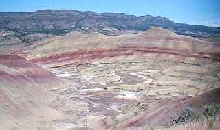
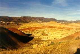
 A daylight view of the Painted Hills
basin from the Overlook Trail...
A daylight view of the Painted Hills
basin from the Overlook Trail...
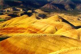
 ...and again as the sun sets...
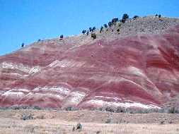
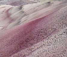
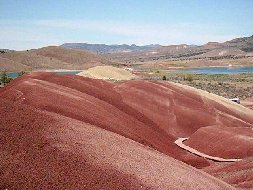
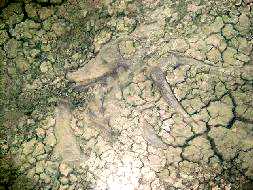
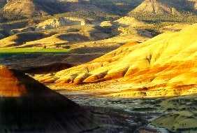 Painted Cove - the colored hills remain
barren as their clays absorb and lock up all available moisture
Painted Cove - the colored hills remain
barren as their clays absorb and lock up all available moisture
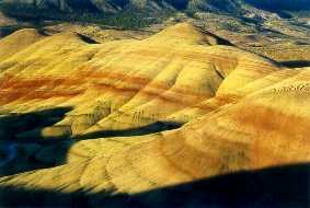
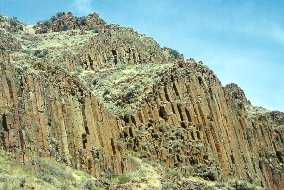
 The eastern end of Picture Gorge (left),
cut by the waters of Rock Creek, a major tributary of the JDR,
features 16 myo basalts, include huge swaths of the columnar variety
(right)
The eastern end of Picture Gorge (left),
cut by the waters of Rock Creek, a major tributary of the JDR,
features 16 myo basalts, include huge swaths of the columnar variety
(right)
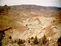
 The waters of the upper JDR (left)
have cut the southeastern end of Picture Gorge; just south of
the Gorge, a ridge overlook provides a view of the 12-15 myo Mascall
Formation (right), topped by a thin layer of the 6-8 myo Rattlesnake
Formation
The waters of the upper JDR (left)
have cut the southeastern end of Picture Gorge; just south of
the Gorge, a ridge overlook provides a view of the 12-15 myo Mascall
Formation (right), topped by a thin layer of the 6-8 myo Rattlesnake
Formation
 Sheep Rock (left) is located on the
JDR at the southern end of its namesake Unit; Goose Rock (right),
further north, is an anomaly even in this region, an ancient conglomerate
of 100 myo rocks and pebbles deposited at the mouth of a large
river that ended on the shore of the sea that covered this part
of Oregon in the Mesozoic Era (age of reptiles)
Sheep Rock (left) is located on the
JDR at the southern end of its namesake Unit; Goose Rock (right),
further north, is an anomaly even in this region, an ancient conglomerate
of 100 myo rocks and pebbles deposited at the mouth of a large
river that ended on the shore of the sea that covered this part
of Oregon in the Mesozoic Era (age of reptiles)
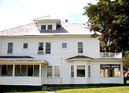
 The James Cant Ranch House, built in
1917, now houses the Visitor's Center (left); heading up the Blue
Basin Overlook Trail (right) just to the north
The James Cant Ranch House, built in
1917, now houses the Visitor's Center (left); heading up the Blue
Basin Overlook Trail (right) just to the north
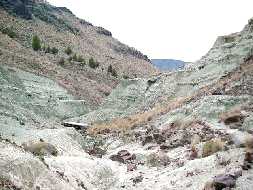
 Views of the Blue Basin from the Overlook
Trail
Views of the Blue Basin from the Overlook
Trail
 At ground level on the Island of Time
trail, the Blue Basin itself (left) appears unremarkable, until
one sees 30 myo bones (right) that still lie undisturbed
At ground level on the Island of Time
trail, the Blue Basin itself (left) appears unremarkable, until
one sees 30 myo bones (right) that still lie undisturbed
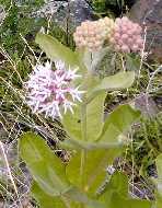
 Showy Milkweed (left), one of the many
unusual wildflowers that bloom in this area; views (center, right)
along the Foree area Flood of Fire trail further north in the
SRU
Showy Milkweed (left), one of the many
unusual wildflowers that bloom in this area; views (center, right)
along the Foree area Flood of Fire trail further north in the
SRU
 Return to
Home Page
Return to
Home Page