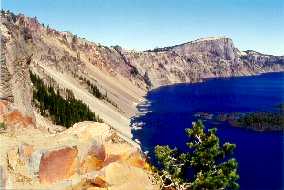
CRATER LAKE
(Last updated 1/28/06)
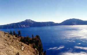
Located near the southern end of Oregon's
High Cascades, Crater Lake National Park, 
the nation's 5th oldest (1902), was the culmination of a 17-year
long lobbying effort by William G. Steel, who became fascinated
with the lake as a Kansas schoolboy, then spent most of his adult
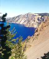
life fighting for its preservation. The nearly circular lake,
ca. 5 miles N-S by 6 miles E-W, is actually a caldera basin, formed
about 7,700 years ago by the collapse of the top 5,000 ft of Mt.
Mazama (once 12,000 ft high) after it erupted cataclysmically,
spewing out nearly 12 cubic miles of material in a few days (the
largest eruption ever in the Cascade Range, over 40 times greater
than that of St. Helens in 1980). Although it has no outlets or
inlets, over time the caldera filled with water, and eventually
a balance was achieved between precipitation falling into the
lake and evaporation -- its level (usually cited as 6,176 ft)
has fluctuated by less than 15 ft in the past 100 years. At 1,932
ft, the lake is the deepest in North America (average depth 1,500
ft), and seventh deepest in the world; its clarity, at 134 ft
(1994), is also a record
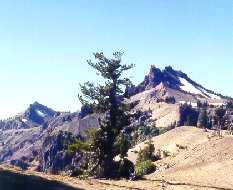
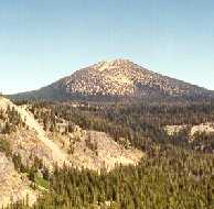
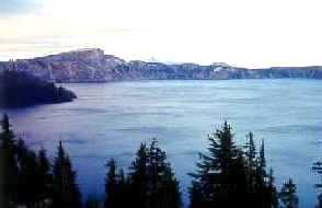
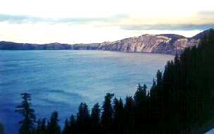
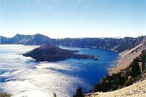 A number of Cascade peaks can be seen
from the lake rim's lofty height (which averages 7,100 ft) - about
15 miles to the north, from left to right: Mt. Bailey (8,363 ft);
Diamond Peak (8,750 ft; ca. 25 miles further north) with Diamond
Lake just visible in front of it; Red Cone (7,363) in the center
foreground with the Three Sisters (almost 90 miles north) barely
visible behind and to the right; and Mt. Thielsen (9,182 ft; an
eroded volcanic plug), behind the barren ash layer of the Pumice
Desert
A number of Cascade peaks can be seen
from the lake rim's lofty height (which averages 7,100 ft) - about
15 miles to the north, from left to right: Mt. Bailey (8,363 ft);
Diamond Peak (8,750 ft; ca. 25 miles further north) with Diamond
Lake just visible in front of it; Red Cone (7,363) in the center
foreground with the Three Sisters (almost 90 miles north) barely
visible behind and to the right; and Mt. Thielsen (9,182 ft; an
eroded volcanic plug), behind the barren ash layer of the Pumice
Desert
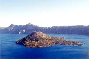
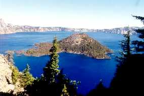
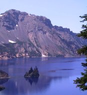
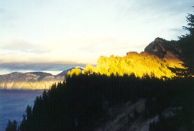
 Wizard Island (left), a classic cinder
cone that rose above water level only 800 years ago, is an indicator
of continued volcanic activity in the area (another is the Merriam
Cone, which rises 1,394 ft from the caldera floor, but is still
over 500 ft below the surface); just behind it on the rim are
The Watchman (8,013 ft) and Hillman Peak (8,151 ft). The latter
(right), the rim's highest point, is the remainder of one of Mazama's
many ancillary volcanoes, sliced in half by the caldera's collapse
Wizard Island (left), a classic cinder
cone that rose above water level only 800 years ago, is an indicator
of continued volcanic activity in the area (another is the Merriam
Cone, which rises 1,394 ft from the caldera floor, but is still
over 500 ft below the surface); just behind it on the rim are
The Watchman (8,013 ft) and Hillman Peak (8,151 ft). The latter
(right), the rim's highest point, is the remainder of one of Mazama's
many ancillary volcanoes, sliced in half by the caldera's collapse
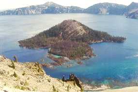
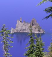
 Although it looks relatively small
when seen from the high rim walls, Wizard rises 764 ft above the
surface of the lake (the dark blue water in the foreground, left,
is Fumarole Bay). The crater at its top (right) is 300 ft wide
and 90 ft deep; the narrow passage between the island and the
shore is Skell Channel.
Although it looks relatively small
when seen from the high rim walls, Wizard rises 764 ft above the
surface of the lake (the dark blue water in the foreground, left,
is Fumarole Bay). The crater at its top (right) is 300 ft wide
and 90 ft deep; the narrow passage between the island and the
shore is Skell Channel.
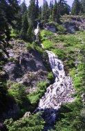
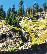
 East of the lake, a view of the partially
eroded volcanic cone of Mt. Scott (left; 8,929 ft), the highest
point in the Park; just south of Sun Notch on the south rim, the
100-ft multi-tiered Vidae Falls, the highest waterfall in the
park - normally a torrent (fed by melting snow) that pours into
Sun Creek in July (center), it's a mere trickle by late September
(right)
East of the lake, a view of the partially
eroded volcanic cone of Mt. Scott (left; 8,929 ft), the highest
point in the Park; just south of Sun Notch on the south rim, the
100-ft multi-tiered Vidae Falls, the highest waterfall in the
park - normally a torrent (fed by melting snow) that pours into
Sun Creek in July (center), it's a mere trickle by late September
(right)
 Crater Lake's Rim Drive (1918), ca.
33 miles long, is the result of another lobbying effort by William
Steel; it circles the lake, with most of it right on the rim,
providing continuously spectacular views. Looking past Hillman
Peak, a view of layered Llao Rock (left; ca. 8,000 ft; 1,870 ft
above the lake's surface) from the shoulder of The Watchman; looking
past the Pumice Castle, a view of Cloudcap (right; 7,960 ft),
the highest point on the east rim
Crater Lake's Rim Drive (1918), ca.
33 miles long, is the result of another lobbying effort by William
Steel; it circles the lake, with most of it right on the rim,
providing continuously spectacular views. Looking past Hillman
Peak, a view of layered Llao Rock (left; ca. 8,000 ft; 1,870 ft
above the lake's surface) from the shoulder of The Watchman; looking
past the Pumice Castle, a view of Cloudcap (right; 7,960 ft),
the highest point on the east rim
 About 300 ft long and rising 160 ft
above water level, the vertical slab of dense andesitic lava known
as the Phantom Ship - perhaps the oldest rock in the caldera -
is a remnant of one of the many dikes formed by seepage through
cracks on Phantom Cone, a volcano that preceded Mazama. Its name
derives from the mast-like appearance of its spiny backbone, and
from its ability to disappear into the shadows at certain times
of the day
About 300 ft long and rising 160 ft
above water level, the vertical slab of dense andesitic lava known
as the Phantom Ship - perhaps the oldest rock in the caldera -
is a remnant of one of the many dikes formed by seepage through
cracks on Phantom Cone, a volcano that preceded Mazama. Its name
derives from the mast-like appearance of its spiny backbone, and
from its ability to disappear into the shadows at certain times
of the day
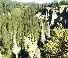
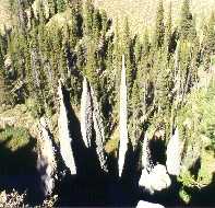
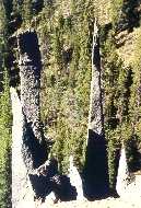
 About 6 miles southeast of the caldera,
The Pinnacles are eroded spires of cemented ash, some over 200
ft high, that mark post-eruption fumaroles - vents for the superheated
gasses trapped beneath the layers of pumice and scoria that flowed
from Mazama's eruption; the ones shown here line the rim of Sand
Creek
About 6 miles southeast of the caldera,
The Pinnacles are eroded spires of cemented ash, some over 200
ft high, that mark post-eruption fumaroles - vents for the superheated
gasses trapped beneath the layers of pumice and scoria that flowed
from Mazama's eruption; the ones shown here line the rim of Sand
Creek
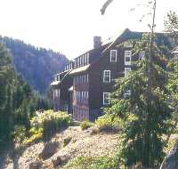
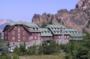
 Crater Lake Lodge (1909-15), another
Steel lobbying effort, sits right on the edge of the southwest
rim, ca. 900 ft above the lake. Built by a private developer in
1929, the National Park Service acquired it in 1967, closed it
in 1989 when the Great Hall Wing was declared unsafe, reopened
it in 1995 after extensive rebuilding
Crater Lake Lodge (1909-15), another
Steel lobbying effort, sits right on the edge of the southwest
rim, ca. 900 ft above the lake. Built by a private developer in
1929, the National Park Service acquired it in 1967, closed it
in 1989 when the Great Hall Wing was declared unsafe, reopened
it in 1995 after extensive rebuilding
 Views looking northeast from the back
terrace of the Lodge: (left) the protrusion on the far left is
Wizard Island, with Llao Rock visible on the rim behind; (right)
the prominent feature on the right is Cloudcap
Views looking northeast from the back
terrace of the Lodge: (left) the protrusion on the far left is
Wizard Island, with Llao Rock visible on the rim behind; (right)
the prominent feature on the right is Cloudcap
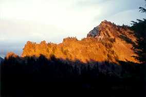
 The colors of sunset play out on Garfield
Peak (8,054 ft) just east of the Lodge, another spectacular feature
of the terrace view
The colors of sunset play out on Garfield
Peak (8,054 ft) just east of the Lodge, another spectacular feature
of the terrace view
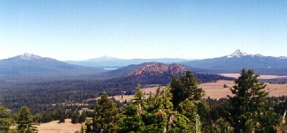
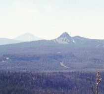
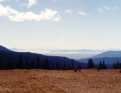
 More Cascade peaks are visible to the
south (left) from a viewpoint just above the Lodge: Union Peak
(7,698 ft; ca 8 miles away), with Mt. McLoughlin (9,496 ft; ca.
35 miles away) to its left; (right) just visible on the horizon
at far left behind Upper Klamath Lake (which lies ca. 12 miles
east of McLoughlin) is California's Mt. Shasta (14,161 ft; ca.
100 miles south of CL)
More Cascade peaks are visible to the
south (left) from a viewpoint just above the Lodge: Union Peak
(7,698 ft; ca 8 miles away), with Mt. McLoughlin (9,496 ft; ca.
35 miles away) to its left; (right) just visible on the horizon
at far left behind Upper Klamath Lake (which lies ca. 12 miles
east of McLoughlin) is California's Mt. Shasta (14,161 ft; ca.
100 miles south of CL)
 Return to
Home Page
Return to
Home Page