ENGLAND-1
(Last updated
2/5/05)
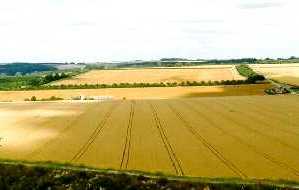
The Wiltshire/Salisbury chalk plains
(left), in Wessex, southwest England.
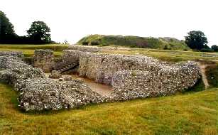
Old Sarum, the "original" Salisbury (from the Saxon
"searobyrg," meaning "dry town"), was built
on a chalk Iron Age hill fort (dating from about 500 BC), surrounded
by an outer earthen bank (flanked by inner and outer ditches)
over a mile in circumference. The pic (right) shows the ruins
of the original Cathedral (1075-92), located on the Outer Bailey;
the hill in the right background is the inner Norman motte-and-bailey
(ditch surrounding a mound) that held the much older Royal Castle
- e.g., used by William the Conqueror to review his troops in
1070.
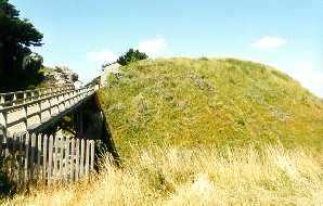
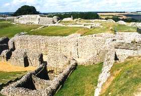
 Modern entrance to the Inner Bailey
(left) - the bridge passes over the old dry moat and thru the
chalk hill; overview from the top of the Inner Bailey (right)
- ruins of the Royal Palace (foreground), built for King Henry
I in the 1130's and used thru Tudor times, and of the much earlier
Great Tower and Postern Gate (left background), which guarded
the original entrance to the Inner Bailey.
Modern entrance to the Inner Bailey
(left) - the bridge passes over the old dry moat and thru the
chalk hill; overview from the top of the Inner Bailey (right)
- ruins of the Royal Palace (foreground), built for King Henry
I in the 1130's and used thru Tudor times, and of the much earlier
Great Tower and Postern Gate (left background), which guarded
the original entrance to the Inner Bailey.
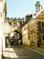
 Bishop Roger Poore ordered construction
of New Sarum (Salisbury) and its Cathedral in a fertile valley
a mile to the south of Old Sarum in 1220, after Old Sarum could
no longer support its population; Salisbury lies in Wiltshire
County, at the convergence of the (Wiltshire) Avon (Celtic for
river), Bourne, and Nadder Rivers. Section
of 14th c. city wall (left), built in parts with stones from Old
Sarum, including St. Anne's Gate (1331) at far left, southern
entrance to the old city; the chapel of the Vicar's Choral above
the Gate was the 1710 site of Handel's first concert in England.
High Street Gate (14th c.; right), the northern entrance of the
old city, connects the Constable's house and the Porter's Lodge
Bishop Roger Poore ordered construction
of New Sarum (Salisbury) and its Cathedral in a fertile valley
a mile to the south of Old Sarum in 1220, after Old Sarum could
no longer support its population; Salisbury lies in Wiltshire
County, at the convergence of the (Wiltshire) Avon (Celtic for
river), Bourne, and Nadder Rivers. Section
of 14th c. city wall (left), built in parts with stones from Old
Sarum, including St. Anne's Gate (1331) at far left, southern
entrance to the old city; the chapel of the Vicar's Choral above
the Gate was the 1710 site of Handel's first concert in England.
High Street Gate (14th c.; right), the northern entrance of the
old city, connects the Constable's house and the Porter's Lodge
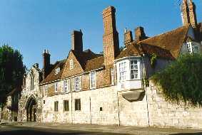
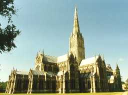
 Salisbury Cathedral (left), built 1220-58
in Early English Gothic style in the shape of a double cross,
is situated on a 30 acre expanse of green called the Cathedral
Close; its 404 ft spire (completed in 1315) is the tallest in
England. The 13th c Great Hall (right), with its 15th c three
story tower, was the residence of the Deans of Salisbury until
1922, is now part of the Diocesan Teacher Training College.
Salisbury Cathedral (left), built 1220-58
in Early English Gothic style in the shape of a double cross,
is situated on a 30 acre expanse of green called the Cathedral
Close; its 404 ft spire (completed in 1315) is the tallest in
England. The 13th c Great Hall (right), with its 15th c three
story tower, was the residence of the Deans of Salisbury until
1922, is now part of the Diocesan Teacher Training College.
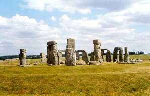
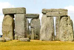
 About 12 miles to the north of Salisbury
lies Stonehenge, built in several ever more elaborate stages,
starting with the outer bank, which was dug around 3000 BC. The
outer Sarsen Circle and inner Horseshoe of five Sarsen Trilothons
were erected ca. 1500 BC, and are capped by lintel stones, held
in place by sophisticated mortise and tenon joints; the stones
(some weighing 50-60 tons) were moved to the site from the Marlborough
Downs, over 30 miles away. The inner circle of smaller bluestones
(which were brought from the Presili Mountains in southern Wales)
was erected around 2000 BC. The alignment of the Inner Horseshoe
with The Avenue and the Heal Stone coincides with the passage
of the sun and the passing of the seasons, showing a sophisticated
understanding of both mathematics and astronomy.
About 12 miles to the north of Salisbury
lies Stonehenge, built in several ever more elaborate stages,
starting with the outer bank, which was dug around 3000 BC. The
outer Sarsen Circle and inner Horseshoe of five Sarsen Trilothons
were erected ca. 1500 BC, and are capped by lintel stones, held
in place by sophisticated mortise and tenon joints; the stones
(some weighing 50-60 tons) were moved to the site from the Marlborough
Downs, over 30 miles away. The inner circle of smaller bluestones
(which were brought from the Presili Mountains in southern Wales)
was erected around 2000 BC. The alignment of the Inner Horseshoe
with The Avenue and the Heal Stone coincides with the passage
of the sun and the passing of the seasons, showing a sophisticated
understanding of both mathematics and astronomy.
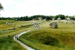
 About 25 miles to the north of Stonehenge
lies the Avebury Stone Circle, built ca. 2500 BC, the relatively
"new" part of a much larger complex of earthenworks,
"avenues," and barrows (tombs). The (Sarcen) stones
range from 10-13 ft high, weigh up to 35 tons, and, like those
at Stonehenge (which it preceded), came from the Marlborough Downs.
The purely ceremonial inside ditch (originally over 30 ft deep)
and bank circle are nearly a mile in circumference.
About 25 miles to the north of Stonehenge
lies the Avebury Stone Circle, built ca. 2500 BC, the relatively
"new" part of a much larger complex of earthenworks,
"avenues," and barrows (tombs). The (Sarcen) stones
range from 10-13 ft high, weigh up to 35 tons, and, like those
at Stonehenge (which it preceded), came from the Marlborough Downs.
The purely ceremonial inside ditch (originally over 30 ft deep)
and bank circle are nearly a mile in circumference.
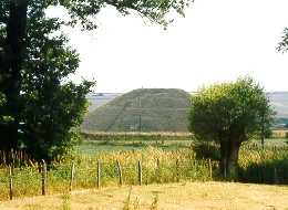
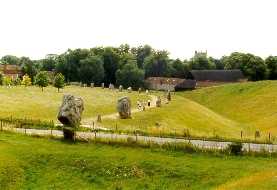 Less than a mile south of Avebury is
131 ft high Silbury Hill, Europe's largest prehistoric earthwork,
built (ca. 2750 BC) with chalk blocks excavated from the surrounding
ditch; covering about 5 acres, its flat top is large enough to
hold all of Stonehenge.
Less than a mile south of Avebury is
131 ft high Silbury Hill, Europe's largest prehistoric earthwork,
built (ca. 2750 BC) with chalk blocks excavated from the surrounding
ditch; covering about 5 acres, its flat top is large enough to
hold all of Stonehenge.
 The Georgian city of Bath lies to the
west of Avebury in Avon County. There were settlements in the
Bath area as early as 6000 BC; and the Romans established a town
there in 43 AD called Aquae Sulis. The medieval town of Bath was
the site of the coronation (973 AD) of the Saxon lord Edgar as
the first king of all England; later, Bath prospered as a wool
town. The present city was built in the early 1700's under the
direction of a businessman, Ralph Allen, to accomodate the hordes
of tourists who flocked to Bath after a visit by the "barren"
Queen Mary in 1687 - less than 10 months later she gave birth
to a son; that, and later visits by Queen Anne to "take the
waters," made it a fashionable place to visit. The early
city flourished under the direction of Richard "Beau"
Nash, elected Master of Ceremonies in 1704; he organized both
the city - installing lighting and banning swords to make the
streets safe - and the daily regimen of the aristocracy - with
balls, gambling, and concerts - to ensure a steady stream of visitors.
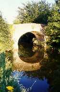
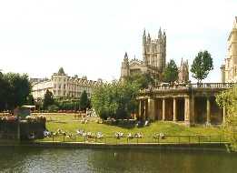
To the northwest of the city center,
an old stone bridge (left), reflected in the still waters of the
(Bristol) Avon, which nearly surrounds the city; flowers in Royal
Victoria Park (1830; right), just south and west of the Royal
Crescent (see below)
The Georgian city of Bath lies to the
west of Avebury in Avon County. There were settlements in the
Bath area as early as 6000 BC; and the Romans established a town
there in 43 AD called Aquae Sulis. The medieval town of Bath was
the site of the coronation (973 AD) of the Saxon lord Edgar as
the first king of all England; later, Bath prospered as a wool
town. The present city was built in the early 1700's under the
direction of a businessman, Ralph Allen, to accomodate the hordes
of tourists who flocked to Bath after a visit by the "barren"
Queen Mary in 1687 - less than 10 months later she gave birth
to a son; that, and later visits by Queen Anne to "take the
waters," made it a fashionable place to visit. The early
city flourished under the direction of Richard "Beau"
Nash, elected Master of Ceremonies in 1704; he organized both
the city - installing lighting and banning swords to make the
streets safe - and the daily regimen of the aristocracy - with
balls, gambling, and concerts - to ensure a steady stream of visitors.
To the northwest of the city center,
an old stone bridge (left), reflected in the still waters of the
(Bristol) Avon, which nearly surrounds the city; flowers in Royal
Victoria Park (1830; right), just south and west of the Royal
Crescent (see below)
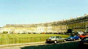
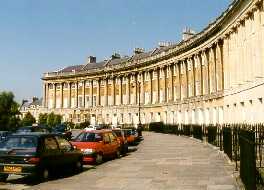
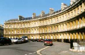
 Postcard view of the Royal Crescent,
top, and The Circus, connected by Brock Street (left); the Royal
Crescent (right), an arc of 33 Palladian-style townhouses, built
(1767-75) by local architect John Wood, Jr., and once called the
most majestic street in Britain. The Duke of York lived here in
the 18th c, as did the painter Gainsborough, in #17 - now, with
#16, the RC Hotel; the RC Museum occupies the rightmost unit -
#1; other townhouses are still privately owned
Postcard view of the Royal Crescent,
top, and The Circus, connected by Brock Street (left); the Royal
Crescent (right), an arc of 33 Palladian-style townhouses, built
(1767-75) by local architect John Wood, Jr., and once called the
most majestic street in Britain. The Duke of York lived here in
the 18th c, as did the painter Gainsborough, in #17 - now, with
#16, the RC Hotel; the RC Museum occupies the rightmost unit -
#1; other townhouses are still privately owned
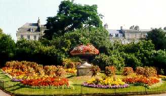
 Close-up of the Royal Crescent (left)
and of The Circus (right), a circular street of townhouses surrounding
a small park of trees and flowers - designed by both John Wood
Sr. and Jr.
Close-up of the Royal Crescent (left)
and of The Circus (right), a circular street of townhouses surrounding
a small park of trees and flowers - designed by both John Wood
Sr. and Jr.
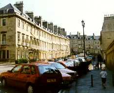
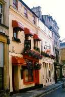
 Houses (left) on Gay Street to the
south; shops (center) and a church (right) from Georges Street
Houses (left) on Gay Street to the
south; shops (center) and a church (right) from Georges Street
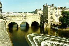
 The store-lined Pulteney Bridge (1769-74),
by Roger Adam (left), modeled after the Ponte Vecchio of Florence,
viewed from Grand Parade (right) - a weir is visible at lower
right, and an elaborate flood control system is hidden in the
channel behind the island at right center; punting on the (Bristol)
Avon, northeast of the city (right)
The store-lined Pulteney Bridge (1769-74),
by Roger Adam (left), modeled after the Ponte Vecchio of Florence,
viewed from Grand Parade (right) - a weir is visible at lower
right, and an elaborate flood control system is hidden in the
channel behind the island at right center; punting on the (Bristol)
Avon, northeast of the city (right)
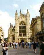
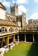
 After the seat of the See was moved
to Wells, Bath was downgraded from "city" (with a cathedral)
to "town" status, and the original, enormous Bath Cathedral
(from 1088) was replaced by the Abbey Church of St. Peter and
St. Paul (begun in 1499; Late Perpendicular Gothic style - seen
in all the pics). The entrance to the 1st c. Roman Baths is to
the right of the Abbey (center). The lead-lined Great Bath (right)
is surrounded by a 19th c. upper terrace - supported on columns
which sit in front of piers (see also below left) that supported
a barrel-vaulted roof during the four centuries of Roman use.
After the seat of the See was moved
to Wells, Bath was downgraded from "city" (with a cathedral)
to "town" status, and the original, enormous Bath Cathedral
(from 1088) was replaced by the Abbey Church of St. Peter and
St. Paul (begun in 1499; Late Perpendicular Gothic style - seen
in all the pics). The entrance to the 1st c. Roman Baths is to
the right of the Abbey (center). The lead-lined Great Bath (right)
is surrounded by a 19th c. upper terrace - supported on columns
which sit in front of piers (see also below left) that supported
a barrel-vaulted roof during the four centuries of Roman use.
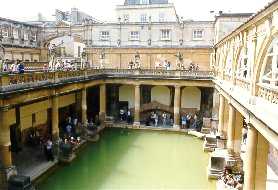
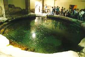
 Another view of the Great Bath (left)
- see the Roman roof arch at rear behind columns. The pool of
the Sacred Spring (right), now enclosed by the King's Bath, discharges
a constant 280,000 gallons of 116º F highly carbonated, sulfurous
water per day, unaffected by rainfall or longer-term climate changes.
Another view of the Great Bath (left)
- see the Roman roof arch at rear behind columns. The pool of
the Sacred Spring (right), now enclosed by the King's Bath, discharges
a constant 280,000 gallons of 116º F highly carbonated, sulfurous
water per day, unaffected by rainfall or longer-term climate changes.
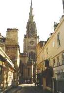
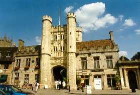
 City Gate of Wells, Somerset County
- the little "city" with a cathedral, southwest, and
on the other side of the Mendip Hills, from Bath
City Gate of Wells, Somerset County
- the little "city" with a cathedral, southwest, and
on the other side of the Mendip Hills, from Bath
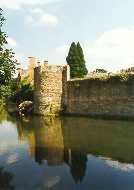
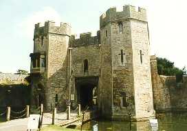
 The Bishop's Palace (begun in the 13th
c.), fortified with a turreted wall, moat, and drawbridge in the
14th c. after a quarrel between the Bishop and the town fathers:
the moat, supplied with water from the well of St. Andrew, and
turreted Palace wall (left); Gate House (center); Bishop's passageway
to the Cathedral (right)
The Bishop's Palace (begun in the 13th
c.), fortified with a turreted wall, moat, and drawbridge in the
14th c. after a quarrel between the Bishop and the town fathers:
the moat, supplied with water from the well of St. Andrew, and
turreted Palace wall (left); Gate House (center); Bishop's passageway
to the Cathedral (right)
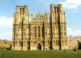
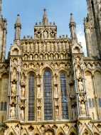
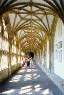 Wells Cathedral (left), built (12th
thru 14th c.) in the early English Gothic style, with stumpy towers;
its saving grace is the collection of over 300 elaborately carved
13th c. ecclesiastic statues which adorn the west front.
Wells Cathedral (left), built (12th
thru 14th c.) in the early English Gothic style, with stumpy towers;
its saving grace is the collection of over 300 elaborately carved
13th c. ecclesiastic statues which adorn the west front.
Interesting links:
Return to
Home Page