WALES
(Last updated 3/15/03)
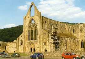
Tintern Abbey - in the Wye River Valley,
north of Chepstow, in the far southeast corner of Wales. Founded
in 1131 by Walter de Clare, Lord of Chepstow, and the Cistercian
(White) monks of Normandy; rebuilt in the 13th c (thru the 15th)
with help from Roger Bigod III, a later Chepstow Lord; dismantled
in 1536, then destroyed after the Dissolution of the Monasteries
decree by Henry VIII (as were all of the other abbeys in the country)
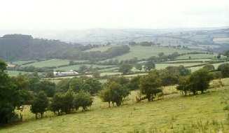
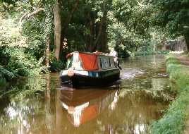
 View southwest of Abergavenny, near
Govilon, ca. 800 ft above the Usk Valley (left) in Brecon Beacons
National Park; vacation boat on the Monmouthshire and Brecon Canal
(built 1797-1812), which runs over Church Street in Govilon on
a stone aqueduct (right)
View southwest of Abergavenny, near
Govilon, ca. 800 ft above the Usk Valley (left) in Brecon Beacons
National Park; vacation boat on the Monmouthshire and Brecon Canal
(built 1797-1812), which runs over Church Street in Govilon on
a stone aqueduct (right)
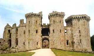
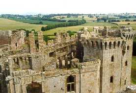
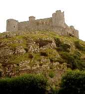
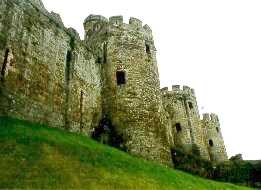
 Raglan Castle (15th-16th c.) - the
most elaborate of its era; construction was begun by Sir William
ap Thomas and completed primarily by his son William Herbert -
a Marcher Lord and the first Welshman admitted to the English
aristocracy. Herbert, the Yorkist earl of Pembroke, was beheaded
in 1496, and Raglan eventually passed to the earls of Worcester,
who rebuilt and enlarged it; a Royalist center, it fell after
an 11 week siege in 1646, marking the end of the first phase of
the Civil War.
Raglan Castle (15th-16th c.) - the
most elaborate of its era; construction was begun by Sir William
ap Thomas and completed primarily by his son William Herbert -
a Marcher Lord and the first Welshman admitted to the English
aristocracy. Herbert, the Yorkist earl of Pembroke, was beheaded
in 1496, and Raglan eventually passed to the earls of Worcester,
who rebuilt and enlarged it; a Royalist center, it fell after
an 11 week siege in 1646, marking the end of the first phase of
the Civil War.
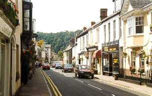
 Usk, an 18th c. market town built on
the site of the Roman outpost Burrium, predecessor of Isca (see
below) - street parking limits traffic, replete with huge lorries
and tour buses, to one lane on the already narrow highway (right)
Usk, an 18th c. market town built on
the site of the Roman outpost Burrium, predecessor of Isca (see
below) - street parking limits traffic, replete with huge lorries
and tour buses, to one lane on the already narrow highway (right)
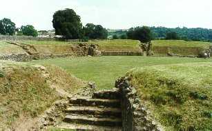
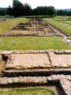
 Caerleon, northeast of Cardiff on the
Usk River: the Roman Amphitheater (80-100 AD; with seating for
6000), part of the Roman legionary fortress of Isca, base of the
Second Augustan Legion (left); also at Caerleon, the only remains
of a Roman legionary barracks in Europe (right)
Caerleon, northeast of Cardiff on the
Usk River: the Roman Amphitheater (80-100 AD; with seating for
6000), part of the Roman legionary fortress of Isca, base of the
Second Augustan Legion (left); also at Caerleon, the only remains
of a Roman legionary barracks in Europe (right)
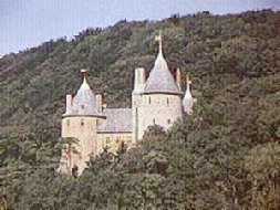
 Castell Coch ("Red Castle")
- north of Cardiff in the valley of the Taff River, on a cliff
above the village of Taff Wells (left); a triangle of connected
round towers built (1875-9) on the foundation of a massive 13th
c. red sandstone (hence the name) fortress for the 3rd Marquess
of Bute (then reputedly the richest man in the world) by the architect
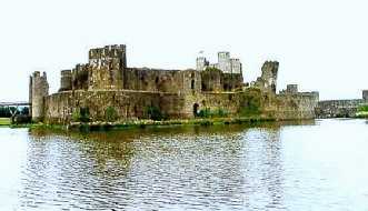
William Burgess. Caerphilly Castle (12th c.), the largest in Wales,
situated in a 15-acre lake created by damming the Nant-y-Gledr
(right); note the leaning (southeast) drum tower, casualty of
an artillery attack by Cromwell during the Civil War; Caerphilly
is a model for the concentric plan adopted for his Welsh castles
by Edward I, largely as a result of experiences during the Crusades
Castell Coch ("Red Castle")
- north of Cardiff in the valley of the Taff River, on a cliff
above the village of Taff Wells (left); a triangle of connected
round towers built (1875-9) on the foundation of a massive 13th
c. red sandstone (hence the name) fortress for the 3rd Marquess
of Bute (then reputedly the richest man in the world) by the architect
William Burgess. Caerphilly Castle (12th c.), the largest in Wales,
situated in a 15-acre lake created by damming the Nant-y-Gledr
(right); note the leaning (southeast) drum tower, casualty of
an artillery attack by Cromwell during the Civil War; Caerphilly
is a model for the concentric plan adopted for his Welsh castles
by Edward I, largely as a result of experiences during the Crusades
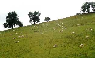
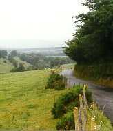
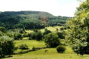
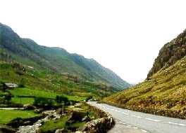
 The countryside of south central Wales
(left); typical fence- and stone wall-lined one- to one-and-a-half-lane
road going north thru the county of Powys (right)
The countryside of south central Wales
(left); typical fence- and stone wall-lined one- to one-and-a-half-lane
road going north thru the county of Powys (right)
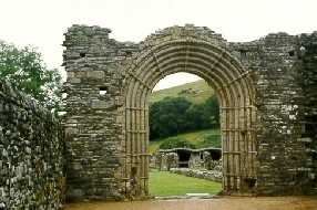
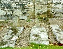
 Strata Florida (Ystrad Fflur - "Vale
of Flowers") Abbey - founded in 1164 by the Cistercians,
built 1184-1201; north of Tregaron, just southeast of Pontrhydfendigaid
(Bridge near the ford of the Blessed Virgin), and near the Teifi
Pools, headwaters of the River Teifi: door at the west end of
the nave (left); 12th c. graves (right)
Strata Florida (Ystrad Fflur - "Vale
of Flowers") Abbey - founded in 1164 by the Cistercians,
built 1184-1201; north of Tregaron, just southeast of Pontrhydfendigaid
(Bridge near the ford of the Blessed Virgin), and near the Teifi
Pools, headwaters of the River Teifi: door at the west end of
the nave (left); 12th c. graves (right)
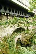
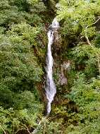
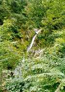
 Devil's Bridge - north of Strata Florida,
about 10 miles east and up the Rheidol River Valley (to an elevation
of almost 1000 ft) from the town of Aberystwyth (on the west central
coast): an iron bridge (1901), built over a stone bridge (1753),
which in turn is built over the ancient (12th c.) Pont-y-gwr-Drwg
(Bridge of the Evil One; left); it spans the chasm (The Vale of
Rheidol) at the lip of the 300 ft, multi-tiered Gyfarllwyd Falls
(center), at a bend of the Rheidol River where it is joined by
the Mynach, which plunges down into the chasm in a series of cataracts
called the Mynach Falls (right)
Devil's Bridge - north of Strata Florida,
about 10 miles east and up the Rheidol River Valley (to an elevation
of almost 1000 ft) from the town of Aberystwyth (on the west central
coast): an iron bridge (1901), built over a stone bridge (1753),
which in turn is built over the ancient (12th c.) Pont-y-gwr-Drwg
(Bridge of the Evil One; left); it spans the chasm (The Vale of
Rheidol) at the lip of the 300 ft, multi-tiered Gyfarllwyd Falls
(center), at a bend of the Rheidol River where it is joined by
the Mynach, which plunges down into the chasm in a series of cataracts
called the Mynach Falls (right)
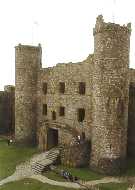
 Harlech (Bold Rock) Castle, on the
northwest coast above Barmouth, built by Edward I in 1283-9 on
a 200 ft crag above the Morfa Harlech marsh; it was the last Yorkist
stronghold in England and Wales to fall in the War of the Roses
(1455-85) - after a 7 year siege; and though a ruins by the 16th
c., the last Welsh fortress taken (in 1647) during the Civil War
Harlech (Bold Rock) Castle, on the
northwest coast above Barmouth, built by Edward I in 1283-9 on
a 200 ft crag above the Morfa Harlech marsh; it was the last Yorkist
stronghold in England and Wales to fall in the War of the Roses
(1455-85) - after a 7 year siege; and though a ruins by the 16th
c., the last Welsh fortress taken (in 1647) during the Civil War
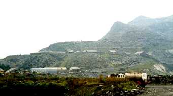
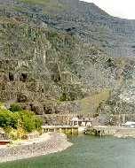
 The Gloddfa Ganol Slate Mine (left),
supposedly the world's largest, begun in 1818 and still in operation
today below the ravaged grey hills; Dolwyddelan Castle (ca. 1170),
an isolated square keep (right) on the ascent up the Lledr River
Valley to the Crimea Pass (1200+ ft) - birthplace of Llewelyn
the Great, captured and strengthened by Edward I in 1283, occupied
thru the 15th c.
The Gloddfa Ganol Slate Mine (left),
supposedly the world's largest, begun in 1818 and still in operation
today below the ravaged grey hills; Dolwyddelan Castle (ca. 1170),
an isolated square keep (right) on the ascent up the Lledr River
Valley to the Crimea Pass (1200+ ft) - birthplace of Llewelyn
the Great, captured and strengthened by Edward I in 1283, occupied
thru the 15th c.
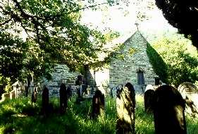
 Betwys-y-Coed (Buh-toos'-uh-coid';
Prayer House in the Forest), a holiday and summer tourist center
in the mountains of Snowdonia National Park, in northwest Wales:
the Old Church (14th c.), or Bede (left); Pont-y-Pair (Bridge
of the Cauldron; 1470), on the Llugwy River in the heart of town
(right)
Betwys-y-Coed (Buh-toos'-uh-coid';
Prayer House in the Forest), a holiday and summer tourist center
in the mountains of Snowdonia National Park, in northwest Wales:
the Old Church (14th c.), or Bede (left); Pont-y-Pair (Bridge
of the Cauldron; 1470), on the Llugwy River in the heart of town
(right)
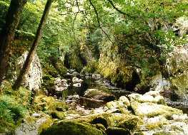
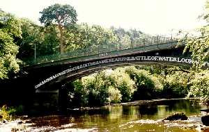
 Fairy Glen (left), a narrow wooded
gorge on the Conwy (above the confluence with the Llugwy) just
southeast of B-y-C. The Waterloo Bridge (right), an iron structure
built by Telford (in 1815, the year of the battle), spanning the
Conwy River in the southern part of town, below the confluence
with the Llugwy.
Fairy Glen (left), a narrow wooded
gorge on the Conwy (above the confluence with the Llugwy) just
southeast of B-y-C. The Waterloo Bridge (right), an iron structure
built by Telford (in 1815, the year of the battle), spanning the
Conwy River in the southern part of town, below the confluence
with the Llugwy.
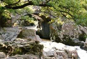
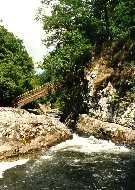
 The steeply angled Miners' Bridge,
over the Llugwy River just north of B-y-C (left), a favorite subject
of 19th century artists such as Turner and Cox; view of the Llugwy
River valley (right) from the Artists' Wood, on the slope above
the Miners' Bridge
The steeply angled Miners' Bridge,
over the Llugwy River just north of B-y-C (left), a favorite subject
of 19th century artists such as Turner and Cox; view of the Llugwy
River valley (right) from the Artists' Wood, on the slope above
the Miners' Bridge
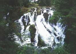
 Upper tier of Swallow Falls (left),
on the Llugwy River a few miles north of B-y-C. The Pass of Llanberis
(right), due west of B-y-C, a cleft which defines the northeast
flank of Snowdon, the highest mountain in England and Wales
Upper tier of Swallow Falls (left),
on the Llugwy River a few miles north of B-y-C. The Pass of Llanberis
(right), due west of B-y-C, a cleft which defines the northeast
flank of Snowdon, the highest mountain in England and Wales
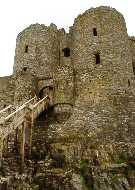
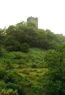
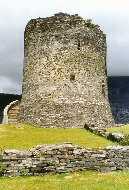
 Just outside Llanberis, the keep of
Dolbadarn Castle (left), built by Llewelyn the Great (early 13th
c.) on a ridge above Llyn (lake) Padarn, in turn viewed from the
top of the keep (center); tiers of the Dinorwig Slate Mine (right),
rising 1500 ft up the cliffs across Llyn Peris from the Castle
- now part of the National Grid's Dinorwig Pumped Storage Scheme,
with Peris (separated by a small isthmus, lower left, from Padarn)
acting as the lower reservoir and Marchlyn Mawr, 1600 ft above
in deep caverns excavated in the cliffs after quarrying ended
in 1969, as the upper reservoir
Just outside Llanberis, the keep of
Dolbadarn Castle (left), built by Llewelyn the Great (early 13th
c.) on a ridge above Llyn (lake) Padarn, in turn viewed from the
top of the keep (center); tiers of the Dinorwig Slate Mine (right),
rising 1500 ft up the cliffs across Llyn Peris from the Castle
- now part of the National Grid's Dinorwig Pumped Storage Scheme,
with Peris (separated by a small isthmus, lower left, from Padarn)
acting as the lower reservoir and Marchlyn Mawr, 1600 ft above
in deep caverns excavated in the cliffs after quarrying ended
in 1969, as the upper reservoir
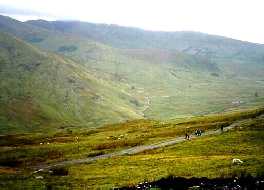
 Crossing the Llanberis Track (left),
complete with hikers, on an ascent of Snowdon (3560 ft; in Welsh,
"Yr Wyddfa Fawr") via the Snowdon Mountain Railway,
a single track narrow-gauge rack-and-pinion line, with views of
Moel Eilio and Y Foel Goch; Conwy Estuary, on the north central
Welsh coast (right)
Crossing the Llanberis Track (left),
complete with hikers, on an ascent of Snowdon (3560 ft; in Welsh,
"Yr Wyddfa Fawr") via the Snowdon Mountain Railway,
a single track narrow-gauge rack-and-pinion line, with views of
Moel Eilio and Y Foel Goch; Conwy Estuary, on the north central
Welsh coast (right)
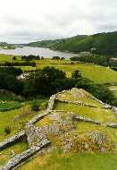
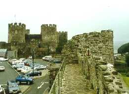
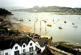 Conwy Castle (left), built (1283-7)
by James of St. George for Edward I, at the head of the Estuary
at the mouth of the River Gyffin; a close-up of the Town Walls
(right), over 1400 yards in circumference and 30 ft high, contemporary
and integral with the Castle - with 21 towers, three gates, and
a spur that runs out into the waters of the estuary to protect
the harbor, they surround the town
Conwy Castle (left), built (1283-7)
by James of St. George for Edward I, at the head of the Estuary
at the mouth of the River Gyffin; a close-up of the Town Walls
(right), over 1400 yards in circumference and 30 ft high, contemporary
and integral with the Castle - with 21 towers, three gates, and
a spur that runs out into the waters of the estuary to protect
the harbor, they surround the town
Interesting links:
Return to
Home Page