SAN ANTONIO
(Last updated 11/12/03)
The Spanish explorer de Vaca crossed a new river
in south Texas in 1535; local lore has it that the river finally
got its name - San Antonio - when a mass was said ca. 150 years
later (in 1691) at the 180-mile long river's headwaters on the
saint's day (June 13th) of Anthony of Padua. In 1718, Franciscans
led by Father Antonio Olivares founded the mission San Antonio
de Padua next to the presidio (fort) at a spring near the river's
headwaters. A few years later, both the presidio and the mission
were moved south to where the river bent sharply then doubled
back on itself - the Great Bend (GB) - so that homes could be
clustered along the waterway: the presidio, San Antonio de Bejar,
was relocated to the west of the GB (beside San Pedro Creek) on
what is now the Plaza de Armas; and after several intermediate
moves, the mission - consolidated with its neighbor and renamed
Mission San Antonio de Valera - was relocated to an area above
the east bank of the GB, now Alamo Plaza. By order of the King
of Spain, the Mission was secularized in 1793, became a military
outpost in 1803.
The Spaniards began damming, diverting,
and channeling the San Antonio River into "acequias"
as soon as they settled the area, a process periodically stimulated
by massive flooding (including a "flood of the century"
in 1819). In response to a drought that emptied the river in 1901
followed by a flood in 1902, and a repeat of this pattern over
the next 20 years - including 6 floods in 9 years, capped by another
flood of the century in 1921 that killed over 50 people, San Antonio's
citizens finally approved a multimillion dollar bond measure for
flood control in 1924. The project began with construction of
the Olmos Dam (completed in 1926) and a number of cutoff channels
that eliminated many of the smaller meandering bends of the river
and its feeder creeks.
During this same time period the City
Beautiful movement reached San Antonio, and citizens committees
(1909), together with a reform mayor who assumed office in 1912,
began to plant trees, rebuild bridges, and construct parks. These
two activities came together in 1929 when local architect Robert
Hugman presented a design for the preservation and development
of the Great Bend to the mayor and the San Antonio Conservation
Society at the same time work began on a major cutoff channel
to bypass the GB itself. The cutoff was completed on schedule,
but Hugman's plan for the GB was sidetracked until a special tax
levy and WPA funding (secured with the help of the WPA's district
engineer Edwin Arneson) finally led to a groundbreaking ceremony
for the GB river project in October of 1939. A completed River
Walk was formally turned over to the city by the WPA on March
13, 1941.
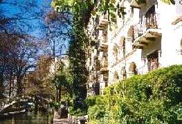
Views from the River Walk (Paseo
del Rio): The renovated (1968) and
enlarged (1979) 200-room hotel La Mansion
del Rio (left), built around the four-story, mansard-roofed stone
building of St. Mary's College (1852), is located near the northwest
corner of the GB; one of the signature arched bridges of native
limestone in the La Mansion area (right), designed to be high
enough for standing gondoliers to pass beneath
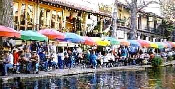
 At the center of the easternmost stretch
of the GB, Casa Rio (1946), the first restaurant on the River
Walk
At the center of the easternmost stretch
of the GB, Casa Rio (1946), the first restaurant on the River
Walk
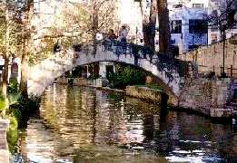
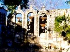
 The river literally runs through the
open-air Arneson River Theater (1941), located just past the southeast
corner of the GB; grass-covered bleacher steps, with seating for
over 1000, occupy the south bank while the stage, with its backdrop
of three stone arches and bells (dedicated to architect Hugman
in 1978), is located on the north - the two are connected by Rosita's
Bridge
The river literally runs through the
open-air Arneson River Theater (1941), located just past the southeast
corner of the GB; grass-covered bleacher steps, with seating for
over 1000, occupy the south bank while the stage, with its backdrop
of three stone arches and bells (dedicated to architect Hugman
in 1978), is located on the north - the two are connected by Rosita's
Bridge
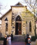
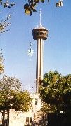
 The refurbished (1939) neighborhood
of La Villita, the original (1809) settlement of "Old San
Antonio" (located on the south bank just above the Theater's
bleacher seating), contains the Little Church (1879; left), a
favorite place for weddings. La Villita also provides a good vantage
point to view the Tower of the Americas (right), the theme structure
for HemisFair '68, complete with glass-walled elevators and revolving
restaurant above the 500-ft level, an observation deck at the
600-ft level, and a massive antenna that brings its total height
to 750 ft
The refurbished (1939) neighborhood
of La Villita, the original (1809) settlement of "Old San
Antonio" (located on the south bank just above the Theater's
bleacher seating), contains the Little Church (1879; left), a
favorite place for weddings. La Villita also provides a good vantage
point to view the Tower of the Americas (right), the theme structure
for HemisFair '68, complete with glass-walled elevators and revolving
restaurant above the 500-ft level, an observation deck at the
600-ft level, and a massive antenna that brings its total height
to 750 ft
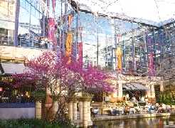
 Several significant flood control and
beautification projects have been completed on the River Walk
since 1941: a river extension leading to a new Convention Center
in 1968 to coincide with the city's World's Fair; the Paseo del
Alamo project in 1979 linking the River Walk to the Alamo; and
an extension (of the '68 extension) leading to the Rivercenter.
The extension leads eastward to the Convention Center and to the
lagoon of the Rivercenter Mall (1988), home to over 130 stores
and restaurants and a new focal point for river activities
Several significant flood control and
beautification projects have been completed on the River Walk
since 1941: a river extension leading to a new Convention Center
in 1968 to coincide with the city's World's Fair; the Paseo del
Alamo project in 1979 linking the River Walk to the Alamo; and
an extension (of the '68 extension) leading to the Rivercenter.
The extension leads eastward to the Convention Center and to the
lagoon of the Rivercenter Mall (1988), home to over 130 stores
and restaurants and a new focal point for river activities
 Return to Home Page