NEW ORLEANS-2
(Last updated 3/15/03)
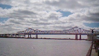
Canal Street, historically NO's main
thoroughfare, separates the French Quarter from the Central Business
District, which is bounded by Canal and the elevated Pontchartrain
Expressway north to south, the river and Claiborne Avenue east
to west. The Expressway leads to the distinctive cantilever truss
twin highway spans of the Greater New Orleans Bridge (also known
as the Crescent City Connection), which provides a major highway
link for travellers and NO residents alike across the Mississippi
River; the original 2-lane #1, with a channel span of 1575 ft
and a total length of 2.3 miles, was completed in 1958, widened
to 4 lanes in 1993; the 4-lane span of #2, which parallels #1
ca 400 ft to the north, is 1595 ft long
 The northern section of the CBD, originally
a part of Bienville's estate, became the Faubourg Ste. Marie when
Bernard Gravier decided to subdivide it after the death of his
wife, a name it retained throughout its 19th century settlement
by the wave of American immigrants who arrived in NO after 1803;
Gravier's actions also initiated the trend of subdividing successive
plantations upriver from the Vieux Carre into residential suburbs.
New construction in the area was spurred by completion of the
Superdome (1967-75) at its northern end, and it is now mostly
commercial in character.
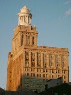
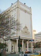
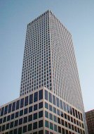
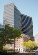
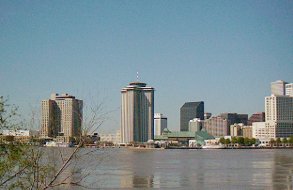
On the other hand, mainly because of
the 1984 NO World's Fair (which, while financially unsuccessful,
provided the impetus for its revitalization), the previously derelict
southern section of the CBD - known to locals as the Warehouse
District - has become a thriving blend of residential apartments
and condos, restaurants, art galleries, office buildings, and
hotels. These include the 355-ft, 20-story Hibernia Bank Building
(1921; left), tallest in NO until 1965; Le Pavillon (1970; left
center), a restoration of NO's grand Denechaud Hotel (1907; on
the site previously occupied by the main depot of the NO&C
RR in the 1840s); the 697-ft, 51-story One Shell Square (1972;
right center), tallest building in NO; and the massive 28-floor
Poydras Center (1983; right), looming over the Whitney Bank-Poydras
Branch (1890), recently reincarnated as the Whitney-Wyndham Hotel
(2000)
The northern section of the CBD, originally
a part of Bienville's estate, became the Faubourg Ste. Marie when
Bernard Gravier decided to subdivide it after the death of his
wife, a name it retained throughout its 19th century settlement
by the wave of American immigrants who arrived in NO after 1803;
Gravier's actions also initiated the trend of subdividing successive
plantations upriver from the Vieux Carre into residential suburbs.
New construction in the area was spurred by completion of the
Superdome (1967-75) at its northern end, and it is now mostly
commercial in character.
On the other hand, mainly because of
the 1984 NO World's Fair (which, while financially unsuccessful,
provided the impetus for its revitalization), the previously derelict
southern section of the CBD - known to locals as the Warehouse
District - has become a thriving blend of residential apartments
and condos, restaurants, art galleries, office buildings, and
hotels. These include the 355-ft, 20-story Hibernia Bank Building
(1921; left), tallest in NO until 1965; Le Pavillon (1970; left
center), a restoration of NO's grand Denechaud Hotel (1907; on
the site previously occupied by the main depot of the NO&C
RR in the 1840s); the 697-ft, 51-story One Shell Square (1972;
right center), tallest building in NO; and the massive 28-floor
Poydras Center (1983; right), looming over the Whitney Bank-Poydras
Branch (1890), recently reincarnated as the Whitney-Wyndham Hotel
(2000)
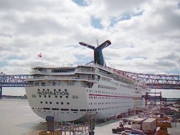
 A tourist friendly riverfront now runs
north (downriver, in NOese) from the Expressway across the CBD
and FQ to Esplanade Avenue, a radical change from the situation
less than 30 years ago when there was almost no riverfront access
at all. The upriver end of the CBD is anchored by the huge Morial
Convention Center (1985; third largest in the country), which
attracts more than a million convention-goers annually; the MCC
traces its origins directly to the Fair. The Julia Street Wharf
sits below the MCC at river level; the 855-ft, 2000-passenger
Carnival superliner Inspiration (left) departs regularly from
JSW's passenger terminal for week-long cruises to the Caribbean.
The next portion of the CBD's waterfront, another site from the
Fair, contains the Riverwalk Marketplace (right)
A tourist friendly riverfront now runs
north (downriver, in NOese) from the Expressway across the CBD
and FQ to Esplanade Avenue, a radical change from the situation
less than 30 years ago when there was almost no riverfront access
at all. The upriver end of the CBD is anchored by the huge Morial
Convention Center (1985; third largest in the country), which
attracts more than a million convention-goers annually; the MCC
traces its origins directly to the Fair. The Julia Street Wharf
sits below the MCC at river level; the 855-ft, 2000-passenger
Carnival superliner Inspiration (left) departs regularly from
JSW's passenger terminal for week-long cruises to the Caribbean.
The next portion of the CBD's waterfront, another site from the
Fair, contains the Riverwalk Marketplace (right)
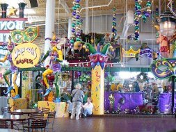
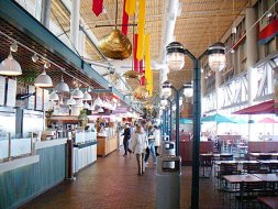
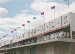 Opened in 1986, the RM, a 1/2-mile
long, multi-level structure, now contains over 140 unique shops
(left), restaurants (right), and trendy pushcarts that attract
over 70% of the 10 million tourists who visit NO each year. The
RM (as well as the Julia Street Wharf and the Hilton) suffered
significant damage when it was hit head-on by the fully laden
735-ft freighter Bright Field in December of 1996, but a refurbished
RM was quickly reopened (in stages) and was fully rebuilt by the
3rd Q of 1997
Opened in 1986, the RM, a 1/2-mile
long, multi-level structure, now contains over 140 unique shops
(left), restaurants (right), and trendy pushcarts that attract
over 70% of the 10 million tourists who visit NO each year. The
RM (as well as the Julia Street Wharf and the Hilton) suffered
significant damage when it was hit head-on by the fully laden
735-ft freighter Bright Field in December of 1996, but a refurbished
RM was quickly reopened (in stages) and was fully rebuilt by the
3rd Q of 1997
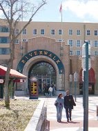
 An upper-story exit on the downriver
end of the Riverwalk (left) leads directly onto the pedestrian-friendly,
multi-level Plaza de Espana (Spanish Plaza; right) at the foot
of Canal Street in front of the World Trade Center, in an area
formerly called Eads Plaza (after the engineer whose 1870 design
for a jetty prevented silting at the mouth of the Mississippi
and saved the Port of NO); in part a gift from the Spanish government,
it was dedicated in 1978. The Plaza ends at the Canal Street Ferry
Embarcation Building
An upper-story exit on the downriver
end of the Riverwalk (left) leads directly onto the pedestrian-friendly,
multi-level Plaza de Espana (Spanish Plaza; right) at the foot
of Canal Street in front of the World Trade Center, in an area
formerly called Eads Plaza (after the engineer whose 1870 design
for a jetty prevented silting at the mouth of the Mississippi
and saved the Port of NO); in part a gift from the Spanish government,
it was dedicated in 1978. The Plaza ends at the Canal Street Ferry
Embarcation Building
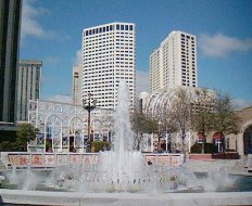
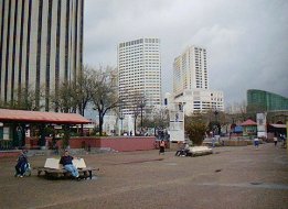 The Plaza has food carts, benches,
and a ticket booth for the riverboat Cajun Queen, which docks
at its seawall (left), but its focus is its Fountain, surrounded
by decorated tilework illustrating the Coats of Arms of the Spanish
provinces (center). The FQ's waterfront beyond starts with the
Canal Street Dock, which holds the Audubon Institute's million-gallon
Aquarium of the Americas (behind the Embarcation Building; right),
then continues as the Woldenberg Waterfront Park and the Moon
Walk
The Plaza has food carts, benches,
and a ticket booth for the riverboat Cajun Queen, which docks
at its seawall (left), but its focus is its Fountain, surrounded
by decorated tilework illustrating the Coats of Arms of the Spanish
provinces (center). The FQ's waterfront beyond starts with the
Canal Street Dock, which holds the Audubon Institute's million-gallon
Aquarium of the Americas (behind the Embarcation Building; right),
then continues as the Woldenberg Waterfront Park and the Moon
Walk

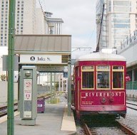
 In the early '80s, the city decided
to construct a new single track streetcar line along the riverfront
to aid weary sightseers; in 1988, the 1.5 mi, 10-stop Riverfront
line, which runs from the FQ's Esplanade Avenue/Old Mint and French
Market to the CBD's Thalia Street/Convention Center, became operational.
For use on the line, the city recovered and restored three PT
cars, now called the "Red Ladies," that had been "surplused"
when the Canal Street line was discontinued in 1964 (the "Desire"
line was replaced by buses in 1948, just a year after it was immortalized
by Tennessee Williams). Immediately popular, the Riverfront line
was expanded to two tracks in 1990, and other types of cars were
added to provide additional capacity; plans are already underway
to extend the line in both directions
In the early '80s, the city decided
to construct a new single track streetcar line along the riverfront
to aid weary sightseers; in 1988, the 1.5 mi, 10-stop Riverfront
line, which runs from the FQ's Esplanade Avenue/Old Mint and French
Market to the CBD's Thalia Street/Convention Center, became operational.
For use on the line, the city recovered and restored three PT
cars, now called the "Red Ladies," that had been "surplused"
when the Canal Street line was discontinued in 1964 (the "Desire"
line was replaced by buses in 1948, just a year after it was immortalized
by Tennessee Williams). Immediately popular, the Riverfront line
was expanded to two tracks in 1990, and other types of cars were
added to provide additional capacity; plans are already underway
to extend the line in both directions
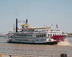
 The 190-ft, 1000-passenger Creole Queen
(1983; left), powered by a 24-ft diameter paddlewheel, provides
a great overview of the city and surrounding environs on its 2-hr
cruises. A 6-minute free ride (for pedestrians) on the Canal Street
Ferry, which has been in continuous operation in one form or another
between the foot of Canal Street and Algiers Point since 1828,
provides another; a view from the ferry's top deck (right) shows
a third option for River exploration, the 265-ft, 1600-passenger,
steam-powered Natchez IX (1975; patterned after an old Ohio River
sternwheeler packet), berthed at the recently upgraded Toulouse
Street Wharf near the end of Woldenberg Riverfront Park, with
the steeple of the St Louis Cathedral and the renovated Jax Brewery
(now a shopping center) on its left, the promenade of the Moon
Walk (after ex-Mayor Moon Landrieu; on the levee behind Artillery
Park) on its right
The 190-ft, 1000-passenger Creole Queen
(1983; left), powered by a 24-ft diameter paddlewheel, provides
a great overview of the city and surrounding environs on its 2-hr
cruises. A 6-minute free ride (for pedestrians) on the Canal Street
Ferry, which has been in continuous operation in one form or another
between the foot of Canal Street and Algiers Point since 1828,
provides another; a view from the ferry's top deck (right) shows
a third option for River exploration, the 265-ft, 1600-passenger,
steam-powered Natchez IX (1975; patterned after an old Ohio River
sternwheeler packet), berthed at the recently upgraded Toulouse
Street Wharf near the end of Woldenberg Riverfront Park, with
the steeple of the St Louis Cathedral and the renovated Jax Brewery
(now a shopping center) on its left, the promenade of the Moon
Walk (after ex-Mayor Moon Landrieu; on the levee behind Artillery
Park) on its right
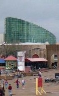
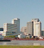
 View of the NO waterfront from the
Old Algiers Wharf (left) - starting at far left, the partially
hidden low, white rectangular form of the Convention Center; the
29-story Hilton Riverside Hotel (1972), with the Creole Queen
docked in front of it; the 33-story World Trade Center (1965;
tallest building in NO until 1969; topped by a rotating restaurant)
with the 22-story Lykes Center (1973) behind it; the turreted,
low green roof of the block-long Harrah's Casino, with the black
granite, 32-floor Texaco Center behind it; the John James Audubon
Riverboat (named for the famous ornithologist, a brief resident
of NO in the 1820s, the JJA provides 1-hr cruises between the
Aquarium and the Audubon Zoo, located upriver in Audubon Park)
docked in front of the Aquarium, with the reddish, step-roofed,
39-floor Energy Center (1984) behind it; and at far right, the
two-tiered 27-floor Wydham Hotel at Canal Place, with the 28-floor
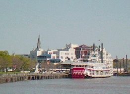
Entergy Tower (1983) in the background. Another view (partially
obscured by the back of a tug and a string of red barges) from
the levee around the Point (right) - from far left, the Wydham
Hotel and Entergy Tower; the square, white, peaked-roof Jax Brewery;
and the square shapes of the Riverside Market and the Red Stores
(a 19th century market, rebuilt in 1933), with the 47-floor Sheraton
(1985), 42-floor Marriott (1972), and 645-ft, 53-floor Place St
Charles (1985) behind them
View of the NO waterfront from the
Old Algiers Wharf (left) - starting at far left, the partially
hidden low, white rectangular form of the Convention Center; the
29-story Hilton Riverside Hotel (1972), with the Creole Queen
docked in front of it; the 33-story World Trade Center (1965;
tallest building in NO until 1969; topped by a rotating restaurant)
with the 22-story Lykes Center (1973) behind it; the turreted,
low green roof of the block-long Harrah's Casino, with the black
granite, 32-floor Texaco Center behind it; the John James Audubon
Riverboat (named for the famous ornithologist, a brief resident
of NO in the 1820s, the JJA provides 1-hr cruises between the
Aquarium and the Audubon Zoo, located upriver in Audubon Park)
docked in front of the Aquarium, with the reddish, step-roofed,
39-floor Energy Center (1984) behind it; and at far right, the
two-tiered 27-floor Wydham Hotel at Canal Place, with the 28-floor
Entergy Tower (1983) in the background. Another view (partially
obscured by the back of a tug and a string of red barges) from
the levee around the Point (right) - from far left, the Wydham
Hotel and Entergy Tower; the square, white, peaked-roof Jax Brewery;
and the square shapes of the Riverside Market and the Red Stores
(a 19th century market, rebuilt in 1933), with the 47-floor Sheraton
(1985), 42-floor Marriott (1972), and 645-ft, 53-floor Place St
Charles (1985) behind them
 A short ride uptown past the CBD on
the St Charles streetcar leads to the (Upper) Garden District,
a square area bounded by Jackson and Louisiana Avenues, and Magazine
and St. Charles Streets. Once the separate town of Lafayette (the
Livaudais Plantation, subdivided in 1825, combined with two other
Faubourgs in 1832; annexed to NO in 1852), the GD became a magnet
for newly affluent Americans who had struck it rich in NO but
were made to feel unwelcome in the FQ by the latter's Creole inhabitants.
In contrast to the Creole houses of the FQ with their interior
courtyards, the Americans took advantage of the larger lots of
the GD to build huge mansions surrounded by gardens and lawns.
Today the entire GD is on the National Register of Historic Places,
offering the visitor the opportunity to view an incredible collection
of Antebellum, Greek Revival, Italianate, and Victorian architecture
within a few square blocks.
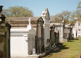
Lafayette Cemetery #1 (1833; left),
on Washington Avenue in the center of the GD, is one of the oldest
in NO; examples of classical above-ground and multiple-burial
techniques, as well as many literary sites such as Ann Rice's
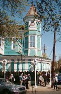
Mayfair witches tomb, are located here. Across the street, the
turreted Victorian mansion of Commander's Palace (right) has been
a restaurant since it was built by Emile C in 1880 - although
it also housed a speakeasy and bordello in the 1920's; the Brennan
family took over its operation in 1974, and with the help of executive
chefs Paul Prudhomme (1974-82) and Emeril Lagasse (1982-90), turned
it into one of the best, and best-known, restaurants in the country
A short ride uptown past the CBD on
the St Charles streetcar leads to the (Upper) Garden District,
a square area bounded by Jackson and Louisiana Avenues, and Magazine
and St. Charles Streets. Once the separate town of Lafayette (the
Livaudais Plantation, subdivided in 1825, combined with two other
Faubourgs in 1832; annexed to NO in 1852), the GD became a magnet
for newly affluent Americans who had struck it rich in NO but
were made to feel unwelcome in the FQ by the latter's Creole inhabitants.
In contrast to the Creole houses of the FQ with their interior
courtyards, the Americans took advantage of the larger lots of
the GD to build huge mansions surrounded by gardens and lawns.
Today the entire GD is on the National Register of Historic Places,
offering the visitor the opportunity to view an incredible collection
of Antebellum, Greek Revival, Italianate, and Victorian architecture
within a few square blocks.
Lafayette Cemetery #1 (1833; left),
on Washington Avenue in the center of the GD, is one of the oldest
in NO; examples of classical above-ground and multiple-burial
techniques, as well as many literary sites such as Ann Rice's
Mayfair witches tomb, are located here. Across the street, the
turreted Victorian mansion of Commander's Palace (right) has been
a restaurant since it was built by Emile C in 1880 - although
it also housed a speakeasy and bordello in the 1920's; the Brennan
family took over its operation in 1974, and with the help of executive
chefs Paul Prudhomme (1974-82) and Emeril Lagasse (1982-90), turned
it into one of the best, and best-known, restaurants in the country
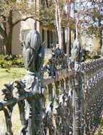
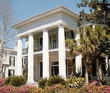
 The Short (-Favrot/Moran) House (1859;
left), in the 1400 block of Fourth Street, an 8000 sq-ft Italianate
Villa with Greek Revival interior, was designed by local architect
Henry Howard for "Colonel" Robert Short, an importer;
its Cornstalk Fence (right) was cast by the Philadelphia foundry
of Wood & Perot
The Short (-Favrot/Moran) House (1859;
left), in the 1400 block of Fourth Street, an 8000 sq-ft Italianate
Villa with Greek Revival interior, was designed by local architect
Henry Howard for "Colonel" Robert Short, an importer;
its Cornstalk Fence (right) was cast by the Philadelphia foundry
of Wood & Perot
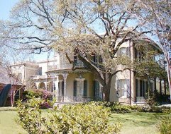
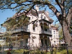
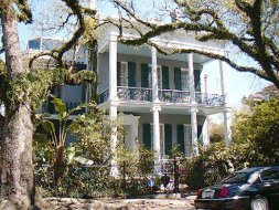
 The Thomas N Bernard House (ca 1861;
left), in the 1300 block of Harmony, is a "simple" Louisiana
raised cottage supported on brick piers; the Bradish Johnson House
(1872; center), in the 2300 block of Prytania, by James Freret
in the Second Empire-style, became the Louise S McGehee School
for Girls in 1929; the Corinthian columns on the portico (right)
of a huge house nearby reflect an extreme of the Greek Revival
style
The Thomas N Bernard House (ca 1861;
left), in the 1300 block of Harmony, is a "simple" Louisiana
raised cottage supported on brick piers; the Bradish Johnson House
(1872; center), in the 2300 block of Prytania, by James Freret
in the Second Empire-style, became the Louise S McGehee School
for Girls in 1929; the Corinthian columns on the portico (right)
of a huge house nearby reflect an extreme of the Greek Revival
style
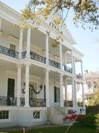
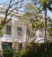
 The Toby-Westfeldt House (c. 1838 -
extensive changes made in 1855), also in the 2300 block of Prytania,
a simple West Indies plantation-style house, is believed to be
the earliest in the GD; the Carroll-Crawford House (1869; center),
on the 1300 block of First Street, is a massive Italianate mansion
(by Samuel Jamison), yet its portico (right) shows deft touches
and delicate detail
The Toby-Westfeldt House (c. 1838 -
extensive changes made in 1855), also in the 2300 block of Prytania,
a simple West Indies plantation-style house, is believed to be
the earliest in the GD; the Carroll-Crawford House (1869; center),
on the 1300 block of First Street, is a massive Italianate mansion
(by Samuel Jamison), yet its portico (right) shows deft touches
and delicate detail
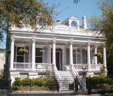
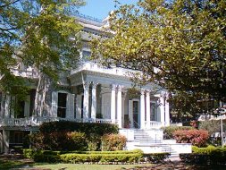
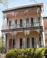 The Brevard (-Mahat/Wisdom) House (1857;
left), across the street from the C-C on First, is a Greek Revival
town house that served as the setting for the "Witching Hour"
novels by Anne Rice - who lives there! The Morris-Israel House
(1869; right), constructed by builder-architect Jamison at the
same time he was building the C-C house down the block
The Brevard (-Mahat/Wisdom) House (1857;
left), across the street from the C-C on First, is a Greek Revival
town house that served as the setting for the "Witching Hour"
novels by Anne Rice - who lives there! The Morris-Israel House
(1869; right), constructed by builder-architect Jamison at the
same time he was building the C-C house down the block
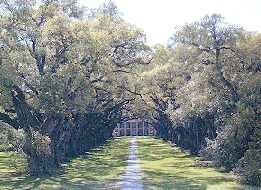
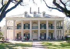
 A few miles outside the city, a sampling
of the many sugar plantations that flourished upriver from NO
along the Mississippi River before the Civil War: planted by an
unknown French settler over 100 years before the house was built,
a dramatic arch of 28 live oak trees (left) lines the entranceway
to the Greek Revival style Oak Alley Plantation, built for Jaques
Telesphore Roman in 1837-9 (right)
A few miles outside the city, a sampling
of the many sugar plantations that flourished upriver from NO
along the Mississippi River before the Civil War: planted by an
unknown French settler over 100 years before the house was built,
a dramatic arch of 28 live oak trees (left) lines the entranceway
to the Greek Revival style Oak Alley Plantation, built for Jaques
Telesphore Roman in 1837-9 (right)
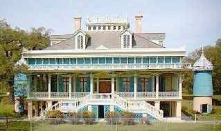
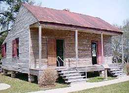
 The Creole style house of San Francisco
Plantation (left), built in 1856 for Edmond Bozonier Marmillion,
is flanked by two huge cisterns which provided running water -
the name is a corruption of St. Frusquin, derived from the French
slang "sans fruscins," without a penny; slave quarters
on the grounds (right) date from 1830
The Creole style house of San Francisco
Plantation (left), built in 1856 for Edmond Bozonier Marmillion,
is flanked by two huge cisterns which provided running water -
the name is a corruption of St. Frusquin, derived from the French
slang "sans fruscins," without a penny; slave quarters
on the grounds (right) date from 1830
 Go to New Orleans-1
| Return to Home Page
Go to New Orleans-1
| Return to Home Page