ATLANTA-2/North Georgia
Area
(Last updated 11/25/00)
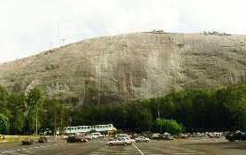
Stone Mountain Park, about 16 miles
east of Atlanta: the "stone" is the largest piece of
exposed granite in the world, 825 feet high and covering 583 acres
(left) - home to first the Creek, then the Cherokee, "discovered"
by the Spaniard Juan Pardo in 1567, and privately owned until
purchased by the state in 1958, the site was used as a rock quarry
to supply materials for projects and locations as diverse as the
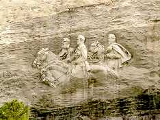
locks of the Panama Canal and the U.S. Capitol Building. The Confederate
Memorial Carving of Davis, Lee, and Jackson - begun in 1916 by
Borglum of Mt. Rushmore fame, but actually carved between 1964-72
using thermo-jet torch technology - towers 400 feet above the
ground and covers nearly 3 acres on the north face, making it
the largest bas-relief sculpture in the world (right)
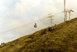
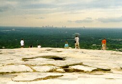
 The Mountaintop Skylift, which climbs
the northeast side, was added in 1996 for the Olympic games (left);
the reward for braving the 1.3 mile trail to the top - a view
of the skyline of Atlanta in the distance (right)
The Mountaintop Skylift, which climbs
the northeast side, was added in 1996 for the Olympic games (left);
the reward for braving the 1.3 mile trail to the top - a view
of the skyline of Atlanta in the distance (right)
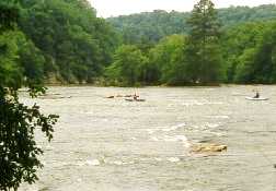
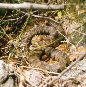
 The Palisades Unit of the Chatahoochee
River National Recreation Area, in the northern suburbs of Atlanta
- kayakers enjoy the cool waters on a hot day (left); other sights
along the Chatahoochee - a timber rattlesnake (right)
The Palisades Unit of the Chatahoochee
River National Recreation Area, in the northern suburbs of Atlanta
- kayakers enjoy the cool waters on a hot day (left); other sights
along the Chatahoochee - a timber rattlesnake (right)
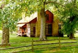
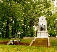
 Kennesaw Mountain National Battlefield
Park, about 15 miles northwest of Atlanta and just west of the
city of Marietta. The farmhouse built by Peter Kolb in 1836 (left),
site of the Battle of Kolb's Farm, which forced Sherman to stop
and attack the Confederate Army entrenched on the mountains. The
Illinois Monument at Cheatham Hill (right), completed in 1914
to commemorate the 500 dead from that state in the Battle - the
Union attackers were stopped in this area, called "Dead Angle";
some Illinois men remained behind, 20 yards from the Rebel line,
trying to dig a tunnel - left of the sign - to blow a hole in
the Confederate entrenchments
Kennesaw Mountain National Battlefield
Park, about 15 miles northwest of Atlanta and just west of the
city of Marietta. The farmhouse built by Peter Kolb in 1836 (left),
site of the Battle of Kolb's Farm, which forced Sherman to stop
and attack the Confederate Army entrenched on the mountains. The
Illinois Monument at Cheatham Hill (right), completed in 1914
to commemorate the 500 dead from that state in the Battle - the
Union attackers were stopped in this area, called "Dead Angle";
some Illinois men remained behind, 20 yards from the Rebel line,
trying to dig a tunnel - left of the sign - to blow a hole in
the Confederate entrenchments
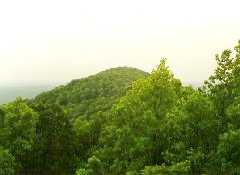
 Looking south from the 1000 ft. summit
of Kennesaw Mountain to Little Kennesaw; the major Union attack
occured at Pigeon Hill, across a gorge to the south; the Confederates
held there, finally forcing the Union troops to withdraw
Looking south from the 1000 ft. summit
of Kennesaw Mountain to Little Kennesaw; the major Union attack
occured at Pigeon Hill, across a gorge to the south; the Confederates
held there, finally forcing the Union troops to withdraw
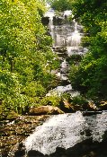
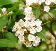
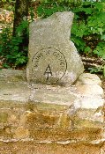
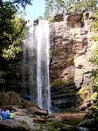
 Amicolola (Cherokee for "tumbling
waters") Falls State Park, about an hour north of Atlanta:
the upper part of its 729-ft cascade-type falls (left); the Mountain
Laurel (center), Kalmia latifolia, the "other rhododendron,"
grows an profusion along the Base of the Falls Trail; a marker
at the start of the 8 mile Southern Terminus Access Trail leading
north from the Park to Springer Mountain and the "official"
southern end of the 2,150 mile Appalachian Trail (right)
Amicolola (Cherokee for "tumbling
waters") Falls State Park, about an hour north of Atlanta:
the upper part of its 729-ft cascade-type falls (left); the Mountain
Laurel (center), Kalmia latifolia, the "other rhododendron,"
grows an profusion along the Base of the Falls Trail; a marker
at the start of the 8 mile Southern Terminus Access Trail leading
north from the Park to Springer Mountain and the "official"
southern end of the 2,150 mile Appalachian Trail (right)
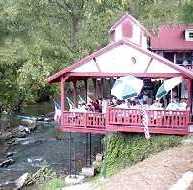
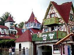
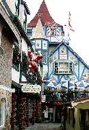
 Located in the high mountain watershed
of the Chattahoochee River, which winds through the center of
town (left), Helen - about an hour and a half from Atlanta in
the northeast corner of the state, has become the third most popular
destination in Georgia since its reincarnation in 1970 as a Bavarian
Village (right)
Located in the high mountain watershed
of the Chattahoochee River, which winds through the center of
town (left), Helen - about an hour and a half from Atlanta in
the northeast corner of the state, has become the third most popular
destination in Georgia since its reincarnation in 1970 as a Bavarian
Village (right)
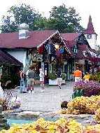
 Helen's Oktoberfest attracts hundreds
of thousands of visitors during its 6 week run, and is probably
the only Oktoberfest in the world where the crowds react more
strongly to the strains of Dixie than to the Chicken Dance
Helen's Oktoberfest attracts hundreds
of thousands of visitors during its 6 week run, and is probably
the only Oktoberfest in the world where the crowds react more
strongly to the strains of Dixie than to the Chicken Dance
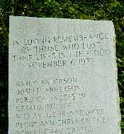
 East of Helen near the South Carolina
border, 186-ft Toccoa Falls (left) is located on the campus of
the Toccoa Falls Bible College (1907); a large stone tablet nearby
(right) lists the names of the 39 people who lost their lives
in 1977 when the dam on the plateau above broke and the waters
of its reservoir devastated the canyon below
East of Helen near the South Carolina
border, 186-ft Toccoa Falls (left) is located on the campus of
the Toccoa Falls Bible College (1907); a large stone tablet nearby
(right) lists the names of the 39 people who lost their lives
in 1977 when the dam on the plateau above broke and the waters
of its reservoir devastated the canyon below
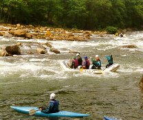
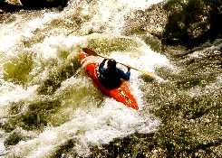
 About 2 hours due north of Atlanta
in southeast Tennessee, a 4.5 mi. stretch of class III/IV whitewater
on the Ocoee River below the TVA's Diversion Dam #2 is one of
the premier playboating rivers in the US - by an act of Congress,
water is released for recreation purposes 116 days per year on
a fixed schedule from April to late October; just downstream of
the put-in pole, rafters line up at Grumpy (left) and head for
White Face Rock; further downstream, a kayaker (center) lines
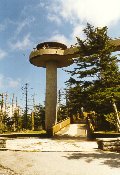
up to enter a surfing hole below the #2 Powerhouse. About 2 hours
northeast of Atlanta (through North Carolina along the Nantahala
River Valley, then north at Cherokee and across the border into
the Great Smoky Mountains), the Observation Tower at the top of
Clingman's Dome (right) is the highest point (6,642 ft.) in Tennessee
and one of the highest on the East Coast
About 2 hours due north of Atlanta
in southeast Tennessee, a 4.5 mi. stretch of class III/IV whitewater
on the Ocoee River below the TVA's Diversion Dam #2 is one of
the premier playboating rivers in the US - by an act of Congress,
water is released for recreation purposes 116 days per year on
a fixed schedule from April to late October; just downstream of
the put-in pole, rafters line up at Grumpy (left) and head for
White Face Rock; further downstream, a kayaker (center) lines
up to enter a surfing hole below the #2 Powerhouse. About 2 hours
northeast of Atlanta (through North Carolina along the Nantahala
River Valley, then north at Cherokee and across the border into
the Great Smoky Mountains), the Observation Tower at the top of
Clingman's Dome (right) is the highest point (6,642 ft.) in Tennessee
and one of the highest on the East Coast
 Go to Atlanta-1 | Return
to Home Page
Go to Atlanta-1 | Return
to Home Page