The
GORGE-1
(Last updated 2/8/08)
To most Portlanders, "the Gorge" means
the stretch of Columbia River from Crown Point to Hood River -
the narrowest part of the river's canyon, with rock walls that
routinely soar over 3000 ft high; but in 1986 Congress declared
a longer stretch - beginning about 17 miles east of Portland and
extending upriver for another 55 miles to The Dalles - as the
Columbia River Gorge National Scenic Area.
The Gorge is a spectacular river canyon
cut through the Cascade Mountain Range and its underlying lava
plateau, and is both geologically and scenically unique. The rocks
along this section of the largest river in the west (carrying
over a third the volume of the Mississippi) are almost all dark
basalts, and reveal the many volcanic eruptions and giant landslides
that, over the eons, have intermittently blocked the flow of the
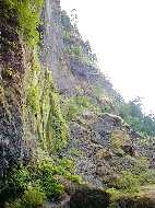
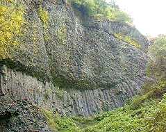
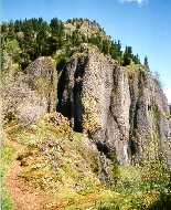
river. The typical lichen-covered cliffs illustrate all of the
various types of basalts, including rubbly "aa" (left)
and pillowy "pahoehoe" above an arc of columnar basalt
(right)
 The Gorge area is accessible periodically
from Interstate 84, the main highway east from Portland - a water-level
route constructed in the early '50s, largely on fill material
dredged from the Columbia. But a still-usable 22-mile section
of the Historic Columbia River Highway (1913-22; designed and
built by Samuel Lancaster, an engineer and landscape architect;
designated as a National Historic Landmark in 2000) - the first
scenic highway in the nation, and considered a technological marvel
when it opened in 1915 (even though it wasn't initially paved)
- provides a more leisurely pace along its narrow, curving roadway,
and offers access to almost all of the attractions of the western
Gorge, including dozens of Waterfalls
and over 200 miles of hiking trails, most within an hour of downtown
Portland.
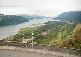
Heading east from Portland on the HCRH,
the first good overview of the Gorge is provided from a mini-park
just past Corbett called "The Women's Forum" on Chanticleer
Point (named for the hotel once located there) - looking east
past the 733-ft high rocky promentory of Crown Point, remnant
of a 25 million year old flood basalt flow
The Gorge area is accessible periodically
from Interstate 84, the main highway east from Portland - a water-level
route constructed in the early '50s, largely on fill material
dredged from the Columbia. But a still-usable 22-mile section
of the Historic Columbia River Highway (1913-22; designed and
built by Samuel Lancaster, an engineer and landscape architect;
designated as a National Historic Landmark in 2000) - the first
scenic highway in the nation, and considered a technological marvel
when it opened in 1915 (even though it wasn't initially paved)
- provides a more leisurely pace along its narrow, curving roadway,
and offers access to almost all of the attractions of the western
Gorge, including dozens of Waterfalls
and over 200 miles of hiking trails, most within an hour of downtown
Portland.
Heading east from Portland on the HCRH,
the first good overview of the Gorge is provided from a mini-park
just past Corbett called "The Women's Forum" on Chanticleer
Point (named for the hotel once located there) - looking east
past the 733-ft high rocky promentory of Crown Point, remnant
of a 25 million year old flood basalt flow
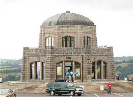
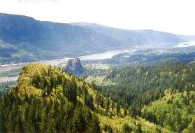
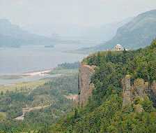 Crown Point is topped by Vista House
(left), which was completed in 1918 as a memorial to Oregon's
pioneers, and as a comfort station for travelers on the HCRH.
Looking east into the Gorge from Crown Point (right), the diagonal
stripe of I-84 parallels the River on the right, with Beacon
Rock framed by the canyon in the distance
Crown Point is topped by Vista House
(left), which was completed in 1918 as a memorial to Oregon's
pioneers, and as a comfort station for travelers on the HCRH.
Looking east into the Gorge from Crown Point (right), the diagonal
stripe of I-84 parallels the River on the right, with Beacon
Rock framed by the canyon in the distance
 The west end of the Gorge is very wet,
with rainfall approaching 100 inches annually; this moisture supports
a dense forest cover consisting of lichen- and moss-covered fir,
maple, and alder, with a thick understory of ferns. Around a bend
of the canyon just before Hood River (almost due north of Mt.
Hood) there is a dramatic change - rainfall drops to 30 inches
and the forest becomes pine and live oak, with occasional stands
of poison oak acting as understory. By the town of The Dalles,
another 25 miles to the east, rainfall drops again - to less than
14 inches, and vegetation consists of juniper, sagebrush, and
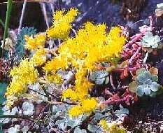
an occasional cactus. The Gorge is also home to over 800 species
of Wildflowers, almost
half of which are unique to its various micro-climates
The west end of the Gorge is very wet,
with rainfall approaching 100 inches annually; this moisture supports
a dense forest cover consisting of lichen- and moss-covered fir,
maple, and alder, with a thick understory of ferns. Around a bend
of the canyon just before Hood River (almost due north of Mt.
Hood) there is a dramatic change - rainfall drops to 30 inches
and the forest becomes pine and live oak, with occasional stands
of poison oak acting as understory. By the town of The Dalles,
another 25 miles to the east, rainfall drops again - to less than
14 inches, and vegetation consists of juniper, sagebrush, and
an occasional cactus. The Gorge is also home to over 800 species
of Wildflowers, almost
half of which are unique to its various micro-climates
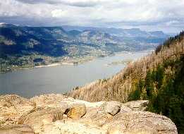
 Angel's Rest is a 1600-ft high rock
bluff (left) that projects out from the cliffs in the western
Gorge; the view upriver from its top (right) - note the brown
skeletons of trees on the slope to the right, the result of a
fire that swept over Angel's and up the ridge behind it in October
of 1996
Angel's Rest is a 1600-ft high rock
bluff (left) that projects out from the cliffs in the western
Gorge; the view upriver from its top (right) - note the brown
skeletons of trees on the slope to the right, the result of a
fire that swept over Angel's and up the ridge behind it in October
of 1996
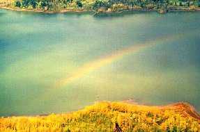
 It's not hard to imagine how Angel's
got its name when looking down at a rainbow from a perch on its
edge
It's not hard to imagine how Angel's
got its name when looking down at a rainbow from a perch on its
edge
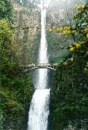
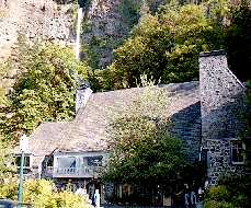
 Multnomah Falls (left), only 30 miles
east of downtown Portland on I-84, is one of the most visited
tourist sites in Oregon; the 542-ft main falls, fourth highest
in the US [framed by the Benson Bridge (1914)], and the 69-ft
lower falls plunge over cliffs that show six distinct layers of
basalt from the various lava flows that have occured in the area
over the last 25 million years. The Multnomah Falls Lodge (right),
designed by Portland architect A.E. Doyle, was built in 1925 to
capitalize on the tourist trade through the Gorge
Multnomah Falls (left), only 30 miles
east of downtown Portland on I-84, is one of the most visited
tourist sites in Oregon; the 542-ft main falls, fourth highest
in the US [framed by the Benson Bridge (1914)], and the 69-ft
lower falls plunge over cliffs that show six distinct layers of
basalt from the various lava flows that have occured in the area
over the last 25 million years. The Multnomah Falls Lodge (right),
designed by Portland architect A.E. Doyle, was built in 1925 to
capitalize on the tourist trade through the Gorge
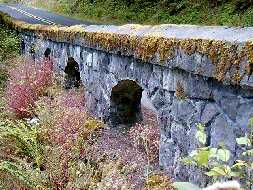
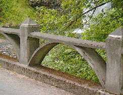
 Among the many distinctive architectural
features of the HCRH are its stonework railings (left) and its
bridges, represented here by the parabolic arches supporting the
100-ft concrete span of the Young Creek (Shepperd's Dell) Bridge
(1914; right), designed by Lancaster and K.R. Billner
Among the many distinctive architectural
features of the HCRH are its stonework railings (left) and its
bridges, represented here by the parabolic arches supporting the
100-ft concrete span of the Young Creek (Shepperd's Dell) Bridge
(1914; right), designed by Lancaster and K.R. Billner
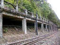
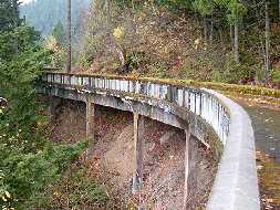
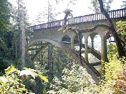 Many HCRC bridges, designed to carry
the road in the narrow space between railroad tracks and an adjacent
steep hillside, are really side-hill viaducts - the downhill side
is supported by columns while the uphill side rests on the slope;
a good example is the viaduct west of Multnomah Falls (left),
which is 400 ft long. The original HCRC bridge railings (right)
consist of horizontal concrete rails with triangular cross-sections,
supported by semi-elliptical arches and by concrete posts with
tapered tops
Many HCRC bridges, designed to carry
the road in the narrow space between railroad tracks and an adjacent
steep hillside, are really side-hill viaducts - the downhill side
is supported by columns while the uphill side rests on the slope;
a good example is the viaduct west of Multnomah Falls (left),
which is 400 ft long. The original HCRC bridge railings (right)
consist of horizontal concrete rails with triangular cross-sections,
supported by semi-elliptical arches and by concrete posts with
tapered tops
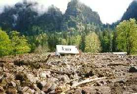
 The still visible second story of the
Royse house (1915), near Dodson in mid-Gorge, is now a magnet
for tourist buses; the rest of the house was buried under 15 feet
of muddy debris by a landslide on the night of February 6, 1996,
the result of torrential rains in the northwest corner of the
state
The still visible second story of the
Royse house (1915), near Dodson in mid-Gorge, is now a magnet
for tourist buses; the rest of the house was buried under 15 feet
of muddy debris by a landslide on the night of February 6, 1996,
the result of torrential rains in the northwest corner of the
state
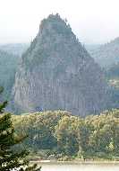
 Beacon Rock
State Park is on the Washington shore about 35 miles east of Portland
and 7 miles west of Cascade Locks; Yeon Park, across the river,
provides a good vantage point for viewing the "rock,"
a 6 million year old, 848-ft high plug of basalt (left) that once
occupied the neck of a small volcano, its outer walls now eroded
by the Columbia; Lewis and Clark, who camped at the rock's base
on October 31, 1805, first called it Beacon Rock, a name made
official in 1961 (it had been called Castle Rock in the interim).
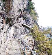
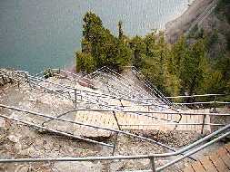
Henry J. Biddle purchased Beacon Rock in 1915 and dynamited a
trail to its summit; completed in 1918, the 0.9 mile trail contains
47 switchbacks (center, right); his heirs turned the rock over
to the state in 1935, providing the first of 19 parcels that make
up the present Beacon Rock State Park
Beacon Rock
State Park is on the Washington shore about 35 miles east of Portland
and 7 miles west of Cascade Locks; Yeon Park, across the river,
provides a good vantage point for viewing the "rock,"
a 6 million year old, 848-ft high plug of basalt (left) that once
occupied the neck of a small volcano, its outer walls now eroded
by the Columbia; Lewis and Clark, who camped at the rock's base
on October 31, 1805, first called it Beacon Rock, a name made
official in 1961 (it had been called Castle Rock in the interim).
Henry J. Biddle purchased Beacon Rock in 1915 and dynamited a
trail to its summit; completed in 1918, the 0.9 mile trail contains
47 switchbacks (center, right); his heirs turned the rock over
to the state in 1935, providing the first of 19 parcels that make
up the present Beacon Rock State Park
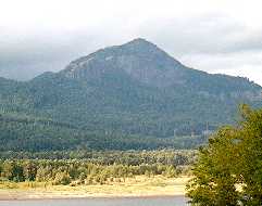
 Just to the east of BR is Hamilton
Mountain (2,438 ft; left), also in the park - the very popular
3.2 mile trail to its top begins just behind BR; the basalt cliffs
that top Hamilton (right), from a viewpoint on the trail as it
climbs past Little Hamilton
Just to the east of BR is Hamilton
Mountain (2,438 ft; left), also in the park - the very popular
3.2 mile trail to its top begins just behind BR; the basalt cliffs
that top Hamilton (right), from a viewpoint on the trail as it
climbs past Little Hamilton
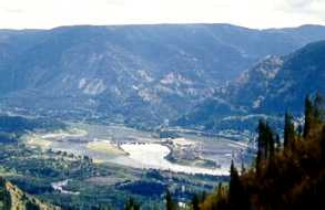
 Looking downriver from the steep switchbacks
of the upper Hamilton trail (left), with the peaks of Little Hamilton
and Beacon Rock in the foreground. View of the Bonneville Dam
complex (right) from the top of Hamilton - a wide streak of white
foam marks the Dam's spillway, located between Cascade and Bradford
Islands, with powerhouses on either side; the entrance to Eagle
Creek Canyon is just behind, framed by Ruckel Ridge on the east
and Wauna Point on the west. The Dam, first of four on the lower
Columbia, was dedicated by FDR on September 28, 1937
Looking downriver from the steep switchbacks
of the upper Hamilton trail (left), with the peaks of Little Hamilton
and Beacon Rock in the foreground. View of the Bonneville Dam
complex (right) from the top of Hamilton - a wide streak of white
foam marks the Dam's spillway, located between Cascade and Bradford
Islands, with powerhouses on either side; the entrance to Eagle
Creek Canyon is just behind, framed by Ruckel Ridge on the east
and Wauna Point on the west. The Dam, first of four on the lower
Columbia, was dedicated by FDR on September 28, 1937
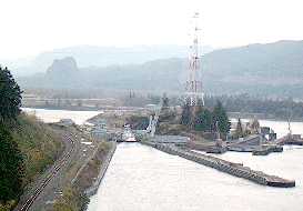
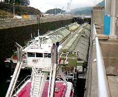
 The original navigation lock at Bonneville
Dam was the smallest of the 8 locks on the Columbia-Snake Inland
Waterway, which runs 465 miles from the Pacific to Lewiston, Idaho;
a trip thru the lock for a five-barge tow, common these days,
took nearly 8 hours because the tow had to be disassembled before
it could pass thru. A new lock (left) was recently completed at
Bonneville - although only 10 ft wider and 175 ft longer than
the original, the same tow can now pass thru intact, and passage
takes less than an hour, almost tripling the annual capacity of
the waterway; note the new 830-ft upstream guidewall to improve
safety of the approach to the lock's channel. The 110-ft long,
3000 hp Challenger tug, owned by Tidewater Barge Lines, and its
4 huge barges almost completely fill the new lock (right); Tidewater's
tugs and barges (some of which are over 270 ft long and can carry
over 1800 tons of grain) move about 80% of the river cargo above
Portland - which includes over 200 million bushels of wheat and
barley transported downriver each year from the Northwest's Inland
Empire
The original navigation lock at Bonneville
Dam was the smallest of the 8 locks on the Columbia-Snake Inland
Waterway, which runs 465 miles from the Pacific to Lewiston, Idaho;
a trip thru the lock for a five-barge tow, common these days,
took nearly 8 hours because the tow had to be disassembled before
it could pass thru. A new lock (left) was recently completed at
Bonneville - although only 10 ft wider and 175 ft longer than
the original, the same tow can now pass thru intact, and passage
takes less than an hour, almost tripling the annual capacity of
the waterway; note the new 830-ft upstream guidewall to improve
safety of the approach to the lock's channel. The 110-ft long,
3000 hp Challenger tug, owned by Tidewater Barge Lines, and its
4 huge barges almost completely fill the new lock (right); Tidewater's
tugs and barges (some of which are over 270 ft long and can carry
over 1800 tons of grain) move about 80% of the river cargo above
Portland - which includes over 200 million bushels of wheat and
barley transported downriver each year from the Northwest's Inland
Empire
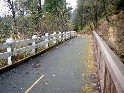
 Sparked by public outcry over the destruction
of the HCRH's Hood River Bridge, the Oregon Legislature in 1987
decreed that the unused sections of the HCRH should be restored
and connected to form a continuous pathway for bicyclists and
pedestrians, designated as the HCRH State Trail. The first completed
section (1997) covers the 1.4 miles from Eagle Creek to Tanner
Creek, coincidently the first segment of the HCRH to be abandoned
- a byproduct of Bonneville Dam construction that forced realignment
of about 4 miles of highway through Toothrock Tunnel (1936-7;
now used by the eastbound lanes of I-84); here the (glowing) tunnel
exit is shown below the new bridge (left) constructed for the
trail. Asphalt "shoulders" were removed from this section
of trail (right) during restoration to illustrate the original
16-18 ft width of the old highway, here bounded by two types of
restored railings; the original HCRH two-rail wooden guardrail
design on the left became a Federal highway standard in 1920 -
a steel-backed reproduction is used extensively on the HCRH
Sparked by public outcry over the destruction
of the HCRH's Hood River Bridge, the Oregon Legislature in 1987
decreed that the unused sections of the HCRH should be restored
and connected to form a continuous pathway for bicyclists and
pedestrians, designated as the HCRH State Trail. The first completed
section (1997) covers the 1.4 miles from Eagle Creek to Tanner
Creek, coincidently the first segment of the HCRH to be abandoned
- a byproduct of Bonneville Dam construction that forced realignment
of about 4 miles of highway through Toothrock Tunnel (1936-7;
now used by the eastbound lanes of I-84); here the (glowing) tunnel
exit is shown below the new bridge (left) constructed for the
trail. Asphalt "shoulders" were removed from this section
of trail (right) during restoration to illustrate the original
16-18 ft width of the old highway, here bounded by two types of
restored railings; the original HCRH two-rail wooden guardrail
design on the left became a Federal highway standard in 1920 -
a steel-backed reproduction is used extensively on the HCRH
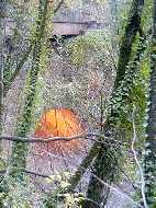
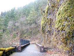
 A highlight of the EC-TC section [which
also provides access to the Portage Road, trans-Gorge (#400),
and Wauna Point trails on the cliffs above] is the 224-ft long,
multi-curved, HCRH side-hill viaduct (left) built around the basalt
mass of Toothrock bluff; the new bridge (shown above) replaces
a segment of viaduct that had been destroyed during construction
of the Toothrock Tunnel exit - it starts at the end of the viaduct
curve and runs past the face of the bluff (right)
A highlight of the EC-TC section [which
also provides access to the Portage Road, trans-Gorge (#400),
and Wauna Point trails on the cliffs above] is the 224-ft long,
multi-curved, HCRH side-hill viaduct (left) built around the basalt
mass of Toothrock bluff; the new bridge (shown above) replaces
a segment of viaduct that had been destroyed during construction
of the Toothrock Tunnel exit - it starts at the end of the viaduct
curve and runs past the face of the bluff (right)
 Go to Gorge-2 | Columbia
River Gorge | Return
to Home Page
Go to Gorge-2 | Columbia
River Gorge | Return
to Home Page