OLYMPIC PENINSULA
(Last updated 1/18/01)
Washington State's Olympic Peninsula
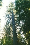
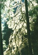
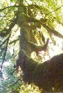
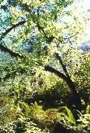
contains four distinct types of forests. Giant Sitka spruce (left)
and western red cedar are dominant in the temperate rain forest
along the Pacific coast, where cool Alaskan ocean currents, prevailing
westerly winds, and moderate year-round temperatures produce abundant
winter rain and summer fog - from 140 to over 160 inches of precipitation
a year; sunlight filtered through the mosses and drooping boughs
(center) suffuses the forest with a greenish glow. Further inland
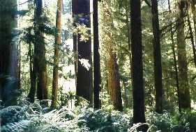
and at slightly higher elevations, the spruce disappears and Douglas
fir, western hemlock, bigleaf and vine maple, black cottonwood,
and an occasional grand fir dominate the drier lowland forest
(right). At still higher elevations, the western red cedar finally
disappears, marking the start of the montane forest zone.
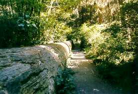
 The Olympic National Park contains
about 750 National Champions, the largest living specimen trees
of their species. The tallest Douglas fir, located along the South
Fork Hoh River Trail, is 298 ft high - elsewhere a huge fir log
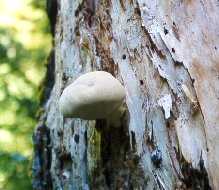
(left) defines the direction of almost 250 feet of trail. A wood
fungus (right) speeds the decay of a snag - more than 5,000 species
of mushrooms have been found in the forests of the peninsula
The Olympic National Park contains
about 750 National Champions, the largest living specimen trees
of their species. The tallest Douglas fir, located along the South
Fork Hoh River Trail, is 298 ft high - elsewhere a huge fir log
(left) defines the direction of almost 250 feet of trail. A wood
fungus (right) speeds the decay of a snag - more than 5,000 species
of mushrooms have been found in the forests of the peninsula
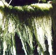
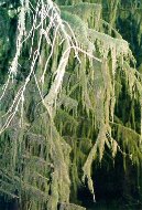
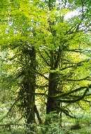
 Mosses, primarily common cat-tail and
coiled-leaf, and lichens, including common witch's hair and Methuselah's
beard, appear to hang from every branch in the heart of the rain
forest; the Hall of Mosses Nature Trail near the Hoh Visitors
Center is lined with almost unrecognizable moss-draped maples
(right)
Mosses, primarily common cat-tail and
coiled-leaf, and lichens, including common witch's hair and Methuselah's
beard, appear to hang from every branch in the heart of the rain
forest; the Hall of Mosses Nature Trail near the Hoh Visitors
Center is lined with almost unrecognizable moss-draped maples
(right)
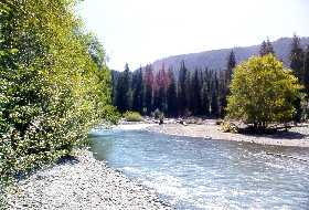
 The brighter sunlight along the river
produces a "forest" of maples, cottonwoods, and alders
along the banks of the Hoh River (left and center), and also along
the Skokomish River (right), located in the southeast corner of
the Park
The brighter sunlight along the river
produces a "forest" of maples, cottonwoods, and alders
along the banks of the Hoh River (left and center), and also along
the Skokomish River (right), located in the southeast corner of
the Park
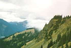
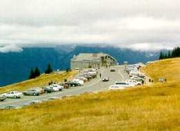
 A 17-mile long road climbs south into
the interior of the peninsula from Port Angeles; at higher elevations
the subalpine forest zone, marked by mountain hemlock, subalpine
fir, and Alaska cedar takes over (left). The road eventually leads
to the Hurricane Ridge Visitor Center, at 5242 ft (right)
A 17-mile long road climbs south into
the interior of the peninsula from Port Angeles; at higher elevations
the subalpine forest zone, marked by mountain hemlock, subalpine
fir, and Alaska cedar takes over (left). The road eventually leads
to the Hurricane Ridge Visitor Center, at 5242 ft (right)
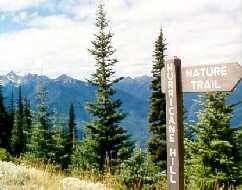
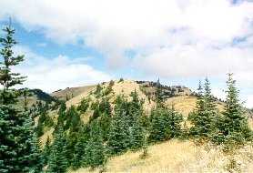
 A steep trail with spectacular views
that begins just beyond the Visitor's Center (left) leads to the
summit of Hurricane Hill (right), at 5757 ft barely above timberline
A steep trail with spectacular views
that begins just beyond the Visitor's Center (left) leads to the
summit of Hurricane Hill (right), at 5757 ft barely above timberline
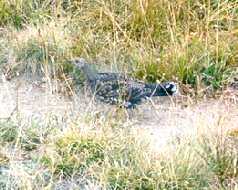
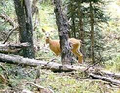
 Wildlife abounds in the area - a male
blue grouse (left) scampers along a well-worn path through the
tall grass; a mule deer (right) peers between the stunted trees
Wildlife abounds in the area - a male
blue grouse (left) scampers along a well-worn path through the
tall grass; a mule deer (right) peers between the stunted trees
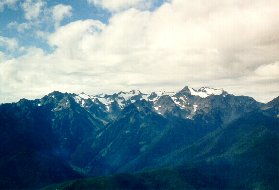
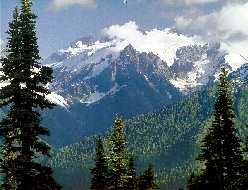
 The Olympic Mountains form the north/south
backbone of the peninsula. Originally a series of volcanic seamounts
on the bottom of the ocean, as the Juan de Fuca plate approached
the rim of North America 35 million years ago, the seamounts were
jammed against the continental plate, fracturing, folding, and
stacking together to create the forerunner of today's Olympics.
Water and glaciers have since carved the basalt crags that remain.
Though not very high, the mountains are seldom climbed because
of their glaciation and inaccessibility; they are crowned by over
260 glaciers, and the highest of Mount Olympus' four peaks, West
- at 7965 ft, can only be reached by a 26 mile trek up the Hoh
River trail.
The Olympic Mountains form the north/south
backbone of the peninsula. Originally a series of volcanic seamounts
on the bottom of the ocean, as the Juan de Fuca plate approached
the rim of North America 35 million years ago, the seamounts were
jammed against the continental plate, fracturing, folding, and
stacking together to create the forerunner of today's Olympics.
Water and glaciers have since carved the basalt crags that remain.
Though not very high, the mountains are seldom climbed because
of their glaciation and inaccessibility; they are crowned by over
260 glaciers, and the highest of Mount Olympus' four peaks, West
- at 7965 ft, can only be reached by a 26 mile trek up the Hoh
River trail.
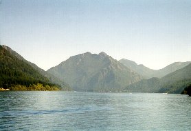
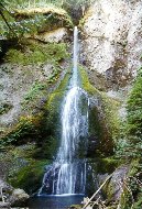
 Glacier-carved Lake Crescent (left),
on the northern edge of the Olympic range, is a 10-mile long,
620 ft deep freshwater lake - 2650 ft Mount Storm King defines
its east end; the 90 ft plunge and horsetail of Marymere Falls
(right), just to the southeast of Storm King
Glacier-carved Lake Crescent (left),
on the northern edge of the Olympic range, is a 10-mile long,
620 ft deep freshwater lake - 2650 ft Mount Storm King defines
its east end; the 90 ft plunge and horsetail of Marymere Falls
(right), just to the southeast of Storm King
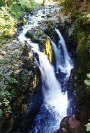
 The Sol Duc ("magic waters")
River has carved its valley a few miles west of Lake Crescent;
a short hike from the trailhead just past the Hot Springs Resort
leads to the 60 ft triple plunge of Sol Duc Falls
The Sol Duc ("magic waters")
River has carved its valley a few miles west of Lake Crescent;
a short hike from the trailhead just past the Hot Springs Resort
leads to the 60 ft triple plunge of Sol Duc Falls
 One of the most surprising and spectacular
features of the Park is its 60 miles of Pacific Ocean seacoast.
President Roosevelt managed to get the interior of the peninsula
designated as a National Park in 1938 - the bill passed by a single
vote in the Senate, but the coast was excluded despite the President's
wishes. Roosevelt then condemned or designated various coastal
segments as public works projects and placed them in the custody
of the Park Service, where they remained until 1953, when President
Truman added them to the Park by presidential proclamation. A
challenge to the proclamation mounted by the combined forces of
the Chamber of Commerce and the Park's superindendant on behalf
of logging interests followed, and was defeated only after Supreme
Court Justice William O. Douglas led a coalition of environmental
groups to defeat it in the media. The latest challenge has come
at the behest of oil companies who want to drill for oil offshore,
an effort supported by both the Reagan and Bush administrations,
and an issue still unresolved even though Congress made the offshore
area a Marine Sanctuary in 1988.
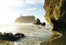
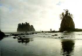
Second Beach is bounded by Quateata
and an offshore island wildlife refuge on the north (left); the
85-ft high Quillayute Needle and surrounding seastacks are the
Beach's centerpiece (right)
One of the most surprising and spectacular
features of the Park is its 60 miles of Pacific Ocean seacoast.
President Roosevelt managed to get the interior of the peninsula
designated as a National Park in 1938 - the bill passed by a single
vote in the Senate, but the coast was excluded despite the President's
wishes. Roosevelt then condemned or designated various coastal
segments as public works projects and placed them in the custody
of the Park Service, where they remained until 1953, when President
Truman added them to the Park by presidential proclamation. A
challenge to the proclamation mounted by the combined forces of
the Chamber of Commerce and the Park's superindendant on behalf
of logging interests followed, and was defeated only after Supreme
Court Justice William O. Douglas led a coalition of environmental
groups to defeat it in the media. The latest challenge has come
at the behest of oil companies who want to drill for oil offshore,
an effort supported by both the Reagan and Bush administrations,
and an issue still unresolved even though Congress made the offshore
area a Marine Sanctuary in 1988.
Second Beach is bounded by Quateata
and an offshore island wildlife refuge on the north (left); the
85-ft high Quillayute Needle and surrounding seastacks are the
Beach's centerpiece (right)
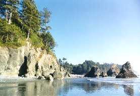
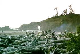
 Weathered driftwood logs mark the high
tide line (left); Teahwhit Head (right) defines the south boundary
of the Beach
Weathered driftwood logs mark the high
tide line (left); Teahwhit Head (right) defines the south boundary
of the Beach
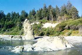
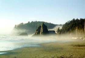
 Tree-covered seastacks (left) and Hole-in-the-Wall
(right) mark the northern boundary of Rialto Beach
Tree-covered seastacks (left) and Hole-in-the-Wall
(right) mark the northern boundary of Rialto Beach
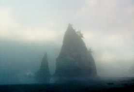
 Towards sunset, the fog rolls in with
the tide and Rialto turns ghostly
Towards sunset, the fog rolls in with
the tide and Rialto turns ghostly
 Outside the Park, most of the peninsula's
land is owned by logging companies and heavily clear-cut, even
on the many Indian reservations - almost the entire northern coast
is privately held, with little or no public access
Outside the Park, most of the peninsula's
land is owned by logging companies and heavily clear-cut, even
on the many Indian reservations - almost the entire northern coast
is privately held, with little or no public access
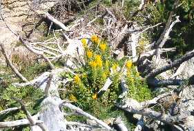
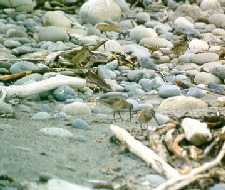
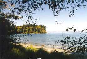 Long-billed dowitchers forage along
the 6-mile long Dungeness Spit, now a National Wildlife refuge,
near Sequim ("skwim") on the northeast coast - in the
rain shadow of the Olympics, the area gets less than 17"
of rain per year, compared to over 200" on Mt. Olympus 30
miles west. The New Dungeness Lighthouse (right), whose lamp was
first lit in December, 1857, now sits 1/2 instead of its original
1/6 of a mile from the tip of the Spit, thanks to the shifting
sands that maintain the Spit's existence
Long-billed dowitchers forage along
the 6-mile long Dungeness Spit, now a National Wildlife refuge,
near Sequim ("skwim") on the northeast coast - in the
rain shadow of the Olympics, the area gets less than 17"
of rain per year, compared to over 200" on Mt. Olympus 30
miles west. The New Dungeness Lighthouse (right), whose lamp was
first lit in December, 1857, now sits 1/2 instead of its original
1/6 of a mile from the tip of the Spit, thanks to the shifting
sands that maintain the Spit's existence
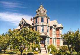
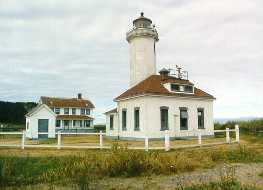
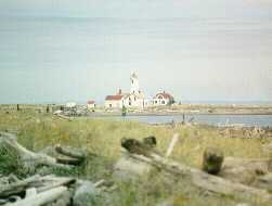 Named by Captain George Vancouver (for
the Marquis of Townshend) in 1792, the official dedication of
Port Townsend in the northeast corner of the Peninsula took place
on April 24, 1851; the city contains many Victorian buildings,
including the Starrett Mansion (left), built by George in 1889
as a wedding present for his wife Ann. The Point Wilson Lighthouse
(right) is located in Fort Worden State Park at the northeasterly
tip of the Peninsula
Named by Captain George Vancouver (for
the Marquis of Townshend) in 1792, the official dedication of
Port Townsend in the northeast corner of the Peninsula took place
on April 24, 1851; the city contains many Victorian buildings,
including the Starrett Mansion (left), built by George in 1889
as a wedding present for his wife Ann. The Point Wilson Lighthouse
(right) is located in Fort Worden State Park at the northeasterly
tip of the Peninsula
 Return to
Home Page
Return to
Home Page