WATERFALLS-1
(Last updated 7/8/03)
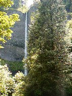
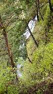
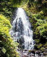
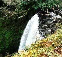
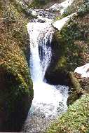
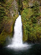
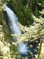
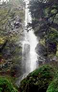
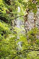
In the Columbia River Gorge: the first easily visited waterfall lies about 3 miles
east of the Gorge's western end in Guy W. Talbot State Park, on
land donated to the state in 1929 - the 249-ft plunge of Latourell
Falls (left), on the creek of the same name; about a mile's hike
up the creek, the 100-ft double-tiered Upper Latourell Falls (right)
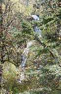
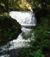
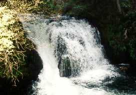
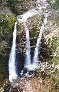
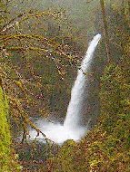
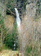
 A few miles further east, the lower
tiers of the 100-ft falls at Shepperd's Dell (left); another mile
east, the 160-ft double-tiered Bridal Veil Falls (left center),
one of the few falls below the HCRH; about 1.5 miles east of Bridal
Veil, the lower (right center) and upper (right) cascades of 175-ft
Coopey Falls - viewed from about 0.6 mile up the Angel's Rest
trail
A few miles further east, the lower
tiers of the 100-ft falls at Shepperd's Dell (left); another mile
east, the 160-ft double-tiered Bridal Veil Falls (left center),
one of the few falls below the HCRH; about 1.5 miles east of Bridal
Veil, the lower (right center) and upper (right) cascades of 175-ft
Coopey Falls - viewed from about 0.6 mile up the Angel's Rest
trail
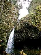
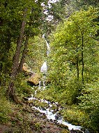
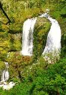
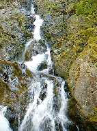
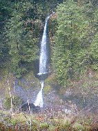
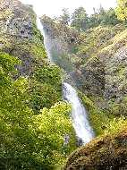
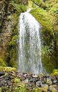
 Further east again, the 242-ft high
tiered descent of Wahkeena ("most beautiful") Falls
(left); viewed from ca 1/4 mile up the Wahkeena trail, a close-up
of the double-tiered upper section of Wahkeena (left center);
Wahkeena Creek plunges down the steep Gorge hillside in a seemingly
endless series of cascades along the trail (right center); the
30-ft fan of Fairy Falls (right) flows into Wahkeena Creek a little
over a mile from, and about 800 ft above, the trailhead
Further east again, the 242-ft high
tiered descent of Wahkeena ("most beautiful") Falls
(left); viewed from ca 1/4 mile up the Wahkeena trail, a close-up
of the double-tiered upper section of Wahkeena (left center);
Wahkeena Creek plunges down the steep Gorge hillside in a seemingly
endless series of cascades along the trail (right center); the
30-ft fan of Fairy Falls (right) flows into Wahkeena Creek a little
over a mile from, and about 800 ft above, the trailhead

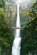
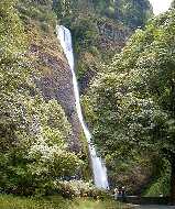
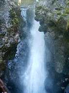
 Multnomah Falls (left), the fourth
highest in the US, is the most visited attraction in the Gorge
and, for that matter, in Oregon - the upper falls, framed in the
Benson Bridge, plunges 542 ft, while the lower falls adds another
69 ft. There are four more falls that can be seen along Multnomah
Creek if one ascends a few miles up the Larch Mountain trail,
which starts to the left of Multnomah Lodge; first encountered
is the series of three small block falls called Dutchman (center),
which drops a total of 60 ft; further up the trail one encounters
the 75 ft lower plunge of Double Falls (right)
Multnomah Falls (left), the fourth
highest in the US, is the most visited attraction in the Gorge
and, for that matter, in Oregon - the upper falls, framed in the
Benson Bridge, plunges 542 ft, while the lower falls adds another
69 ft. There are four more falls that can be seen along Multnomah
Creek if one ascends a few miles up the Larch Mountain trail,
which starts to the left of Multnomah Lodge; first encountered
is the series of three small block falls called Dutchman (center),
which drops a total of 60 ft; further up the trail one encounters
the 75 ft lower plunge of Double Falls (right)
 Just beyond, Upper Double (left) plunges
another 125 ft; the small 20-ft cascade of Upper Multnomah Falls
(right) caps the series on the main creek itself, but a number
of unnamed side creeks plunge into it from the cliffs of the canyon
further up the trail
Just beyond, Upper Double (left) plunges
another 125 ft; the small 20-ft cascade of Upper Multnomah Falls
(right) caps the series on the main creek itself, but a number
of unnamed side creeks plunge into it from the cliffs of the canyon
further up the trail
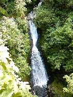
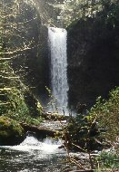
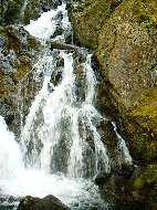
 Further east in the Gorge, the classic
shape of 176-ft Horsetail Falls (left); after ascending about
0.4 miles up the Horsetail Creek trail, approaching the 100-ft
plunge of Ponytail Falls (left center) - the trail actually passes
behind this falls; about a mile up the trail, the horsetail of
75-ft middle Oneonta Falls (right center), viewed from the bridge
over Oneonta Gorge; another 3/4 mile up the trail, which now parallels
Oneonta Creek, the 135-ft plunge of Triple Falls (really a triplet;
right)
Further east in the Gorge, the classic
shape of 176-ft Horsetail Falls (left); after ascending about
0.4 miles up the Horsetail Creek trail, approaching the 100-ft
plunge of Ponytail Falls (left center) - the trail actually passes
behind this falls; about a mile up the trail, the horsetail of
75-ft middle Oneonta Falls (right center), viewed from the bridge
over Oneonta Gorge; another 3/4 mile up the trail, which now parallels
Oneonta Creek, the 135-ft plunge of Triple Falls (really a triplet;
right)
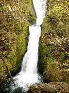
 A few miles past Dodson at mid-Gorge,
in John B. Yeon State Park, the 125-ft twin plunge of Upper McCord
Creek Falls (left), viewed from the upper Elowah trail; further
east, about 1/4 mile up Tanner Creek, a no-name falls on a side
creek drops 50 ft down a basalt cliff into the creek - the trail
passes the face of this falls on a bridge; another 3/4 of a mile
up the creek, the trail ends with a view of the 90-ft double-tiered
Wahclella Falls (right)
A few miles past Dodson at mid-Gorge,
in John B. Yeon State Park, the 125-ft twin plunge of Upper McCord
Creek Falls (left), viewed from the upper Elowah trail; further
east, about 1/4 mile up Tanner Creek, a no-name falls on a side
creek drops 50 ft down a basalt cliff into the creek - the trail
passes the face of this falls on a bridge; another 3/4 of a mile
up the creek, the trail ends with a view of the 90-ft double-tiered
Wahclella Falls (right)
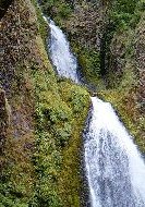
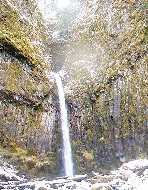
 Across the river on the Washington
side of the Gorge in Beacon Rock State Park, about 1 1/4 miles
up the Mt. Hamilton trail, a view of the multi-tiered 150-ft Rodney
Falls (left), the upper falls on Hardy Creek; a close-up of the
topmost segment from Pool of the Winds (center left), and of the
lower segment from the trail bridge (center right); the 120-ft
horsetail drop of Hardy Falls just downstream (right)
Across the river on the Washington
side of the Gorge in Beacon Rock State Park, about 1 1/4 miles
up the Mt. Hamilton trail, a view of the multi-tiered 150-ft Rodney
Falls (left), the upper falls on Hardy Creek; a close-up of the
topmost segment from Pool of the Winds (center left), and of the
lower segment from the trail bridge (center right); the 120-ft
horsetail drop of Hardy Falls just downstream (right)
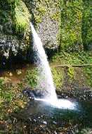
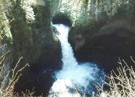
 On the Oregon side again, in Eagle
Creek Canyon, the 150-ft plunge of Metlako Falls (left) about
1 1/2 miles up the trail; the 30-ft plunge of Punchbowl Falls
(center) - one of the most photographed in the Gorge area, appears
a bit past the 2 mile mark; and the 80-ft horsetail of Loowit
Falls (right) can be seen on the opposite wall of the canyon at
about 3 1/4 miles
On the Oregon side again, in Eagle
Creek Canyon, the 150-ft plunge of Metlako Falls (left) about
1 1/2 miles up the trail; the 30-ft plunge of Punchbowl Falls
(center) - one of the most photographed in the Gorge area, appears
a bit past the 2 mile mark; and the 80-ft horsetail of Loowit
Falls (right) can be seen on the opposite wall of the canyon at
about 3 1/4 miles
 About 2 miles south of Cascade Locks
on the Pacific Crest Trail, an intersecting dirt road leads up
the creek to the 70-ft plunge of Dry Creek Falls (left), the water
source for the city; about two miles further south on the PCT,
the center 40-ft section of a segmented falls is visible above
Teapot Springs (left center); the 186-ft horsetail of Starvation
Creek Falls can be seen at a State Park (and rest stop) off I-84
a few miles past Cascade Locks in the eastern Gorge (right center,
right)
About 2 miles south of Cascade Locks
on the Pacific Crest Trail, an intersecting dirt road leads up
the creek to the 70-ft plunge of Dry Creek Falls (left), the water
source for the city; about two miles further south on the PCT,
the center 40-ft section of a segmented falls is visible above
Teapot Springs (left center); the 186-ft horsetail of Starvation
Creek Falls can be seen at a State Park (and rest stop) off I-84
a few miles past Cascade Locks in the eastern Gorge (right center,
right)
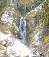
 A few hundred yards west of the Starvation
Creek rest stop near the start of the Mt. Defiance trail, the
lower portion of the 200-ft horsetail of Cabin Creek Falls (left)
is barely visible through the trees; a few hundred yards further
west, the 100-ft plunge of Hole-in-the-Wall Falls (center) - this
falls is man-made, the result of diverting Warren Creek thru a
tunnel blasted into a nearby basalt cliff during construction
of the Columbia Gorge Scenic Highway; a few hundred yards further
west, the trail crosses the lower segment of 250-ft Lancaster
Falls (right) on Wonder Creek
A few hundred yards west of the Starvation
Creek rest stop near the start of the Mt. Defiance trail, the
lower portion of the 200-ft horsetail of Cabin Creek Falls (left)
is barely visible through the trees; a few hundred yards further
west, the 100-ft plunge of Hole-in-the-Wall Falls (center) - this
falls is man-made, the result of diverting Warren Creek thru a
tunnel blasted into a nearby basalt cliff during construction
of the Columbia Gorge Scenic Highway; a few hundred yards further
west, the trail crosses the lower segment of 250-ft Lancaster
Falls (right) on Wonder Creek
 Go to Waterfalls-2 | Return to Home Page