OREGON COAST-2
(Last updated 2/8/08)
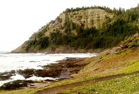
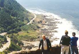
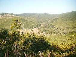
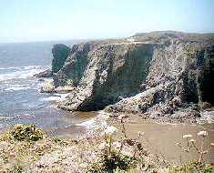
On the central coast, about 3 miles
south of Yachats, the 700-foot cliff of Cape Perpetua (left),
formed by an undersea shield volcano over 40 million years ago;
view from the top of the Cape (right), looking south towards the
Visitor's Center and to the tidal pools beyond.
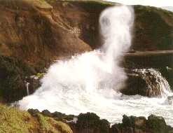
 Just past the pools, the Spouting Horn
sprays at high tide from an undersea cavern on the south side
of Captain Cook's Chasm.
Just past the pools, the Spouting Horn
sprays at high tide from an undersea cavern on the south side
of Captain Cook's Chasm.
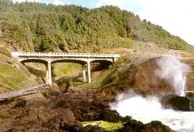
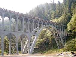
 About 11 miles further south at Devil's
Elbow State Park, the 619-ft long Cape Creek Bridge (1932; one
of Conde B. McCullough's designs), which abuts the Cape Creek
Tunnel, spans the creek with a 220-ft open spandrel decked arch.
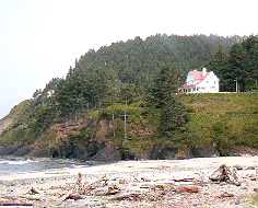
At the north end of the Park, a bluff in front of 1000-ft high
Heceta Head (right), named after the Portugese captain who first
saw it in 1775, holds the Queen-Anne duplex (1893) that once housed
the assistant lightkeepers' families; now owned by the Forest
Service, it's used as a B&B.
About 11 miles further south at Devil's
Elbow State Park, the 619-ft long Cape Creek Bridge (1932; one
of Conde B. McCullough's designs), which abuts the Cape Creek
Tunnel, spans the creek with a 220-ft open spandrel decked arch.
At the north end of the Park, a bluff in front of 1000-ft high
Heceta Head (right), named after the Portugese captain who first
saw it in 1775, holds the Queen-Anne duplex (1893) that once housed
the assistant lightkeepers' families; now owned by the Forest
Service, it's used as a B&B.
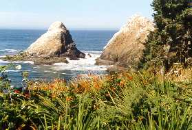
 The Devil's Elbow trail, which leads
to the house and light, provides a view of the Parrot Rocks bird
sanctuary, nesting area for thousands of Brandt's cormorants and
the tufted puffins for which the rocks were named (left). Heceta
Head lighthouse (right) sits 205 ft above the water - construction
of the still-operational (but now automated) light, the brightest
on the Coast, with its 640-prism first order Fresnell lens (that
can be seen from 21 miles at sea), was completed in 1894.
The Devil's Elbow trail, which leads
to the house and light, provides a view of the Parrot Rocks bird
sanctuary, nesting area for thousands of Brandt's cormorants and
the tufted puffins for which the rocks were named (left). Heceta
Head lighthouse (right) sits 205 ft above the water - construction
of the still-operational (but now automated) light, the brightest
on the Coast, with its 640-prism first order Fresnell lens (that
can be seen from 21 miles at sea), was completed in 1894.
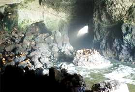
 Another mile south (about 11 north
of Florence), the inerior of the privately-owned Sea Lion Caves
(left), largest marine cavern (over 2 acres) in the US; the cave
is reached by an 11-story elevator from the cliff above. The cave
and the cliffs along the adjacent shore (right) house a breeding
population of Stellar sea lions, the only one in the lower 48
- Stellars are huge, with males weighing up to 1,500 lb compared
to about 600 for the more familiar male California sea lion.
Another mile south (about 11 north
of Florence), the inerior of the privately-owned Sea Lion Caves
(left), largest marine cavern (over 2 acres) in the US; the cave
is reached by an 11-story elevator from the cliff above. The cave
and the cliffs along the adjacent shore (right) house a breeding
population of Stellar sea lions, the only one in the lower 48
- Stellars are huge, with males weighing up to 1,500 lb compared
to about 600 for the more familiar male California sea lion.
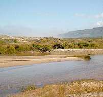
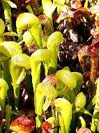
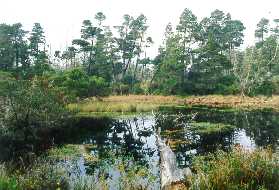
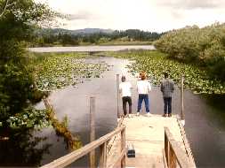
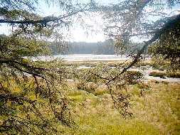
 About 6 miles further south, Holman
Vista on Sutton Creek (left) provides a good view of the start
of the dunes that abruptly replace the black lava rock of the
coast about a mile south of Cape Mountain; just across the highway
(about 5 miles north of Florence) at Darlingtonia Botanical Wayside,
a loop boardwalk trail over a bog provides access to broad swaths
of the insect-eating pitcher plant D. californica, or Cobra lily
(center). The Siuslaw River Bridge (1936; right) in Florence is
another one of the historical McCullough designs along the Coast
highway.
About 6 miles further south, Holman
Vista on Sutton Creek (left) provides a good view of the start
of the dunes that abruptly replace the black lava rock of the
coast about a mile south of Cape Mountain; just across the highway
(about 5 miles north of Florence) at Darlingtonia Botanical Wayside,
a loop boardwalk trail over a bog provides access to broad swaths
of the insect-eating pitcher plant D. californica, or Cobra lily
(center). The Siuslaw River Bridge (1936; right) in Florence is
another one of the historical McCullough designs along the Coast
highway.
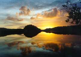
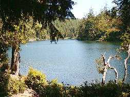
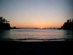
 About 3 miles south of Florence in
Jessie M. Honeyman State Park, a spectacular sunset reflected
in the calm waters of Cleawox Lake (left) - Cleawox is just one
in a series of freshwater lakes (starting with Sutton and Mercer)
that are separated from the ocean by dunes. A few miles further
south, a view from the Waxmyrtle Trail of a lagoon (right) formed
by a now isolated oxbow of the 3-mile long Siltcoos River
About 3 miles south of Florence in
Jessie M. Honeyman State Park, a spectacular sunset reflected
in the calm waters of Cleawox Lake (left) - Cleawox is just one
in a series of freshwater lakes (starting with Sutton and Mercer)
that are separated from the ocean by dunes. A few miles further
south, a view from the Waxmyrtle Trail of a lagoon (right) formed
by a now isolated oxbow of the 3-mile long Siltcoos River
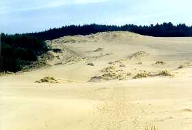
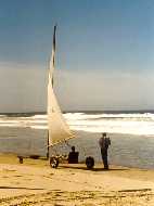
 The 36 mile stretch of nearly unbroken
beach that forms the Oregon Dunes National Recreation Area begins
about 9 miles south of Florence (13 north of Reedsport) - some
dunes are over 300 ft high; looking back to the Dunes Overlook
trailhead from the mile-long track through the sand to the beach
(left); a sand sailor cruises on the hard pack along the water's
edge (right)
The 36 mile stretch of nearly unbroken
beach that forms the Oregon Dunes National Recreation Area begins
about 9 miles south of Florence (13 north of Reedsport) - some
dunes are over 300 ft high; looking back to the Dunes Overlook
trailhead from the mile-long track through the sand to the beach
(left); a sand sailor cruises on the hard pack along the water's
edge (right)
 Fresh tracks mark the face of this
dune (left); about 8 miles north of Reedsport on the east side
of the highway, Tahkenitch ("many-armed") Lake, with
100 miles of shoreline, is a favorite with fishermen (right)
Fresh tracks mark the face of this
dune (left); about 8 miles north of Reedsport on the east side
of the highway, Tahkenitch ("many-armed") Lake, with
100 miles of shoreline, is a favorite with fishermen (right)
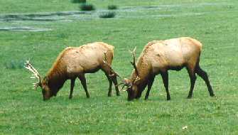
 Just 3 miles up the Umpqua River from
Reedsport, several bulls in the herd of over 100 Roosevelt elk
that can almost always be seen from the road that parallels the
Dean Creek Viewing Area
Just 3 miles up the Umpqua River from
Reedsport, several bulls in the herd of over 100 Roosevelt elk
that can almost always be seen from the road that parallels the
Dean Creek Viewing Area
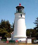
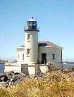
 Just south of Reedsport, on an inland
bluff south of the Umpqua River at the entrance to Winchester
Bay, the "new" Umpqua lighthouse (left; 1894) - the
first light, built (1857) closer to the ocean on the river's sandy
spit, disappeared without a trace in the flood of 1861; the 2-ton,
800-prism Fresnell lens that tops the 65-ft structure that replaced
it is still in operation. Lake Marie (right), a small inland jewel,
is located just behind the lighthouse in Umpqua State Park
Just south of Reedsport, on an inland
bluff south of the Umpqua River at the entrance to Winchester
Bay, the "new" Umpqua lighthouse (left; 1894) - the
first light, built (1857) closer to the ocean on the river's sandy
spit, disappeared without a trace in the flood of 1861; the 2-ton,
800-prism Fresnell lens that tops the 65-ft structure that replaced
it is still in operation. Lake Marie (right), a small inland jewel,
is located just behind the lighthouse in Umpqua State Park
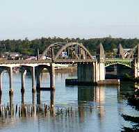
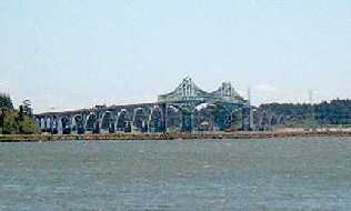
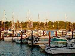
 The gracefully curved, mile-long McCullough
Bridge (1936; left), largest on the coast, spans the waters of
Coos Bay; the fishing village of Charleston (right) lies just
inside the jetties at the mouth of the Bay
The gracefully curved, mile-long McCullough
Bridge (1936; left), largest on the coast, spans the waters of
Coos Bay; the fishing village of Charleston (right) lies just
inside the jetties at the mouth of the Bay
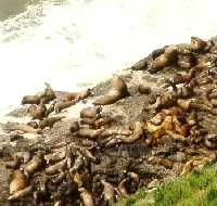
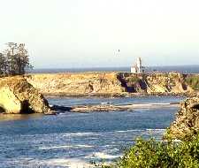
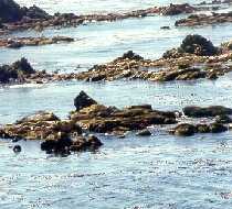
 View of the Cape Arago lighthouse (1934;
left), actually on an islet off Gregory Point about 3 miles north
of the Cape near the mouth of Coos Bay; Simpson Reef and the Shell
Islands (right), part of the Oregon Islands National Wildlife
Refuge, lie about 1/4 mile off Arago's North Cove - they're a
favorite year round haul-out spot for both California and Stellar
sea lions, as well as for harbor and northern elephant seals (the
latter weigh up to 2 1/2 tons)
View of the Cape Arago lighthouse (1934;
left), actually on an islet off Gregory Point about 3 miles north
of the Cape near the mouth of Coos Bay; Simpson Reef and the Shell
Islands (right), part of the Oregon Islands National Wildlife
Refuge, lie about 1/4 mile off Arago's North Cove - they're a
favorite year round haul-out spot for both California and Stellar
sea lions, as well as for harbor and northern elephant seals (the
latter weigh up to 2 1/2 tons)
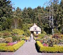
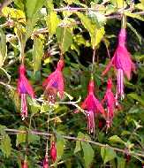
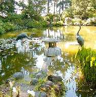
 The formal gardens and Garden House
at Shore Acres State Park (1942; left), former estate (1906) of
the North Bend timber and shipbuilding baron Louis B. Simpson,
at the north end of Cape Arago; fuchsias in the English garden
(center); lily pond in the Japanese garden (right)
The formal gardens and Garden House
at Shore Acres State Park (1942; left), former estate (1906) of
the North Bend timber and shipbuilding baron Louis B. Simpson,
at the north end of Cape Arago; fuchsias in the English garden
(center); lily pond in the Japanese garden (right)
 Sunset at the cliff-rimmed cove of
Sunset Bay State Park, just north of Shore Acres on Cape Arago
Sunset at the cliff-rimmed cove of
Sunset Bay State Park, just north of Shore Acres on Cape Arago
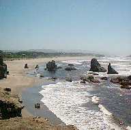
 The Seven Devils (left), a series of
steep ridges and canyons just south of Cape Arago; the tidelands
and marshes of 4,500 acre South Slough National Estuarine Research
Reserve (1974; right), the first of its kind in the country, on
an arm of Coos Bay south of Charleston
The Seven Devils (left), a series of
steep ridges and canyons just south of Cape Arago; the tidelands
and marshes of 4,500 acre South Slough National Estuarine Research
Reserve (1974; right), the first of its kind in the country, on
an arm of Coos Bay south of Charleston
 The 47-ft Coquille lighthouse (1896;
left) in Bullards Beach State Park sits on a low rock islet along
the north bank of the River - it was rammed by the bowsprit of
a ship in 1906. Just south of the town of Bandon, views of Elephant
Rock (center) from Coquille Point, and of sea stacks (right) from
the Face Rock Wayside just to the south - both are part of the
almost 1,500 rocks and islets of the Oregon Islands National Wildlife
Refuge (1970), which totals less than 800 acres but provides nesting
for more than 1 million sea birds
The 47-ft Coquille lighthouse (1896;
left) in Bullards Beach State Park sits on a low rock islet along
the north bank of the River - it was rammed by the bowsprit of
a ship in 1906. Just south of the town of Bandon, views of Elephant
Rock (center) from Coquille Point, and of sea stacks (right) from
the Face Rock Wayside just to the south - both are part of the
almost 1,500 rocks and islets of the Oregon Islands National Wildlife
Refuge (1970), which totals less than 800 acres but provides nesting
for more than 1 million sea birds
 Go to Coast-1 | Oregon
Coast Link | Return
to Home Page
Go to Coast-1 | Oregon
Coast Link | Return
to Home Page