GERMANY-1
(Last updated 5/21/03)
The "Free and Hanseatic
City" of Hamburg (Germany's second largest), located
68 miles inland from the North Sea on the Elbe, began in 811 as
a walled fortification built by Charlemagne at the mouth of the
river Alster. A cathedral soon followed, and in 834 the village
became the See of the archbishop Ansgar. Destroyed by the Vikings
in 845, and by the Obotriten in 938, 1066, and 1072, the town
nevertheless persevered - although the clergy withdrew to Bremen.
In the 12th c, the region came under the sovereignty of the Counts
of Schauenburg, who established a new city near the old archbishophric;
and on May 7th, 1189, Kaiser ("Emperor") Barbarossa
granted the city the privilege of duty free trade on the lower
Elbe - a "birthday" celebration is still held annually
in Hamburg's port on the date of his grant. During the 13th c,
crafts flourished, merchant guilds were established, and the city
grew in commercial importance. In 1241, to protect their overseas
trade, the Hansas (merchant associations) of Hamburg and nearby
Lübeck formed an alliance which, by the 1280s, had expanded
to include over 100 towns; the resulting Hanseatic League, which
was formally organized by its more than 200 members in 1358, prospered
over the next two centuries, becoming an independent political
power with its own army and navy. Hamburg, one of its most important
members, prospered as well, first incorporating surrounding villages,
eventually annexing areas as far away as the mouth of the Elbe.
The League declined during the 16th c, but Hamburg continued to
prosper, opening the first German stock exchange in 1558, restoring
city fortifications (1610-25) in time to successfully escape the
ravages of the Thirty Years War, gaining recognition as an imperial
"Free City" in 1768, joining the German Confederation
in 1815, and becoming one of the world's leading ports by 1840.
A 3-day fire destroyed nearly half its buildings in May of 1842,
but Hamburg quickly rebuilt, adding its first railway line later
that year, annexing significant new territories in 1867, and maintaining
its free harbor status as a concession for joining the German
Reich in 1888. By 1913 its population exceeded 1 million people
and it was the third largest port in the world.
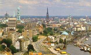
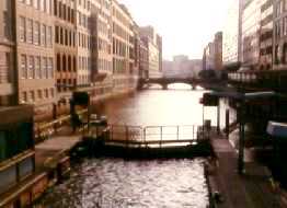
The Hamburg Hafen/port (left), with
60 dock basins and 42 miles of quays, is the second largest in
Europe (after Rotterdam); at upper left is the town's most popular
symbol, known locally as the "Michel," the 433-ft high
lantern turret tower (1786) of the baroque St. Michael's Church
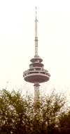
(1750-62, by Sonnin). "Tele-Michel," more formally the
Heinrich-Hertz-Turm (1965-8; right), is a new symbol of the city
- a 900-ft high television tower with a rotating restaurant and
observation deck at the 450-ft level
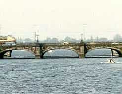
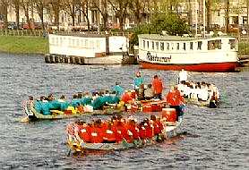
 Viewed from the southern shore, the
Lombardsbrücke/Bridge (1865-8; left) and the nearly parallel
Kennedybrücke (1953) behind it separate the small (45 acre),
almost square Binnen- (Inner) from the much larger (400 acre)
elongated Aussen- (Outer) Alster Lake, which dominate and shape
the character of inner city Hamburg. Crews practicing on the Binnenalster
for the boat races (right), one of the activities that marked
the 800th anniversary of Hamburg's port in 1989 - two Alster tour
boats are docked in the background
Viewed from the southern shore, the
Lombardsbrücke/Bridge (1865-8; left) and the nearly parallel
Kennedybrücke (1953) behind it separate the small (45 acre),
almost square Binnen- (Inner) from the much larger (400 acre)
elongated Aussen- (Outer) Alster Lake, which dominate and shape
the character of inner city Hamburg. Crews practicing on the Binnenalster
for the boat races (right), one of the activities that marked
the 800th anniversary of Hamburg's port in 1989 - two Alster tour
boats are docked in the background
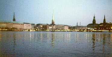
 Viewed at dusk from the eastern shore
of the Binnenalster, the historic spires of the old city's churches
and town hall dominate the skyline
Viewed at dusk from the eastern shore
of the Binnenalster, the historic spires of the old city's churches
and town hall dominate the skyline
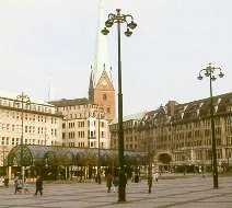
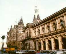
 After the fire of 1842, the Rathausmarkt/Town
Hall Square (left) was moved to a new location facing the Kleine
Alster, the small channel that drains the Binnenalster (its City
Lock also controls the level of the Alster lakes). The square's
buildings were somehow spared during the allied bombings of WWII
(which destroyed over 80% of the port and huge areas of the rest
of the city); however, they were severely damaged by flooding
from an unexpected storm tide in February, 1962, that killed 315
people in the city and displaced 200,000 more. Refurbished in
1982, the square is now used for outdoor concerts and festivals.
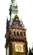
The massive 365 x 230 ft Rathaus/Town Hall (1886-97; center) had
to be built on (4,000) pilings because of the marshy character
of the ground along the old river bed - its two wings are home
to the two tiers of city and state government, the Bürgerschaft
and the Senate; the 367-ft high campanile (1897; right) of Town
Hall
After the fire of 1842, the Rathausmarkt/Town
Hall Square (left) was moved to a new location facing the Kleine
Alster, the small channel that drains the Binnenalster (its City
Lock also controls the level of the Alster lakes). The square's
buildings were somehow spared during the allied bombings of WWII
(which destroyed over 80% of the port and huge areas of the rest
of the city); however, they were severely damaged by flooding
from an unexpected storm tide in February, 1962, that killed 315
people in the city and displaced 200,000 more. Refurbished in
1982, the square is now used for outdoor concerts and festivals.
The massive 365 x 230 ft Rathaus/Town Hall (1886-97; center) had
to be built on (4,000) pilings because of the marshy character
of the ground along the old river bed - its two wings are home
to the two tiers of city and state government, the Bürgerschaft
and the Senate; the 367-ft high campanile (1897; right) of Town
Hall
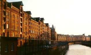
 In the short course of its 35 mile
trip to the Elbe, the Alster is joined by over 20 tributaries
and a maze of canals. Hamburg itself is interlaced with 40 miles
of waterways; those in the inner city and the harbor area are
called Fleets, e.g., the Alsterfleet (left), thru which the River
completes its trip to the Elbe from the Binnenalster, and the
winding, 17th c Nikolaifleet (right), lined with restored warehouses
and merchant's homes. Hamburg is also linked to Europe's inland
waterway system by shipping canals, both old and new: e.g., the
Stecknitz Canal (1390-8; in use until 1900, when it was replaced
by the Elbe-Trave Canal), key to the Hanseatic salt trade, connecting
Hamburg (to the west on the Elbe) and Lüneburg (to the south
on the Ilmenau) thru Lauenburg to Lübeck; the Lateral Canal,
connecting Hamburg (thru Dresden) to Prague; and the Havel, connecting
Hamburg (thru Berlin) to Poland
In the short course of its 35 mile
trip to the Elbe, the Alster is joined by over 20 tributaries
and a maze of canals. Hamburg itself is interlaced with 40 miles
of waterways; those in the inner city and the harbor area are
called Fleets, e.g., the Alsterfleet (left), thru which the River
completes its trip to the Elbe from the Binnenalster, and the
winding, 17th c Nikolaifleet (right), lined with restored warehouses
and merchant's homes. Hamburg is also linked to Europe's inland
waterway system by shipping canals, both old and new: e.g., the
Stecknitz Canal (1390-8; in use until 1900, when it was replaced
by the Elbe-Trave Canal), key to the Hanseatic salt trade, connecting
Hamburg (to the west on the Elbe) and Lüneburg (to the south
on the Ilmenau) thru Lauenburg to Lübeck; the Lateral Canal,
connecting Hamburg (thru Dresden) to Prague; and the Havel, connecting
Hamburg (thru Berlin) to Poland
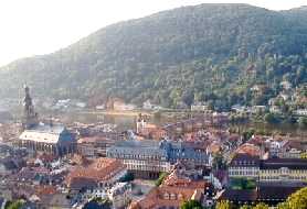
Heidelberg, a city of ca. 140,000 located at the mouth of
the Neckar Valley - framed by the Heiligenberg (Holy Mount) on
the north side of the river and the Königstuhl (King's Chair)
on the south - is known for its castle and its university. In
addition, the city has given its name to what, until very recently,
was the oldest hominid fossil found in Europe (in 1907), a 600,000+
year old jawbone from what turned out to be a new species, "Homo
heidelbergensis" (although the fossil was actually unearthed
in nearby Mauer); H.h. remains have since been found at several
other European sites (as well as in Asia and Africa), including
Boxgrove in the UK and Atapuerca in Spain - although the discoverers
of the latter assigned their fossils to yet another new species,
"H. antecessor," and some anthropologists still consider
the Mauer jaw to have come from an "unusual" H. erectus.
More recently the Heidelberg area has been occupied by the Celts
- in the 5th c BC; by the Romans - from 80-260 AD; by the St.
Michael Monastary - founded in 863 on the summit of the Heiligenberg;
and, finally, by a settlement that grew at the foot of a residence
built (1142) by the Bishop of Worms, first mentioned "officially"
as Heidelberg in a Schönau Monastery document in 1196.
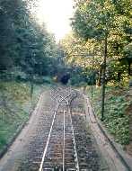
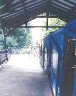
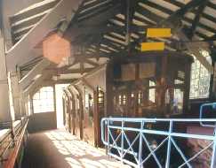
A funicular (left; the cable can be
seen slightly off center between the rails of the single track,
just below the double track passing section; originally water-ballasted,
now electric), operated by the Heidelberger Strassen- und Bergbahn
(HSB) AG, climbs to the top of the Königstuhl in two sections.
The lower section, from the Kornmarkt (one of the oldest squares
in the city) to the flat area at the top of the Molkenkur hill
(the "terrace"), opened in 1889, is 1,600 ft long, and
climbs 575 ft up a 39-43% incline in modern cars (center). The
upper section, from the Molkenkur terrace to the station at the
summit (1,860 ft), rises 856 ft on a 27-42% incline over a 3,350
ft long track, still using the original 1907 wooden cars (right)
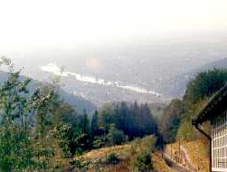
 The summit (site of the Landessternwarte/National
Observatory and the Max-Planck-Institute for Astronomy) provides
a spectacular view (in spite of the sun glare) of the Neckar River
as it enters the Rhine plain (left), and of the city against the
backdrop of the Heiligenberg (right)
The summit (site of the Landessternwarte/National
Observatory and the Max-Planck-Institute for Astronomy) provides
a spectacular view (in spite of the sun glare) of the Neckar River
as it enters the Rhine plain (left), and of the city against the
backdrop of the Heiligenberg (right)
 The earliest record of a Heidelberg
"fortress" (documenting its transfer to Duke Ludwig
I of Bavaria as part of the fiefdom of the Pfalz/Palatine), located
on the Molkenkur terrace, dates from 1225; this upper bastion
was destroyed by a gunpowder explosion (ignited by lightning)
in 1537 and never rebuilt. The presence of a "lower"
castle was first recorded in 1303; in 1400 its inner courtyard
was used as the site for a royal residence constructed by Prince
Elector Rupert III (who also founded the Ruprecht-Karls-Universitat,
Germany's oldest, in 1386); the evolution of castle to palace
continued over the next 220 years as residential buildings and
other features were added by a succession of Prince Electors,
especially Ludwig V (1508-44). The castle was started down the
path to its present state in 1622 when it was destroyed by Count
von Tilly, commander of the Bavarian army, who captured the city
during the Thirty Years War. Rebuilt by Elector Karl Ludwig (1649-80),
it was razed again in 1689 by the French, who captured the city
during the War of Palatine Succession, then returned in 1693 to
blow up its remaining fortifications and burn the town to the
ground. Elector Karl Theodor undertook restoration of the castle
once again in 1742, but work was discontinued in 1764 after lightning
sparked a fire that turned most of its buildings into empty shells.
As a result, Heidelberg Castle was never rebuilt, and lives on
instead as one of the most famous, and romantic, ruins in Europe...
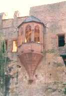
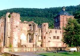
The upper floors of the Gothic style
Ruprecht Building (1400; left) underwent alterations under both
Ludwig V and Friedrich II (1544-56). L V also built the Gate Tower
(center; 1508), which rises 130 ft from within the moat - its
bottom room acted as the castle keep - and the Bridge House (1541;
right), which served as an outwork for the Gate House; a wooden
drawbridge originally connected them above the (now dry) moat
- the solid roadway was built in 1718
The earliest record of a Heidelberg
"fortress" (documenting its transfer to Duke Ludwig
I of Bavaria as part of the fiefdom of the Pfalz/Palatine), located
on the Molkenkur terrace, dates from 1225; this upper bastion
was destroyed by a gunpowder explosion (ignited by lightning)
in 1537 and never rebuilt. The presence of a "lower"
castle was first recorded in 1303; in 1400 its inner courtyard
was used as the site for a royal residence constructed by Prince
Elector Rupert III (who also founded the Ruprecht-Karls-Universitat,
Germany's oldest, in 1386); the evolution of castle to palace
continued over the next 220 years as residential buildings and
other features were added by a succession of Prince Electors,
especially Ludwig V (1508-44). The castle was started down the
path to its present state in 1622 when it was destroyed by Count
von Tilly, commander of the Bavarian army, who captured the city
during the Thirty Years War. Rebuilt by Elector Karl Ludwig (1649-80),
it was razed again in 1689 by the French, who captured the city
during the War of Palatine Succession, then returned in 1693 to
blow up its remaining fortifications and burn the town to the
ground. Elector Karl Theodor undertook restoration of the castle
once again in 1742, but work was discontinued in 1764 after lightning
sparked a fire that turned most of its buildings into empty shells.
As a result, Heidelberg Castle was never rebuilt, and lives on
instead as one of the most famous, and romantic, ruins in Europe...
The upper floors of the Gothic style
Ruprecht Building (1400; left) underwent alterations under both
Ludwig V and Friedrich II (1544-56). L V also built the Gate Tower
(center; 1508), which rises 130 ft from within the moat - its
bottom room acted as the castle keep - and the Bridge House (1541;
right), which served as an outwork for the Gate House; a wooden
drawbridge originally connected them above the (now dry) moat
- the solid roadway was built in 1718
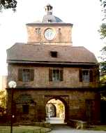
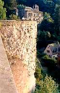
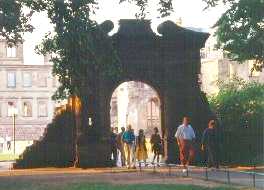
 The Burgweg (approach road from town)
passes through the Gate Hall, which lies beneath the Altan/platform
(both built by Friedrich IV, 1592-1610; left) - the foundation
of the Arsenal is visible on the right; view of the northern wall
of the castle (right) above the Gate Hall from the Great Terrace,
with the 2-story Arsenal (by L V) at lower left, the Bell Tower
and Friedrich Building above
The Burgweg (approach road from town)
passes through the Gate Hall, which lies beneath the Altan/platform
(both built by Friedrich IV, 1592-1610; left) - the foundation
of the Arsenal is visible on the right; view of the northern wall
of the castle (right) above the Gate Hall from the Great Terrace,
with the 2-story Arsenal (by L V) at lower left, the Bell Tower
and Friedrich Building above
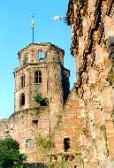
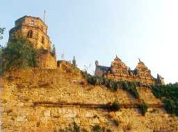 The octagonal Bell Tower (left) was
originally (13th c) a defensive structure, and only a single story
high - it was transformed into a seven story residence by five
subsequent stages of construction; a view of the north facade
of the Friedrich Building (1601-7, by F IV; center); a view of
the east wall of the Castle (right), with the Apothecary Tower
(lower tower 61 ft in diameter with 16 ft thick outer wall, 14th
c; three upper stories by F IV) at center, the Domestic and Ludwig
Buildings (both by L V) and the Sprung Tower (15th c) on the left,
the unadorned rear of the OttHeinrich Building, which now houses
the German Pharmaceutical Museum, and the Bell Tower on the right
The octagonal Bell Tower (left) was
originally (13th c) a defensive structure, and only a single story
high - it was transformed into a seven story residence by five
subsequent stages of construction; a view of the north facade
of the Friedrich Building (1601-7, by F IV; center); a view of
the east wall of the Castle (right), with the Apothecary Tower
(lower tower 61 ft in diameter with 16 ft thick outer wall, 14th
c; three upper stories by F IV) at center, the Domestic and Ludwig
Buildings (both by L V) and the Sprung Tower (15th c) on the left,
the unadorned rear of the OttHeinrich Building, which now houses
the German Pharmaceutical Museum, and the Bell Tower on the right
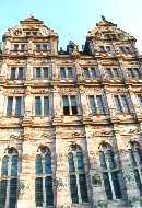
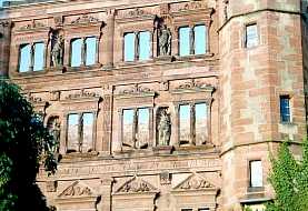
 Viewed from the Castle courtyard, the
top of the Bell Tower (left) is framed by the just visible Friedrich
Building and the Italianate Hall of Mirrors (1544-9; built by
Friedrich II) on the left, the OttHeinrich Building (built by
Otto Heinrich, 1557-66) on the right; a closer view of the ornate
courtyard facade of the Renaissance style OHB (center); the Rondel
(right) on the West Wall was once occupied by a gun battery
Viewed from the Castle courtyard, the
top of the Bell Tower (left) is framed by the just visible Friedrich
Building and the Italianate Hall of Mirrors (1544-9; built by
Friedrich II) on the left, the OttHeinrich Building (built by
Otto Heinrich, 1557-66) on the right; a closer view of the ornate
courtyard facade of the Renaissance style OHB (center); the Rondel
(right) on the West Wall was once occupied by a gun battery
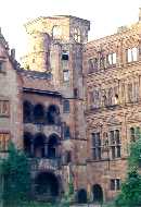
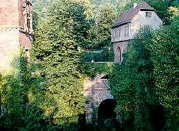
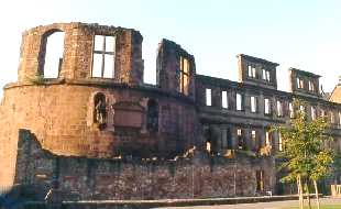
 Viewed from the Stückgarten/Gun
Park, the ruins of the Fat Tower (1533; by L V), originally 99
ft in diameter with circular walls 23 ft thick, and the English
Building (1610), built by Friedrich V (1610-32) for his wife Elizabeth,
daughter of James (Stuart) I of England (left); Friedrich also
built the Elizabeth Gate (1615; right), supposedly overnight,
as a surprise for his wife
Viewed from the Stückgarten/Gun
Park, the ruins of the Fat Tower (1533; by L V), originally 99
ft in diameter with circular walls 23 ft thick, and the English
Building (1610), built by Friedrich V (1610-32) for his wife Elizabeth,
daughter of James (Stuart) I of England (left); Friedrich also
built the Elizabeth Gate (1615; right), supposedly overnight,
as a surprise for his wife
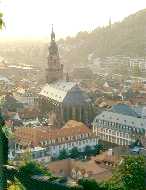
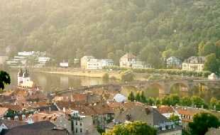
 The late Gothic style Heilig-Geist-Kirche
(Church of the Holy Ghost; left), built in 1398-41; the Rathaus
(1701-3), to its right, replaced the town hall burned by the French
in 1689; the Marktplatz occupies the square between them. On the
town side of the Neckar River, the white twin towers of the Medieval
bridge gate (originally part of the town wall) mark the entrance
to the stone-arched Alte Brücke (1786-88; Old Bridge), officially
the Karl-Theodor-Brücke (the towers were topped with Baroque
"helmets" when the bridge was built); this "permanent"
structure replaced at least four wooden predecessors dating back
to 1276
The late Gothic style Heilig-Geist-Kirche
(Church of the Holy Ghost; left), built in 1398-41; the Rathaus
(1701-3), to its right, replaced the town hall burned by the French
in 1689; the Marktplatz occupies the square between them. On the
town side of the Neckar River, the white twin towers of the Medieval
bridge gate (originally part of the town wall) mark the entrance
to the stone-arched Alte Brücke (1786-88; Old Bridge), officially
the Karl-Theodor-Brücke (the towers were topped with Baroque
"helmets" when the bridge was built); this "permanent"
structure replaced at least four wooden predecessors dating back
to 1276
Baden-Baden, a luxurious resort town of ca 50,000, is located
at the eastern edge of the Rhine Valley on the River Oos (as it
leaves the mountains of the Black Forest) about 60 mi south of
Frankfurt in southwestern Germany. The main part of town sits
on the side of the Florentine "Mountain" about 500 ft
above sea level, but the modern town also spreads over the surrounding
vineyard covered hillsides (called the "Rebland") and
contains peaks that reach to more than 3000 ft. The area has been
occupied by humans for at least 300,000 years, as evidenced by
a Neanderthal-like skull found (in 1933) near Steinheim, ca 35
mi to the east; stone age settlements in the Oos Valley date from
ca 10,000 BC, bronze age tombs from ca 1,000 BC.
B-B's "modern" history began
in ca 70 AD when a passing Roman legion discovered the area's
mineral hot springs. Twelve of them emerge from artesian wells
that originate from ca 5000 ft below the Florentine, providing
more than 150,000 gallons of mineral-rich (2500-3500 ppm) water
per day at temperatures varying from 115 to 153° F.
The Romans established an elaborate bath and settlement there,
which they named "Aquae Aureliae" after a visit by the
emperor Caracalla. [Caracalla, Roman emperor from 211-17 AD, was
originally named Lucius Septimius after his then senator father,
Septimius Severus, who was serving as provincial governor in central
Gaul when Lucius was born. Severus became emperor after the assasination
of the emperor Pertinax and a succession of civil wars against
a number of rivals; to legitimize his rule, Severus declared himself
to be the "son" of the former emperor (from 161-80)
Marcus Aurelius Antoninus, and also gave Lucius (then seven) the
former emperor's name; Caracalla was a nickname taken from the
Gallic tunic Lucius favored - it was actually derisive, never
used officially. Declared co-emperor in 209 along with his father
and younger brother Geta, Lucius had Geta murdered and his followers
massacred after their father's death in 211; after a 5-year reign
of terror, he was himself murdered by Marcus Macrinus, his Praetorian
prefect (who then succeeded him). Another bath, the Thermae of
Caracalla in Rome, staggering in both size (seating for 1500)
and opulence, also bears his name.] The Romans were finally forced
out of the region by the invading Alemanni in 282 AD, who in turn
were displaced by the Franks in the early 6th c.
The next event of note in the B-B region
appears to date from ca 1100, when Herrmann II, the first Margrave
of Baden, built the Hohenbaden Castle high on the cliffs of Battert
Crag above present day B-B.
Rediscovered by European nobility in
the 19th c, B-B is now one of the most elegant and sophisticated
playgrounds on the continent. Located in Spa Park, the Caracalla-Therme
(1985; left) and the Friedrichsbad (1869-77; built for the Grand
Duke, known as the "old bath"), B-B's modern spas, carry
on the Roman tradition. First mentioned in 1748, the tradition
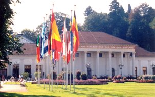
of (official) gambling in B-B is much more recent; B-B's elegant
and internationally famous casino, the Spielbank, considered one
of the most beautiful in the world, occupies several rooms in
the Kurhaus (1821-4, built by Friedrich Weinbrenner; right), also
located in Spa Park; containing a night club and restaurants as
well as concert halls and ballrooms, it is the focus of many of
the town's social activities, including several of international
repute, eg, the New Years Gala and the Grand Prix Ball, held in
conjunction with the Iffezheim international horse race
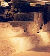
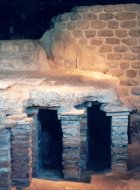
 Roman ruins (left, center) under the
Romerplatz and beneath the edge of the Friedrichsbad are well
preserved, and accessible to the public from beneath a nearby
garage. Entrance to the tunnel system that taps and distributes
water from the hot springs (right), on the SE hillside of the
Florentine Mountain below the New Castle
Roman ruins (left, center) under the
Romerplatz and beneath the edge of the Friedrichsbad are well
preserved, and accessible to the public from beneath a nearby
garage. Entrance to the tunnel system that taps and distributes
water from the hot springs (right), on the SE hillside of the
Florentine Mountain below the New Castle
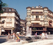
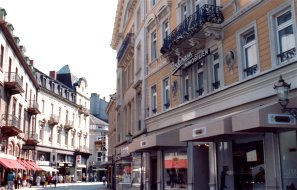
 Street scenes along Lichtentaler Allee,
B-B's main thoroughfare
Street scenes along Lichtentaler Allee,
B-B's main thoroughfare
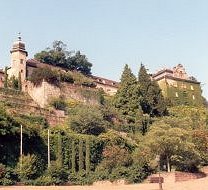
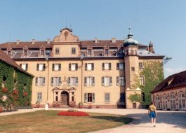
 The New Castle, built by the Margraves
of Baden on top of Florentine Mountain, replaced the original
(1384-99), destroyed by the French on August 24, 1689
The New Castle, built by the Margraves
of Baden on top of Florentine Mountain, replaced the original
(1384-99), destroyed by the French on August 24, 1689
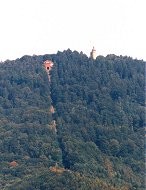
 From the balcony of the Orangerie at
the New Castle (the building to the far right in the picture on
the right, above), a view of the mountain railroad (1913) on the
steep face of the 2227-ft high Merkur Mountain opposite (left),
with an ascent gradient that reaches 54% and an observation tower
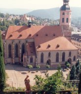
at its top. The 15th c Stiftskirche (left center); the Jesuit
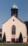
College (1632; right center); the plain facade of St Joseph's
Church (1961)
From the balcony of the Orangerie at
the New Castle (the building to the far right in the picture on
the right, above), a view of the mountain railroad (1913) on the
steep face of the 2227-ft high Merkur Mountain opposite (left),
with an ascent gradient that reaches 54% and an observation tower
at its top. The 15th c Stiftskirche (left center); the Jesuit
College (1632; right center); the plain facade of St Joseph's
Church (1961)
 Go to Germany-2 | Return
to Home Page
Go to Germany-2 | Return
to Home Page